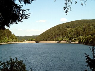
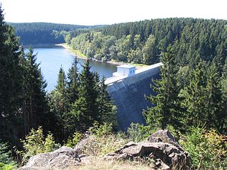
Söse Dam

Last updated
Söse Dam
Sosetalsperre.jpg
Relief Map of Germany.svg
Red pog.svg
Location of Söse Dam in Germany
Country Germany
Location Lower Saxony
Coordinates 51°44′21″N10°19′34″E / 51.73917°N 10.32611°E / 51.73917; 10.32611 Coordinates: 51°44′21″N10°19′34″E / 51.73917°N 10.32611°E / 51.73917; 10.32611
Construction began1928
(Harzwasserwerke)
Opening date1931
Dam and spillways
Type of dam Embankment dam
Height56 m (184 ft)
Length485 m (1,591 ft)
Width (crest)9 m (30 ft)
Dam volume1,900,000 m3 (67,000,000 cu ft)
Reservoir
Total capacity26,250,000 m3 (927,000,000 cu ft)
Catchment area 49 km2 (19 sq mi)
Surface area124 ha (0 sq mi)
Power Station
Installed capacity1.44 MW

The Söse Dam is a dam in the Lower Saxon part of the Harz mountains near Osterode in the German state of Lower Saxony.

Dam A barrier that stops or restricts the flow of surface or underground streams

A dam is a barrier that stops or restricts the flow of water or underground streams. Reservoirs created by dams not only suppress floods but also provide water for activities such as irrigation, human consumption, industrial use, aquaculture, and navigability. Hydropower is often used in conjunction with dams to generate electricity. A dam can also be used to collect water or for storage of water which can be evenly distributed between locations. Dams generally serve the primary purpose of retaining water, while other structures such as floodgates or levees are used to manage or prevent water flow into specific land regions. The earliest known dam is the Jawa Dam in Jordan, dating to 3,000 BC.

Osterode am Harz Place in Lower Saxony, Germany

Osterode am Harz often simply called Osterode, is a town in south-eastern Niedersachsen on the south-western edge of the Harz mountains. It was the seat of government of the district of Osterode. Osterode is located on the German Timber-Frame Road.

Lower Saxony State in Germany

Lower Saxony is a German state (Land) situated in northwestern Germany. It is the second-largest state by land area, with 47,624 km2 (18,388 sq mi), and fourth-largest in population among the 16 Länder federated as the Federal Republic of Germany. In rural areas, Northern Low Saxon and Saterland Frisian are still spoken, but the number of speakers is declining.

Contents

It was the first modern dam and reservoir complex (German: Talsperre) to be built in the Harz [1] and was constructed by the Harzwasserwerke between 1928 and 1931. It is used for flood prevention, electricity generation, supplying drinking water and for raising water levels during times of low water. The construction of the dam cost 14.7 million Reichsmarks at the time. The Harzwasserwerke still operate the dam today. In 1933 construction began on a long-distance water pipe from the Söse reservoir, whose northern branch goes as far as Bremen. Today it mainly supplies towns and communities in the Hildesheim and Hanover areas. Since 1980 the town of Göttingen has also been supplied with drinking water from the reservoir.

The Harzwasserwerke GmbH is a major German water company and dam operator based in Hildesheim, located within the German federal state of Lower Saxony.

Electricity generation process of generating electrical power

Electricity generation is the process of generating electric power from sources of primary energy. For electric utilities in the electric power industry, it is the first stage in the delivery of electricity to end users, the other stages being transmission, distribution, energy storage and recovery, using the pumped-storage method.

Drinking water water safe for consumption

Drinking water, also known as potable water, is water that is safe to drink or to use for food preparation. The amount of drinking water required varies. It depends on physical activity, age, health issues, and environmental conditions. Americans, on average, drink one litre of water a day and 95% drink less than three litres per day. For those who work in a hot climate, up to 16 litres a day may be required. Water is essential for life.

Main dam

The main barrier is an earth-fill dam with a central concrete core and clay sealing. The hydro-electric power station, which is used to supply electricity at peak loading periods, has a power of 1.44 MW and an annual energy output of 3.10 GWh. The spillway is located on the southern abutment of the dam with the hillside.

Spillway structure for controlled release of flows from a dam or levee

A spillway is a structure used to provide the controlled release of flows from a dam or levee into a downstream area, typically the riverbed of the dammed river itself. In the United Kingdom, they may be known as overflow channels. Spillways ensure that the water does not overflow and damage or destroy the dam.

Abutment

In engineering, abutment refers to the substructure at the ends of a bridge span or dam whereon the structure's superstructure rests or contacts. Single-span bridges have abutments at each end which provide vertical and lateral support for the bridge, as well as acting as retaining walls to resist lateral movement of the earthen fill of the bridge approach. Multi-span bridges require piers to support ends of spans unsupported by abutments. Dam abutments are generally either side of a valley or gorge but may be artificial in order to support arch dams such as Kurobe Dam in Japan.

Pre-dam

The Söse Reservoir has a pre-dam (Vorsperre) upstream, which is 200 m long and 20 m high and has a volume of 0.75 million m³. Its reservoir acts as a sediment trap to catch any particles in the river before they get to the main reservoir. In addition there is also a stilling basin (Ausgleichsbecken) below the primary dam, with a 10 m high dam wall, which controls any irregularity arising from the flow of water through the primary dam, power station and waterworks.

Leisure

Camping, fishing and walking are permitted. The path around the reservoir is 9 km long. There used to be a restaurant by the main dam, but it has since been demolished.

The pre-dam. SoeseVorsperre.jpg
The pre-dam.
Rotors of a Francis turbine from the Sose Dam power station Laufrad-Soesetalsperre.jpg
Rotors of a Francis turbine from the Söse Dam power station

See also

Notes

International Standard Book Number Unique numeric book identifier

The International Standard Book Number (ISBN) is a numeric commercial book identifier which is intended to be unique. Publishers purchase ISBNs from an affiliate of the International ISBN Agency.

Related Research Articles

Hydroelectricity electricity generated by hydropower

Hydroelectricity is electricity produced from hydropower. In 2015, hydropower generated 16.6% of the world's total electricity and 70% of all renewable electricity, and was expected to increase about 3.1% each year for the next 25 years.

Castaic Dam

Castaic Dam is an embankment dam in northern Los Angeles County, California, near the unincorporated area of Castaic. Although located on Castaic Creek, a major tributary of the Santa Clara River, Castaic Creek provides little of its water. The lake is the terminus of the West Branch of the California Aqueduct, part of the State Water Project. The dam was built by the California Department of Water Resources and construction was completed in 1973. The lake has a capacity of 325,000 acre feet (401,000,000 m3) and stores drinking water for the western portion of the Greater Los Angeles Area.

Tarbela Dam dam in Pakistan

Tarbela Dam is an earth-filled dam on the Indus River in Khyber Pakhtunkhwa, Pakistan. It is the largest earth-filled dam in the world, and also the largest dam by structural volume. Located in the Swabi and Haripur Districts of Khyber Pakhtunkhwa, the dam is about 30 km (20 mi) from the city of Swabi, 105 km (65 mi) northwest of Islamabad, and 125 km (80 mi) east of Peshawar.

Sorpe Dam reservoir near the town of Sundern in Germany

The Sorpe Dam is a dam on the Sorpe river, near the small town of Sundern in the district of Hochsauerland in North Rhine-Westphalia, Germany.

Ecker Dam architectural structure

The Ecker Dam is a gravity dam in the Harz mountain range near Bad Harzburg, Germany. Constructed between 1939 and 1943, it is today operated by the Harzwasserwerke company. The dam's reservoir impounds the waters of the Ecker river and mainly serves for drinking water supply.

Grane Dam reservoir in Germany

The Grane Dam is a dam above the village of Astfeld/Herzog-Juliushütte in the borough of Langelsheim in the Lower Saxon part of the Harz mountains.

Innerste Dam embankment dam

The Innerste Dam is a dam on the Innerste river, which lies near Langelsheim and Wolfshagen in the Harz mountains. It was built between 1963 and 1966 and belongs to the Harzwasserwerke. Its purposes are the supply of drinking water, flood protection, water flow regulation and hydroelectric power generation. The average annual discharge through the Innerste Dam is 60 million m³.

Sieber (Herzberg am Harz) village in the Harz Mountains, Germany

Sieber is a village in the borough of Herzberg am Harz in the district of Göttingen in South Lower Saxony (Germany).

Oderteich reservoir in Germany

The Oderteich is an historic reservoir about seven kilometres northeast of Sankt Andreasberg in the Upper Harz in central Germany. It was built by miners from St. Andreasberg in the years 1715 to 1722 and, today, is an important component of the water supply network known as the Upper Harz Water Regale. Moreover, for 170 years, from the time it was completed to the end of the 19th century, the Oderteich had the largest dam in Germany. The dam lies at a height of 725 m above NN by the B 242 federal highway, about a kilometre west of its intersection with the B 4.

Upper Harz Ponds

The Upper Harz Ponds are found mainly around the mining town of Clausthal-Zellerfeld and the nearby villages of Buntenbock and Hahnenklee in the Upper Harz mountains of central Germany. There are around 70 ponds in total, both large and small. They were built by the miners of the Upper Harz, mostly between the 16th and 18th centuries, and are important components of the cultural monument known as the Upper Harz Water Regale - a network of dams, ditches, ponds and tunnels that was built to supply much-needed water power for the mining industry in the Harz mountains. Today the Water Regale is being proposed as a UNESCO World Heritage Site. About half the dammed ponds are classified today as reservoirs, but they have now become characteristic features of the Upper Harz and are home to some extremely rare plant and animal species.

Dyke Ditch

The Dyke Ditch is the longest artificial ditch in the Upper Harz in central Germany. Its purpose was to collect surface runoff for the operation of the Upper Harz mining industry from precipitation-heavy regions a long way away. It was laid in 1732 and continually extended eastwards until 1827. Its original length was about 25 km; this was successively shortened by water tunnels between 1820 and 1861 to around 19 km. It is a central component of the Upper Harz Water Regale. Its takes its name from the Sperberhai Dyke which is, in fact, an embankment on top of which the Dyke Ditch runs in an aqueduct in order to cross a depression.

Oker Dam reservoir in Germany

The Oker Dam is a dam in the Harz mountains in Lower Saxony, Germany. It is fed by the River Oker.

Oder Dam dam in Germany

The Oder Dam is a dam in the Harz mountains of Germany. It lies above Bad Lauterberg in the district of Göttingen in Lower Saxony and impounds the river Oder. The dam went into service in 1934 after taking 3 years to build. The owner and operator of the Oder Dam is the Harzwasserwerke.

Zillierbach Dam reservoir in Germany

The Zillierbach Dam lies in the East Harz in the German state of Saxony-Anhalt near the town of Elbingerode (Harz) and impounds the Zillierbach stream. It supplies drinking water to several villages in the High Harz as well as the town of Wernigerode; it also provides flood protection.

Königshütte Dam architectural structure

The Königshütte Dam is a dam in the German state of Saxony-Anhalt in the Harz mountains. It impounds the River Bode and lies between Königshütte and Susenburg. It is a so-called storage reservoir (Überleitungssperre) forming part of the Rappbode Dam system.

Upper Harz Water Regale

The Upper Harz Water Regale is a system of dams, reservoirs, ditches and other structures, much of which was built from the 16th to 19th centuries to divert and store the water that drove the water wheels of the mines in the Upper Harz region of Germany. The term regale, here, refers to the granting of royal privileges or rights in this case to permit the use of water for mining operations in the Harz mountains of Germany.

Lower Harz Pond and Ditch System

Within the Lower Harz region are still many traces of the historical water management facilities used by the mining industry. In addition to water-carrying ditches and ponds, there are also long-abandoned ditches and dry pond beds. The Lower Harz Pond and Ditch System, which forms the major part of these old water management facilities, lies in the central Lower Harz, almost entirely within the borough of the present-day town of Harzgerode.

References