California is a U.S. state on the western coast of North America. Covering an area of 163,696 sq mi (423,970 km2), California is geographically diverse. The Sierra Nevada, the fertile farmlands of the Central Valley, and the arid Mojave Desert of the south are some of the major geographic features of this U.S. state. It is home to some of the world's most exceptional trees: the tallest, most massive, and oldest. It is also home to both the highest and lowest points in the 48 contiguous states. The state is generally divided into Northern and Southern California, although the boundary between the two is not well defined. San Francisco is decidedly a Northern California city and Los Angeles likewise a Southern California one, but areas in between do not often share their confidence in geographic identity. The US Geological Survey defines the geographic center of the state at a point near North Fork, California.

Mount Diablo is a mountain of the Diablo Range, in Contra Costa County of the eastern San Francisco Bay Area in Northern California. It is south of Clayton and northeast of Danville.

Sierra de San Pedro Mártir is a mountain range located within southern Ensenada Municipality and southern Baja California state, of northwestern Mexico.

The Santa Lucia Mountains or Santa Lucia Range is a rugged mountain range in coastal central California, running from Monterey County southeast for 105 miles (169 km) into central San Luis Obispo County. It includes Cone Peak, which at 5,158 feet (1,572 m) tall and three miles (5 km) from the coast, is the highest peak in proximity to the ocean in the lower 48 United States. The range forms the eastern boundary of the Big Sur region, and was a barrier to exploring the coast of California for early Spanish explorers.

Junipero Serra Peak is the highest mountain in the Santa Lucia Mountains of California. It is also the highest peak in Monterey County. It is named after Franciscan Friar Junípero Serra, founder of the California Missions.

Mount Hamilton is a mountain in California's Diablo Range, in Santa Clara County, California. Mount Hamilton, at 4,265 feet (1,300 m) is a mountain overlooking Santa Clara Valley and is the site of Lick Observatory, the World's first permanently occupied mountain-topobservatory. The asteroid 452 Hamiltonia, discovered in 1899, is named after the mountain. Golden eagle nesting sites are found on the slopes of Mount Hamilton. On clear days, Mount Tamalpais, the Santa Cruz Mountains, Monterey Bay, the Monterey Peninsula, and even Yosemite National Park are visible from the summit of the mountain.

The Gabilan Range or Gabilan Mountains are a mountain range in the Southern Inner California Coast Ranges System, located in Monterey County and San Benito County of central California. Pinnacles National Park is located in the southern section of the range.

Split Mountain is a fourteener in the Sierra Nevada of the U.S. state of California, near the southeast end of the Palisades group of peaks. It is the only fourteener in the watershed of the South Fork Kings River, and rises to 14,064 ft (4,287 m), making it the eighth-highest peak in the state.
Picacho del Diablo is the highest peak on the Baja California peninsula, measuring 3,096 metres (10,157 ft). It is alternately called Cerro de la Encantada, "Hill of the Enchanted", "Hill of the Bewitched". The peak is located in the Sierra de San Pedro Mártir, part of the Peninsular Ranges, in the Mexican state of Baja California.

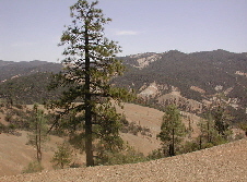
San Benito Mountain is the highest mountain in the Diablo Range of California. The highest point is at an elevation of 5,267 feet (1,605 m). The rock is composed of asbestos (chrysotile), an ultramafic rock. It weathers to produce serpentine soils with characteristically low levels of nutrients like nitrogen, phosphorus, potassium, and calcium, and high levels of magnesium and heavy metals including nickel and chromium. This means little vegetation grows in the area though there are some plants that only grow on such soils like the local endemic San Benito evening primrose. Some of the highest peaks are clad in a unique pine and incense cedar forest.
Hat Mountain is a mountain located in the Warner Mountains south of Eagle Peak in California. The peak, which rises to an elevation of 8,741 feet (2,664 m), is the highest point in Lassen County. Lost Lake is located to the northwest of the summit. Most of the precipitation that falls on Hat Mountain is snow due to the high elevation.
Laveaga Peak is a mountain located in the Diablo Range in California. Its summit rises to an elevation of 3,804 feet (1,159 m). The peak is on the boundary between Merced County and San Benito County and is the highest point in Merced County. The mountain is high enough to receive some snowfall during winter.
Mount Stakes is a mountain in the Diablo Range in California. The peak is located on the Santa Clara–Stanislaus county line; rises to an elevation of 3,810 feet (1,161 m) and is the highest point in Stanislaus County. It is 22 miles (35 km) west of Newman and 32 miles (51 km) southeast of Livermore. Some snow falls on the peak during the winter.
Hot Springs Mountain is a peak located in the Peninsular Ranges in California. The mountain rises to an elevation of 6,535 feet (1,992 m) and is the highest point in San Diego County. Some snow falls on the mountain peak during winter. It is located in a remote region of the county, 4 miles from the community of Warner Springs, 12 miles from Borrego Springs, and 50 miles from San Diego. The mountain and its immediate surroundings belong to the Los Coyotes Band of Cahuilla and Cupeno Indians. As of 2011, the mountain can be accessed via a gated dirt road, and prospective hikers are admitted to the reservation subject to a nominal entry fee.
Mount Boardman is located in the Diablo Range in California. The summit is near a point where Santa Clara, Alameda, Stanislaus, and San Joaquin counties meet. It was named for W. F. Boardman, the Alameda County surveyor between 1865 and 1869.
Discovery Peak is a peak in the Diablo Range of California and is the highest point in Alameda County. The officially unnamed peak is also known as Valpe Ridge–Rose Flat due to its location near Rose Flat. The area is high enough to receive occasional snowfall during the winter, which generally melts within a few days of falling. Although it is on private property, the Ohlone Wilderness Trail, in Sunol Regional Wilderness, comes to within about 1 mile (1.6 km) of the summit.

Glass Mountain, on the Inyo National Forest, is one of the tallest peaks in Mono County, California. The peak lies 20 miles (32 km) southeast of the shoreline of Mono Lake and is the highest point on the four mile long sinuous Glass Mountain Ridge.

The Sierra Pinta or Sierra Pintas are a narrow remote block faulted northwest-southeast trending mountain range, about 22 miles (35 km) long located in southwestern Arizona in the arid northwestern Sonoran Desert, just north of the Pinacate Reserve of northern Sonora, Mexico. The mountains derive their name from visitor descriptions of its multicolored hues when viewed at sunrise and sunset.
Zwang Peak is a mountain in the Diablo Range, 8 miles (13 km) southwest of Avenal, and about 12 miles (19 km) from Interstate 5 in Kings County, California. Its summit is at an elevation of 3,081 feet (939 m). The peak was named for cattle rancher Jake Zwang (1880–1968), who came to the area in 1906 to start a cattle ranch southwest of Avenal. Garza Creek has its source near this peak.