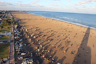
Marina Beach is a natural urban beach in Chennai, Tamil Nadu, India, along the Bay of Bengal. The beach runs from near Fort St. George in the north to Foreshore Estate in the south, a distance of 6.0 km (3.7 mi), making it the longest natural urban beach in the country. The Marina is primarily sandy, unlike the short, rocky formations that make up the Juhu Beach in Mumbai. The average width of the beach is 300 m (980 ft) and the width at the widest stretch is 437 m (1,434 ft). Bathing and swimming at the Marina Beach are legally prohibited because of the dangers, as the undercurrent is very turbulent. It is one of the most crowded beaches in the country and attracts about 30,000 visitors a day during weekdays and 50,000 visitors a day during the weekends and on holidays. During summer months, about 15,000 to 20,000 people visit the beach daily.

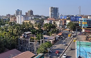
Mangalore, officially known as Mangaluru, is the chief port city of the Indian state of Karnataka. It is located between the Arabian Sea and the Western Ghats mountain range about 352 km (219 mi) west of Bangalore, the state capital. Mangalore is the state's only city to have all four modes of transport—air, road, rail and sea. The population of the urban agglomeration was 619,664 according to the 2011 national census of India.

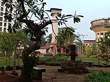
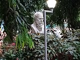
Kadri Park is a park located in Kadri Gudde. It is the largest park in Mangalore. This park contains a musical fountain and has hosted the Karavali Utsav. The park is famous for flower shows in Mangalore.

Deralakatte is a major educational, healthcare, commercial & residential locality in the south-eastern part of Mangalore city in Dakshina Kannada district of Karnataka state. It is 9 km (5.6 mi) away from the Karnataka-Kerala state border. It is popularly known as the University Town with more number of student population, universities & the stretch from Thokottu junction to Konaje is also known as the Medical corridor road due to the presence of many premium educational institutions & healthcare facilities where Deralakatte lies in between. It is close to Mangalore University, Konaje, Mudipu Infosys, Soorya Infratech Park, Thokottu & Ullal. Ullal beach, Someshwar Beach, Pilikula Nisargadhama are some of the nearest tourist destinations. This locality houses the NITTE University, Yenepoya University, Father Muller Charitable Institutions, Fathers Mullers Homeopathic Medical college hospital and Kanachur Groups of institutions and Hospital. It is a largest University locality in Mangalore after Manipal university in terms of students from all over the country and other parts of the world.

St. Aloysius Chapel, or the chapel of St. Aloysius College, is a Christian chapel in Mangalore in the state of Karnataka in southwest India. The Chapel is situated in the heart of the city on the Lighthouse Hill.

Kaup (Kapu), is a town in Udupi district of Karnataka, India. It lies on the way between Udupi and Mangalore beside National Highway 66. A road from Kaup goes to interior places like Manchakal and Shirva. It is 13 km south of Udupi and 40 km north of Mangalore. It is famous for its lighthouse and the three Mariamma temples and a fort built by Tippu Sultan. Kapu is declared as one of the Taluks in Udupi district by Govt of Karnataka. Kapu was renamed as Kaup by the British.
Thokkottu is a commercial Junction to the south of Mangalore city on National Highway 66 & also the gateway to Mangalore city from the South (Kerala). It is one of the major and busiest junctions of Mangalore city wherein one road goes towards east to Deralakatte and Konaje, educational hubs with several premium educational institutions and few IT companies, the other road towards west goes to Ullal. This junction connects Mangalore city, second major city of Karnataka with Talapady & Kerala. A flyover is constructed in the junction to reduce the congestion for the travellers travelling between Mangalore city & Kerala. The creation of educational institutions in Deralakatte & Konaje has led to the construction of many commercial complexes in the area.
Kankanadi or Kankanady is one of the major upscale commercial and residential localities of Mangalore city. It houses many highrise buildings and transforming into a highrise hub of Mangalore CBD region along with its major counterparts like Bejai, Kadri, Attavar & Falnir. It is one of the busiest localities of Mangalore.

Pilikula Nisargadhama is a multi-purpose tourist attraction, at Vamanjoor, eastern part of Mangalore city in Karnataka, managed by the District Administration of Dakshina Kannada. It is a major tourist attraction of Mangalore. It attracts large number of tourists due to the availability of multiple facilities.
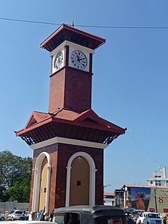
Hampankatta is the centre of Mangalore City, Karnataka. Hampankatta also called as Happananakatte/Hampankatte/Hampananakatte/Hampanakatte. Most of the public utilities are located here and the locality boasts the most buzzing commercial activity in the city.

Ullal Beach is situated on the southwestern seaboard of the Indian sub-continent, adjacent to Ullal town, 10 km south of the city of Mangalore, Karnataka, India. Attractions are its picturesque stretch of Coconut trees, fishermen's lane, the ruined fort of Abbakka Devi and 16th century Jain temples. A resort is also situated nearby.

Bejai is one of the major localities in Mangalore city, Karnataka, India. The series of Bharath malls, Bharath mall & Bharath mall 2, are located here. It is one of the upscale & the busiest residential cum commercial localities of Mangalore. Bejai - Kadri belt is also regarded as the Manhattan of Mangalore with many high-rise buildings. One notable project in Bejai is Palace Gardens which provides eco-friendly affordable luxury apartments.

Light House Hill is situated in Hampankatta, the heart of Mangalore City in the southern India. It was built by Hyder Ali and was used as watch tower for Sultanate of Mysore Navy.

Bondel is a residential locality in Mangalore city, Karnataka, India. It is one of the upscale residential localities of Mangalore. Bondel along with Maryhill houses many highrise buildings and also developing rapidly as a commercial center. It lies in Airport road, which originates in KPT Junction and extends till Mangalore International Airport. Kavoor, one of the major localities of Mangalore is located nearby. This locality is close to the airport too.
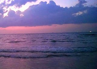
Panambur Beach is a beach in the city of Mangalore in the Indian state of Karnataka.

NITK Beach is situated in Surathkal, the northern part of Mangalore city, Karnataka. This beach is also known as Surathkal beach. It was later named after the nearby NITK .It is a private beach.

Karnad Sadashiva Rao Road or popularly known as K S Rao Road is one of the busiest in Mangalore, Karnataka, India. It runs from PVS Circle at one end to join Balmatta Road at the other. This road is named after the indian freedom fighter Karnad Sadashiva Rao.

The city of Mangalore is proclaimed as the gateway to Karnataka and lies nestled between the blue waters of the Arabian Sea and the green, towering hills of the Western Ghats. The 184 square km city is spread out over the backwaters of the two rivers, Netravati and Gurpura.

Balmatta is one of the major commercial localities of Mangalore CBD region in Karnataka state of India. Balmatta Pre-University college, situated in this locality was built in 1912. It is one of the busiest localities and surrounded by Hampankatta, Kankanadi and Kadri, which are major localities of Mangalore.