Tai Lam Country Park, established on 23 February 1979, is a country park located in Tai Lam, at the south of Yuen Long Town, Kam Tin and Shek Kong and east of Tuen Mun Town, in the western New Territories of Hong Kong. This country park has an area of 54 km².
The Shing Mun Country Park is a country park of Hong Kong, hugging the Shing Mun Reservoir.

Tai Wai is an area in the New Territories, Hong Kong, located between Sha Tin and the Lion Rock, within the Sha Tin District.

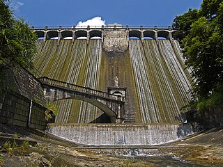
Plover Cove Reservoir, located within Plover Cove Country Park, in the northeastern New Territories, is the largest reservoir in Hong Kong in terms of area, and the second-largest in terms of volume. It is the world's first freshwater coastal lake constructed from an arm of the ocean. Its main dam, which disconnected Plover Cove from the sea, was one of the largest in the world at the time of its construction.

Shing Mun Reservoir is a reservoir in Hong Kong. It is located in Shing Mun, the area between Tsuen Wan and Sha Tin, in the New Territories. Administratively, it is located within the boundaries of Tsuen Wan District.

The MacLehose Trail is a 100-kilometre hiking trail that crosses much of the New Territories, Hong Kong, starting from Pak Tam Chung, Sai Kung District in the east to Tuen Mun Town, Tuen Mun District in the west. The path is marked by distance posts at 500-metre intervals. The trail is named after Murray MacLehose, Baron MacLehose of Beoch, the longest-serving governor of Hong Kong, who established the Country Parks and was himself an enthusiastic hiker. The trail passes through a variety of natural scenery including beaches and mountains.
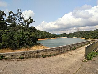
Kowloon Reservoir, part of the Kowloon Group of Reservoirs, is a reservoir in Sha Tin District, Hong Kong, located within the Kam Shan Country Park. The total water storage capacity is 353 million gallons and the total cost of construction was $619,000.

Lam Tei is an area in the Tuen Mun District of the New Territories, Hong Kong. The region lies at the north end of Tuen Mun city. It is highly rural, with Miu Fat Buddhist Monastery being a landmark of the region.

Shek Pik is an area located along the southwestern coast of Lantau Island, Hong Kong. When the Shek Pik Reservoir was built, villages at Shek Pik were demolished and the villagers were relocated to other parts of Lantau Island and to Tsuen Wan. Below the dam of the reservoir is Shek Pik Prison.
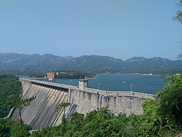
Shek Pik Reservoir is a reservoir in Shek Pik on Lantau Island in Hong Kong. Built between 1957 and 1963, it has a storage capacity of 24 million cubic metres and is the third largest reservoir in Hong Kong after High Island Reservoir and Plover Cove Reservoir.
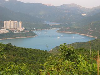
Tai Tam Harbour is a harbour in the innermost part of Tai Tam Bay in the southeastern part of Hong Kong Island, in the Southern District of Hong Kong. It is located at the estuary of Tai Tam Tuk.
The Aberdeen Reservoirs are a group of two reservoirs, consisting of the Upper Aberdeen Reservoir (香港仔上水塘) and the Lower Aberdeen Reservoir (香港仔下水塘), in Aberdeen, Hong Kong.
Cyclists in Hong Kong have the same rights and responsibilities as all other road users, except for prohibitions from expressways and some other designated locations, such as all tunnel areas, the Tsing Ma and Tsing Sha control areas, many elevated roads and many underpasses. At least one hand must be kept on the handlebars at all times. Cyclists must use a cycle track wherever one is present.

Sham Chung is a Hakka village and an area of Neolithic settlement in Hong Kong. It is located in the south of Tolo Channel, beside Three Fathoms Cove on the Sai Kung Peninsula. Administratively, it is part of Tai Po District.

Wu Kau Tang is an area in Northeast New Territories, Hong Kong. It is administratively part of North District and is enclosed by Plover Cove Country Park on all sides. It is the starting point of the Wu Kau Tang Country Trail and the Plover Cove Reservoir Country Trail.

Hung Shui Hang Reservoir is a reservoir located to the north of Kau Keng Shan, Tuen Mun, New Territories, Hong Kong. It is located at the northwestern edge of Tai Lam Country Park and less than one kilometre away from Lam Tei Reservoir. Like Lam Tei Reservoir, it is part of Tai Lam Chung Reservoir's further water supply plan and an irrigation reservoir. The reservoir is divided into two reservoirs. The water from the reservoir flows through Tan Kwai Tsuen and Chung Uk Tsuen and then through Hung Shui Kiu, passing through the west side of Tin Shui Wai and finally empties into the Deep Bay.