Kwai Tsing is one of the 18 districts of Hong Kong. It consists of two parts - Kwai Chung and Tsing Yi Island. Kwai Tsing is part of the New Territories. It had a population of 520,572 in 2016. The district has the third least educated residents and their income is below average.

The Tsuen Wan line is one of the ten lines of the metro network in Hong Kong's MTR. It is indicated in red on the MTR map.

Most of the walled villages of Hong Kong are located in the New Territories.
Castle Peak Road is the longest road in Hong Kong. Completed in 1920,it runs in the approximate shape of an arc of a semi-circle. It runs West from Tai Po Road in Sham Shui Po,New Kowloon,to Tuen Mun,then north to Yuen Long then east to Sheung Shui,in the very north of the New Territories. It is divided into 22 sections. It serves south,west and north New Territories,being one of the most distant roads in early Hong Kong.

Pat Heung is an area in the middle of New Territories,Hong Kong. Located at the east of Kam Tin and north of Shek Kong,it is the exit to Sheung Shui and Fanling. Administratively,it belongs to Yuen Long District.

Route 5 is a strategic route in Hong Kong from eastern to western Kowloon and New Kowloon,and ends in Tsuen Wan in the New Territories where it connects to Route 9. It is one of the most seriously congested routes in Kowloon,as it serves as an interchange to the Hung Hom Cross-Harbour Tunnel,especially during peak hours.

Lam Tei is an area in the Tuen Mun District of the New Territories,Hong Kong. The region lies at the north end of Tuen Mun city. It is highly rural,with Miu Fat Buddhist Monastery being a landmark of the region.
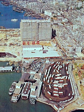
Jordan Road Ferry Pier or Ferry Point (1924–1998) is a demolished pier originally located at Jordan Road,Jordan,Hong Kong.

Tin Hau temples in Hong Kong are dedicated to Tin Hau (Mazu). Over 100 temples are dedicated to Tin Hau in Hong Kong. A list of these temples can be found below.

Mountain Shore is a full market value development in Tai Shui Hang,Ma On Shan,Sha Tin District,New Territories,Hong Kong. The estate is one of the Hong Kong Housing Society's Sandwich Class Housing Scheme projects converted into private developments.

The Hong Kong government started developing new towns in the 1950s to accommodate Hong Kong's booming population. During the first phase of development,the newly developed towns were called "satellite towns",a concept borrowed from the United Kingdom,of which Hong Kong was a colony. Kwun Tong,located in eastern Kowloon,and Tsuen Wan,located in the south-west of the New Territories,were designated as the first satellite towns,when the urban area in Hong Kong was still relatively small,restricted to the central and western parts of Kowloon Peninsula and the northern side of Hong Kong Island. Wah Fu Estate was also built in a remote corner on the southern side of Hong Kong Island,with similar concepts but at a smaller scale.

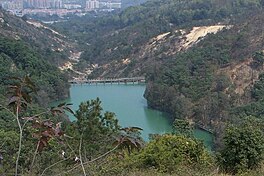
Lam Tei Reservoir is a funnel-shaped reservoir located at the back hill of Lingnan University in Fu Tei,Tuen Mun,Hong Kong with an area of 17,000 m2 and a water storage capacity of 116,000 m3. It is located at the western edge of Tai Lam Country Park and less than one kilometre away from Hung Shui Hang Reservoir. Like Hung Shui Hang Reservoir,it is part of Tai Lam Chung Reservoir's further water supply plan and an irrigation reservoir. The water from the reservoir eventually flows through the Tuen Mun River and empties into the Castle Peak Bay. The reservoir can be accessed by Stage 2 of the Tuen Mun Trail.