Tai Long Sai Wan

Last updated • 6 min readFrom Wikipedia, The Free Encyclopedia
Overlooking Sai Wan. Sai Wan.jpg
Overlooking Sai Wan.
Sai Wan. Tai Long Sai Wan.jpg
Sai Wan.
Houses in Sai Wan. House in Sai Wan.jpg
Houses in Sai Wan.
Star of the Sea Mass Centre and Hoi Sing School in Sai Wan. Hoi Sing School Campus, Sai Wan, Sai Kung part 1 in December 2023.jpg
Star of the Sea Mass Centre and Hoi Sing School in Sai Wan.
Restaurants in Sai Wan. Xi Wan Cun  - Sai Wan Village - 2015.01 - panoramio.jpg
Restaurants in Sai Wan.
Mural in Sai Wan. SaiWanArt1.jpg
Mural in Sai Wan.

Sai Wan (Chinese :西灣; lit.'West Bay') is a beach in Sai Kung Peninsula, Hong Kong. To distinguish it from other bays and beaches of the same name, it is commonly known as Tai Long Sai Wan, as it is one of the four main beaches of Tai Long Wan. It came first in the Hong Kong Best 10 Scenic Sites Election in 2006. [1]

Contents

The beaches in the Tai Long Sai Wan area are not suitable for swimming because of the presence of strong rip currents year-round, which means swimmers could be pulled into the open sea when caught in a rip current. [2] [3] [4] Many drowning fatalities have occurred because of the rip currents.

Administration

Sai Wan is a recognized village under the New Territories Small House Policy. [5]

History

The genealogy of the Li family of Tai Long Sai Wan mentions that their ancestors settled in Tai Long Wan and the surrounding areas during the period from 1465 to 1487. [6]

Sai Wan used to be a typhoon shelter for fishing boats but the High Island Reservoir project blocked the shortcut channel. [7]

Features

The Star of the Sea Mass Centre (海星彌撒中心) in Sai Wan is one of the historic churches of Sai Kung Peninsula. It was built in 1953, rebuilt in 1963, and restored in 2021. [8] The Hoi Sing School (海星學校) is adjacent to it.

Scenery

Sai Wan is situated in Sai Kung East Country Park at Stage 2 of the MacLehose Trail. It is next to Ham Tin Village, which has a restaurant that rents out camping equipment and surf boards apart from serving dishes. [9]

It is characterized by white sand and clear blue waters, which is attributable to its relative inaccessibility. [10] It is quiet and untainted, usually visited by junk-trippers and hikers only. [11]

It has been described as one of the best scenic spots in Sai Kung East or even Hong Kong. It came first in the Hong Kong Best 10 Scenic Sites Election in 2006. [1]

Accidents

Tai Long Wan translates to "Big Wave Bay" in Cantonese, which indicates its strong currents. It is also not a gazetted public beach, which means it has no lifeguard and is not managed by the Leisure and Cultural Services Department. There is also no shark nets. It is not recommended for swimming.

Hong Kong Underwater Archaeological Association vice chairman and diving instructor Johny Lee said it was a wide beach with a narrow opening to the open sea, causing strong currents especially during September. He remarked that it was good for diving as the water was clear and one could observe the marine life of the area. However, he also noted that the strong current made it dangerous and people should be very careful if they decide to swim there.

Fatalities

A number of drowning fatalities have happened in the bay. [12]

Development controversy

On 16 July 2010, it was reported that a large private development is under way in a site directly behind Sai Wan. It was revealed that businessman Simon Lo Lin-shing, chairman of Mongolia Energy Corporation and Vision Values Holdings, has acquired several plots of an abandoned village for a total of about HK$16 million to form the site that falls just outside the Hong Kong Country Parks & Special Areas and is not covered by any Outline Zoning Plans. [10]

The concerned strip of land, around 10,000 square metres in size, has been cleared of vegetation by diggers. [18] A warning sign is put up on the excavation site to warn against trespassing.

The nature of the private development is unclear. Villagers claimed that a private lodge will be built with artificial ponds, a tennis court and separate apartment. [18] Meanwhile, a spokeswoman for Vision Values Holdings said that there were no plans for any large-scale works, and that because the owner was very green himself, the land would be developed in a low-profile way. Lo also claimed he would be building an organic garden with pools for public use on the site. [19]

As of 23 July 2010, more than 68,000 people have joined the Facebook group that opposes the private development. [20] Green groups are planning a protest hike, tentatively set for 25 July 2010. A leading conservationist has said that the incident will give a bad impression to the UNESCO, which will be asked to grant World Heritage status to the Hong Kong National Geopark. [21]

Many were also infuriated with the government for not doing more to stop the destruction. After the reporting of the incident by the media on 16 July 2010, Secretary for the Environment Edward Yau Tang-wah was inquired about the incident on the next day but said he knew nothing about it. [22] Yau visited the site on 20 July 2010 and said the government had to strike a balance between respecting private land and protecting the environment. [23] Diggers have been mostly working on private land but a small section of the site is over government land. Yau warned the land owner that any redevelopment on agricultural land requires approval from the Lands Office, otherwise no construction work should proceed. The government has promised to meet with the landowner to work out a plan that will satisfy all parties concerned. [24]

Peter Li, campaign manager at the Conservancy Association, expressed disappointment with Yau's remarks, saying the government failed to make any concrete promises to address the issue. Designing Hong Kong convener Paul Zimmerman called on the government to restrict development even on private land near country parks: "They must now put up land control and planning control on those sites so they can no longer be destroyed." Other environmentalists urged that part or all of private land within country parks be repossessed to avoid further damage to the natural landscape.

Meanwhile, Secretary for Development Carrie Lam Cheng Yuet-ngor said the government will not repossess private land whenever there is a public outcry. Conservation may be achieved through many other ways, she said.

Sai Wan is also not the only scenic spot at risk: South China Morning Post reported that about 20 sites within or close to two country parks in Sai Kung are vulnerable to the same type of development. [25]

See also

Related Research Articles

<span class="mw-page-title-main">Chai Wan</span> Neighbourhood in Hong Kong

Chai Wan, formerly known as Sai Wan (西灣), lies at the east end of the urban area of Hong Kong Island next to Shau Kei Wan. The area is administratively part of the Eastern District, and is a mosaic of industrial and residential areas. The population was 186,505 in 2001.

Hong Kong has a long coastline that is full of twists and turns with many bays and beaches. Many of them are well sheltered by mountains nearby, as Hong Kong is a mountainous place. As a result, large waves seldom appear at the bays, making them suitable for human swimming.

<span class="mw-page-title-main">Sai Kung District</span> District in Hong Kong

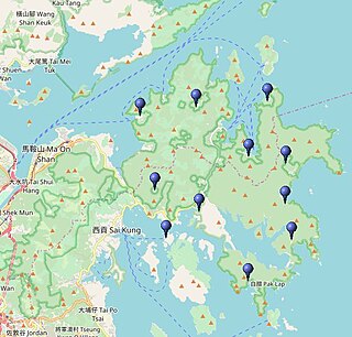
Sai Kung District is one of the 18 districts of Hong Kong. The district comprises the southern half of the Sai Kung Peninsula, the Clear Water Bay Peninsula in the New Territories and a strip of land to the east of Kowloon. Areas in the district include Sai Kung Town, Hong Kong UNESCO Global Geopark, Tseung Kwan O and over 70 islands of different sizes. The administrative centre had been located in Sai Kung Town until the Sai Kung District Office was relocated to Tseung Kwan O recently. The district's population is concentrated in Tseung Kwan O, as of 2011. In 2011, the district was the third youngest district, with a median age of 39.3. Known as the "back garden of Hong Kong", Sai Kung has been able to retain its natural scenery. Many traditional customs and cultures are still retained in the rural villages.

Big Wave Bay or Tai Long Wan is the name of several bays in Hong Kong:

<span class="mw-page-title-main">Sai Wan</span> Area in Hong Kong Island

Sai Wan, also known as Western district, or simply Western, is an area in Hong Kong Island, Hong Kong that corresponds to Sai Ying Pun, Shek Tong Tsui, Belcher Bay and Kennedy Town. However, Some Hong Kong people consider Kennedy Town as the only part of Sai Wan. It formed part of the City of Victoria. West Point, a former cape where major government structures in Sai Wan are close to, also used to refer to Sai Wan.

Taiwan, officially the Republic of China, is a country in East Asia.

<span class="mw-page-title-main">High Island (Hong Kong)</span> Former island in the southeast of Sai Kung Peninsula in Hong Kong

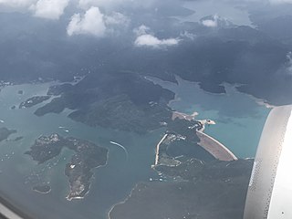
High Island or Leung Shuen Wan Chau is a former island located in the southeast of Sai Kung Peninsula in Hong Kong, within Sai Kung District. Two sets of dams constructed between 1969 and 1979 and crossing the former Kwun Mun Channel (官門海峽), connect the island to the peninsula, thereby forming the High Island Reservoir. Before being connected to the mainland, the island had an area of 8.511 km² (3.29 square miles) and was the 4th largest island of Hong Kong in 1960.

<span class="mw-page-title-main">Shek Pik</span> Area located along the southwestern coast of Lantau Island, Hong Kong.

Shek Pik is an area located along the southwestern coast of Lantau Island, Hong Kong. When the Shek Pik Reservoir was built, villages at Shek Pik were demolished and the villagers were relocated to other parts of Lantau Island and to Tsuen Wan. Below the dam of the reservoir is Shek Pik Prison.

Sai Kung West Country Park is a 30 square kilometres (12 sq mi) country park on the Sai Kung Peninsula in northeast Hong Kong.

Sai Wan is the name or part of the name of several places in Hong Kong.

<span class="mw-page-title-main">Tong lau</span> Type of east asian tenement

Tong lau or ke lau are tenement buildings built from the late 19th century to the 1960s in Hong Kong, Taiwan, Southern China, and Southeast Asia. Designed for both residential and commercial uses, they are similar in style and function to the shophouses with five-foot way of Southeast Asia. Over the years, tong lau construction has seen influences of Edwardian-style architecture and later the Bauhaus movement.

<span class="mw-page-title-main">Big Wave Bay, Hong Kong Island</span> Bay in Hong Kong

Big Wave Bay or Tai Long Wan (大浪灣) is a bay in the Southern District of Hong Kong. It is located on the eastern coast of Hong Kong Island, south of Cape Collinson and north of Shek O. This bay should not be confused with the bay with the same name in Sai Kung.

<span class="mw-page-title-main">Tai Long Wan (Sai Kung District)</span> Bay on the east coast of the Sai Kung Peninsula in Hong Kong

Tai Long Wan is a 3 kilometer-wide bay on the east coast of the Sai Kung Peninsula in Sai Kung District, Hong Kong. Considered one of the most beautiful places in Hong Kong, it is a popular surf destination.

<span class="mw-page-title-main">Hap Mun Bay Beach</span> Beach in Sharp Island, New Territories, Hong Kong

Hap Mun Bay Beach or Half Moon Bay Beach is a gazetted beach located facing Hap Mun Bay in the southern side of Sharp Island, Sai Kung District, Hong Kong. The beach has barbecue pits and is managed by the Leisure and Cultural Services Department of the Hong Kong Government. The beach is 99 metres long and is rated as good to fair by the Environmental Protection Department for its water quality in the past twenty years. There are views of Tai Ngam Hau from the beach.

<span class="mw-page-title-main">Tsam Chuk Wan</span> Bay of the Sai Kung Peninsula in Hong Kong

Tsam Chuk Wan is a bay of the Sai Kung Peninsula in Hong Kong. By extension, it is also the name of the area around the bay. Tsam Chuk Wan Village (斬竹灣村) is one of the villages located within this area.

<span class="mw-page-title-main">Historic churches of Sai Kung Peninsula</span> Historic Churches

The historic churches of Sai Kung are Roman Catholic churches and chapels established in the 19th and 20th centuries by missionaries in the Sai Kung Peninsula and surrounding islands, across modern day administrative areas: the Sai Kung District and Sai Kung North of Tai Po District.

<span class="mw-page-title-main">Tai Tau Chau (Sai Kung District)</span> Island in Sai Kung District, Hong Kong

Tai Tau Chau also known for its less popular name Urn Island, is an island in the water body Sham Tuk Mun (深篤門), Sai Kung District, Hong Kong. Inner Port Shelter and Rocky Harbour are in close proximity to the island.

<span class="mw-page-title-main">Sai Wan Shan (Sai Kung)</span> Mountain of Hong Kong

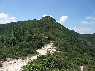
Sai Wan Shan is a hill that lies within Sai Kung East Country Park, south of Tai Long Wan, on the Sai Kung Peninsula in Hong Kong. It has a height of 314 metres (1,030 ft) above sea level. The hill is reasonably easy for hikers and is a popular site for hiking in Hong Kong. A portion of MacLehose Trail Stage 2 is built along the ridge of this hill.

<span class="mw-page-title-main">Trio Beach</span> Beach in Pak Sha Wan Peninsula, New Territories, Hong Kong

Trio Beach is a gazetted beach facing the bay of Sam Sing Wan (三星灣) and located on Pak Sha Wan Peninsula, Sai Kung District, Hong Kong. The beach has barbecue pits and is managed by the Leisure and Cultural Services Department of the Hong Kong Government. The beach is 131 metres long and is rated as good to fair by the Environmental Protection Department for its water quality in the past twenty years.

References

  1. 1 2 "Hong Kong Best 10 Scenic Sites Election Result". FOCP. Retrieved 22 July 2010.
  2. "西貢高危五灘暗湧催命 - 太陽報". the-sun.on.cc. Retrieved 2020-09-24.
  3. "高危大浪西灣秋季藏殺機 - 東方日報". orientaldaily.on.cc. Retrieved 2020-09-24.
  4. "5大危險泳灘 秋冬藏殺機 - 香港文匯報". paper.wenweipo.com. Retrieved 2020-09-24.
  5. "List of Recognized Villages under the New Territories Small House Policy" (PDF). Lands Department. September 2009.
  6. Ho, Teresa (27 July 2010). "大浪灣原居民系列:西灣村以外——咸田村原居民專訪". inmediahk.net (in Chinese).
  7. "Sai Wan Campsite". Agricultural, Fisheries and Conservation Department of the Hong Kong Government. Retrieved 22 July 2010.
  8. "幸福無限 — 西灣海星小堂". thyway.catholic.org.hk (in Chinese). 11 October 2021. Retrieved 18 March 2024.
  9. Christopher DeWolf (10 May 2010). "Summer dreaming: Hong Kong's best beaches". CNN GO. Retrieved 22 July 2010.
  10. 1 2 Krista Mahr (16 July 2010). "In Hong Kong, One Paradise Lost". Time . Retrieved 22 July 2010.
  11. Tiffany Lam (20 July 2010). "Protests over development near one of Hong Kong's best beaches". CNN GO. Retrieved 22 July 2010.
  12. Diana Lee (28 September 2009). "Student feared drowned at Sai Kung beach". The Standard. Archived from the original on 29 June 2011. Retrieved 22 July 2010.
  13. "消防員捨身救人 - 香港文匯報". paper.wenweipo.com. Archived from the original on 2018-12-02. Retrieved 2020-09-28.
  14. "同袍去年曾於現場救人喪命 消防員大浪西灣暢泳溺斃". Apple Daily 蘋果日報 (in Chinese (Hong Kong)). Archived from the original on 2021-06-21. Retrieved 2020-09-28.
  15. "大浪西灣遊船河 中電經理溺斃 - 香港文匯報". paper.wenweipo.com. Archived from the original on 2012-06-22. Retrieved 2020-09-28.
  16. "專題新聞:10呎巨浪捲走理大生 - 太陽報". the-sun.on.cc. Archived from the original on 2010-11-15. Retrieved 2020-09-28.
  17. 頭條日報. "七旬翁西貢大浪西灣遇溺身亡". 頭條日報 Headline Daily (in Chinese). Retrieved 2021-07-18.
  18. 1 2 Cheung Chi-fai (16 July 2010). "It was a pristine picture at Sai Wan, but not any more". SCMP. Retrieved 26 February 2014.
  19. Samuel Chan (21 July 2010). "Beauty spot inaction upsets greens". The Standard. Archived from the original on 29 June 2011. Retrieved 22 July 2010.
  20. http://www.facebook.com/group.php?gid=119731658073048&v=wall [ user-generated source ]
  21. Olga Wong (20 July 2010). "This will give a bad impression". SCMP. Retrieved 26 February 2014.
  22. Olga Wong; Maggie Tam (17 July 2010). "Sai Wan case? I don't know, says minister". SCMP. Retrieved 26 February 2014.
  23. Regina Leung (20 July 2010). "Yau visits controversial Sai Wan project". SCMP. Archived from the original on 21 March 2012. Retrieved 22 July 2010.
  24. Joy Li (21 July 2010). "Green groups to march against 'private lodge' in Sai Wan". China Daily. Retrieved 22 July 2010.
  25. Cheung Chi-fai; Olga Wong; Vivian Li (21 July 2010). Sai Wan not the only site at risk. SCMP.

22°23′57.35″N114°22′24.14″E / 22.3992639°N 114.3733722°E / 22.3992639; 114.3733722