Related Research Articles
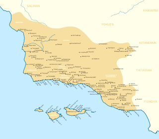
The Chumash are a Native American people of the central and southern coastal regions of California, in portions of what is now Kern, San Luis Obispo, Santa Barbara, Ventura and Los Angeles counties, extending from Morro Bay in the north to Malibu in the south to Mt Pinos in the east. Their territory includes three of the Channel Islands: Santa Cruz, Santa Rosa, and San Miguel; the smaller island of Anacapa was likely inhabited seasonally due to the lack of a consistent water source.

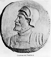
Captain Gaspar de Portolá y Rovira was a Spanish Army officer and colonial administrator who served as the first governor of the Californias from 1767 to 1770. Born in Catalonia into an aristocratic family, he is best known for leading the Portolá expedition into California, which laid the foundations of Spanish rule in the region Californian cities like San Diego and Monterey, and bestowed names to geographic features throughout California, many of which are still in use.
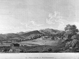
The Presidio of Monterey (POM), located in Monterey, California, is an active US Army installation with historic ties to the Spanish colonial era. Currently, it is the home of the Defense Language Institute Foreign Language Center (DLI-FLC). It is the last and only presidio in California to have an active military installation.

The Conejo Valley is a region spanning both southeastern Ventura County and northwestern Los Angeles County in Southern California, United States. It is located in the northwestern part of the Greater Los Angeles Area.
Pedro Fages (1734–1794) was a Spanish soldier, explorer, first Lieutenant Governor of the province of the Californias under Gaspar de Portolá. Fages claimed the governorship after Portolá's departure, acting as governor in opposition to the official governor Felipe de Barri, and later served officially as fifth (1782–91) Governor of the Californias.

Morro Rock is a volcanic plug in Morro Bay, California, on the Pacific Coast at the entrance to Morro Bay harbor. A causeway connects it with the shore, making it a tied island. The rock is protected as the Morro Rock State Preserve.
Ishxenta State Park is an 1,315-acre (532 ha) California state park in the northern region of Big Sur, California, United States. San Jose Creek on the ranch was the site of an Ohlone village for thousands of years. Europeans first visited the site when the Portolá expedition camped at the site for 10 days in the winter of 1769.

The Santa Ynez River is one of the largest rivers on the Central Coast of California. It is 92 miles (148 km) long, flowing from east to west through the Santa Ynez Valley, reaching the Pacific Ocean at Surf, near Vandenberg Space Force Base and the city of Lompoc.

The Portolá expedition was a Spanish voyage of exploration in 1769–1770 that was the first recorded European exploration of the interior of the present-day California. It was led by Gaspar de Portolá, governor of Las Californias, the Spanish colonial province that included California, Baja California, and other parts of present-day Mexico and the United States. The expedition led to the founding of Alta California and contributed to the solidification of Spanish territorial claims in the disputed and unexplored regions along the Pacific coast of North America.
José Francisco Ortega was a New Spanish soldier and early settler of Alta California. He joined the military at the age of twenty-one and rose to the rank of sergeant by the time he joined the Portola expedition in 1769. At the end of his military duty he would be granted land which he named Rancho Nuestra Senora del Refugio near Santa Barbara.

The Nacimiento River is a 64.8-mile-long (104.3 km) river in southern Monterey County and northern San Luis Obispo County, California. A large portion of the river's run is on military reservations. The river's upper reaches are inside Fort Hunter Liggett, Lake Nacimiento is in the middle and the lower reaches are inside Camp Roberts. It is the largest tributary of the Salinas River in terms of streamflow.

Montara State Beach is a beach located in the coastal region of the U.S. state of California, eight miles north of Half Moon Bay on State Route 1. It is operated by the California State Department of Parks and Recreation under the San Mateo Coast Sector Office. It is one of the cleanest beaches in the state and is known for surfing and fishing.

Purisima Creek is an 8.0-mile-long (12.9 km) stream in San Mateo County, California which rises 1.3 miles (2.1 km) north of Sierra Morena, a mountain in the Santa Cruz Mountains, and flows westward to the Pacific Ocean 2.3 miles (3.7 km) south-southeast of Miramontes Point. Much of its watershed has been incorporated in the Purisima Creek Redwoods Open Space Preserve.
Rancho Punta de la Concepcion was a 24,992-acre (101.14 km2) Mexican land grant in the northern Santa Ynez Mountains, in present day Santa Barbara County, California. It was granted by Governor Juan Alvarado in 1837, to Anastacio Carrillo. The grant extended along the Pacific coast from Point Arguello south to Cojo Creek, just east of Point Conception.
Faria, also known as Faria Beach, is an unincorporated community in Ventura County, California, United States. Faria runs 1.32 miles (2.12 km) along the ocean side of California State Route 1, 9 miles (14 km) northwest of Ventura between Ventura and Carpinteria. It is within the Ventura Unified School District and has a Ventura ZIP Code.

This timeline of the Portolá expedition tracks the progress during 1769 and 1770 of the first European exploration-by-land of north-western coastal areas in what became Las Californias, a province of Spanish colonial New Spain. Later, the region was administratively-split into Baja and Alta. The first section of the march was on the Baja California peninsula, and the northern section of the expedition's trail was in today's US state of California.
Miguel Costansó (1741–1814), original name Miquel Constançó, was a Catalan engineer, cartographer and cosmographer. He joined the expedition of exploration of Alta California led by Gaspar de Portolá and Junípero Serra, serving aboard ship as cartographer and on land as engineer.

The Mission Vieja or Misión Vieja or the Old Mission was the first Spanish mission in the San Gabriel Valley. Mission Vieja was built in 1771 by what would become the fathers of the Mission San Gabriel Arcángel. The Mission Vieja site was designated a California Historic Landmark (No.161) on Jan. 11, 1935. The location of Mission Vieja is at what is now the South West corner North San Gabriel Blvd and North Lincoln Ave in Montebello, California. The site has a plaque marker and an El Camino Real Bell. Mission Vieja was the first building in the San Gabriel Valley and Los Angeles County.
Warring Park is a California Historical Landmark as it is the site that Portolà expedition found the Chumash people group known as the Piru Indian tribe August 11, 1769. This site is in the current town of Piru, California in Ventura County. The site became California Historical Landmark number 624 on October 31, 1957. The Site is just west of Piru Creek and north of Lake Piru.

The San Carlos was a Spanish packet boat built in 1767 at San Blas, Mexico. In 1775, under the command of Spanish naval officer and explorer Lieutenant Juan Manuel de Ayala, the San Carlos became the first ship to enter the San Francisco Bay.
References
- ↑ Teggert, Frederick (August 1911). "The Portola Expedition of 1769 - 1770, Diary of Miguel Costanso". Publications of the Academy of Pacific Coast History. 2 (4): 205. Retrieved 21 May 2021.
- 1 2 3 Lynn H. Gamble (2008), The Chumash world at European contact: power, trade, and feasting among complex hunter-gatherers, University of California Press, p. 377, ISBN 978-0-520-25441-1,
... Tajiguas ... probably means 'the basket' ... 42 houses on one side, 37 on the other ... at least 400 - 800 souls ... August of 1769 ... Six years later ... completely abandoned ...