Related Research Articles

The Spanish missions in California formed a series of 21 religious outposts or missions established between 1769 and 1833 in what is now the U.S. state of California. The missions were established by Catholic priests of the Franciscan order to evangelize indigenous peoples backed by the military force of the Spanish Empire. The missions were part of the expansion and settlement of New Spain through the formation of Alta California, expanding the empire into the most northern and western parts of Spanish North America. Civilian settlers and soldiers accompanied missionaries and formed settlements like the Pueblo de Los Ángeles.
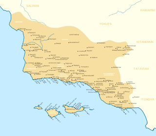
The Chumash are a Native American people of the central and southern coastal regions of California, in portions of what is now San Luis Obispo, Santa Barbara, Ventura and Los Angeles counties, extending from Morro Bay in the north to Malibu in the south. Their territory included three of the Channel Islands: Santa Cruz, Santa Rosa, and San Miguel; the smaller island of Anacapa was likely inhabited seasonally due to the lack of a consistent water source.
José Francisco Ortega was an indigenous Californio soldier and early settler of Alta California. He joined the military at the age of twenty-one and rose to the rank of sergeant by the time he joined the Portola expedition in 1769. At the end of his military duty he would be granted land which he named Rancho Nuestra Senora del Refugio near Santa Barbara.
El Pueblo de Nuestra Señora la Reina de los Ángeles, shortened to Pueblo de los Ángeles, was the Spanish civilian pueblo settled in 1781, which became the American metropolis of Los Angeles. The pueblo was built using labor from the adjacent village of Yaanga and was totally dependent on local Indigenous labor for its survival.

The Tataviam are a Native American group in Southern California. The ancestral land of the Tataviam people includes northwest present-day Los Angeles County and southern Ventura County, primarily in the upper basin of the Santa Clara River, the Santa Susana Mountains, and the Sierra Pelona Mountains. They are distinct from the Kitanemuk and the Gabrielino-Tongva peoples.
The Rancho Nuestra Señora del Refugio was a 74,000-acre (300 km2) Spanish land grant to José Francisco Ortega in 1794 and is the only land grant made under Spanish and confirmed by USA in 1866 to Jose Maria Ortega.under the US Supreme Court rule in what is today Santa Barbara County, California. A Mexican title was granted to Antonio Maria Ortega in 1834 by Mexican Governor José Figueroa. The grant extended along the Pacific coast from Cojo Canyon east of Point Conception, past Arroyo Hondo and Tajiguas Canyon, to Refugio Canyon, including what is now Gaviota Coast.
The history of California can be divided into the Native American period, the European exploration period (1542–1769), the Spanish colonial period (1769–1821), the Mexican Republic period (1823–1848), and United States statehood. California was one of the most culturally and linguistically diverse areas in pre-Columbian North America. After contact with Spanish explorers, many of the Native Americans died from foreign diseases and genocide campaigns.

Felipe de Neve y Padilla was a Spanish soldier who served as the 4th Governor of the Californias, from 1775 to 1782. Neve is considered one of the founders of Los Angeles and was instrumental in the foundation of San Jose and Santa Barbara.
The history of Santa Barbara, California, begins approximately 13,000 years ago with the arrival of the first Native Americans. The Spanish came in the 18th century to occupy and Christianize the area, which became part of Mexico following the Mexican War of Independence. In 1848, the expanding United States acquired the town along with the rest of California as a result of defeating Mexico in the Mexican–American War. Santa Barbara transformed then from a small cluster of adobes into successively a rowdy, lawless Gold Rush era town; a Victorian-era health resort; a center of silent film production; an oil boom town; a town supporting a military base and hospital during World War II; and finally it became the economically diverse resort destination it remains in the present day. Twice destroyed by earthquakes, in 1812 and 1925, it was rebuilt after the second one in a Spanish Colonial style.
Rancho Dos Pueblos was a 15,535-acre (62.87 km2) Mexican land grant in present day Santa Barbara County, California given in 1842 by Governor Juan Alvarado to Nicolas A. Den. The rancho stretched along the Pacific coast to the northwest of today's city of Santa Barbara, from Fairview Avenue in Goleta to the southeastern boundary of today's El Capitan State Beach. A 500-acre parcel was bought by Colin Powys Campbell in 1919. That parcel is now owned by University of California, Santa Barbara which purchased it from the Devereux Foundation in 2007, following the closure of the campus it had established there in 1945.
The history of the San Fernando Valley from its exploration by the 1769 Portola expedition to the annexation of much of it by the City of Los Angeles in 1915 is a story of booms and busts, as cattle ranching, sheep ranching, large-scale wheat farming, and fruit orchards flourished and faded. Throughout its history, settlement in the San Fernando Valley was shaped by availability of reliable water supplies and by proximity to the major transportation routes through the surrounding mountains.
Mikiw was a Native American village of the Chumash people located in the modern-day county of Santa Barbara, California in the United States.
Kuya'mu was a Native American village of the Chumash people located on the Gaviota Coast in the modern-day county of Santa Barbara, California in the United States.
Tajiguas was a Native American village of the Chumash people located on the Gaviota Coast in the County of Santa Barbara, California in the United States.
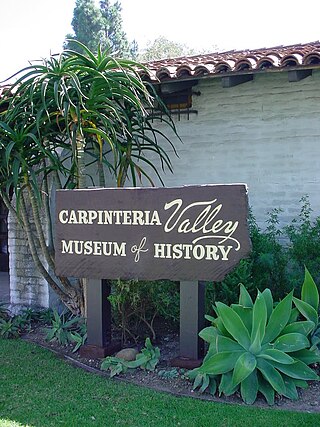
The Carpinteria Valley Museum of History (CVMH) is a museum located in Carpinteria, California. It is operated by the non-profit Carpinteria Valley Historical Society primarily through membership dues, memorial donations, endowment income, and fund-raising activities. The museum is staffed by volunteer docents.

The Chumash revolt of 1824 was an uprising of the Chumash Native Americans against the Spanish and Mexican presence in their ancestral lands. The rebellion began in 3 of the California Missions in Alta California: Mission Santa Inés, Mission Santa Barbara, and Mission La Purisima, and spread to the surrounding villages. All three missions are located in present-day Santa Barbara County, California. The Chumash revolt was the largest organized resistance movement to occur during the Spanish and Mexican periods in California.

This timeline of the Portolá expedition tracks the progress during 1769 and 1770 of the first European exploration-by-land of north-western coastal areas in what became Las Californias, a province of Spanish colonial New Spain. Later, the region was administratively-split into Baja and Alta. The first section of the march was on the Baja California peninsula, and the northern section of the expedition's trail was in today's US state of California.
Humaliwo was a Chumash village located in present-day Malibu, California. “Humaliwo” meant "where the surf sounds loudly". The village occupied a hill across from the lagoon in Malibu Lagoon State Beach.
The Gaviota Coast in Santa Barbara County, California is a rural coastline along the Santa Barbara Channel roughly bounded by the city of Goleta on the south and the north boundary of the county on the north. This last undeveloped stretch of Southern California coastline consists of dramatic bluffs, isolated beaches and terraced grasslands.

Yaanga was a large Tongva village originally located near what is now downtown Los Angeles, just west of the Los Angeles River and beneath U.S. Route 101. People from the village were recorded as Yabit in missionary records although were known as Yaangavit, Yavitam, or Yavitem among the people. It is unclear what the exact population of Yaanga was prior to colonization, although it was recorded as the largest and most influential village in the region.
References
- 1 2 3 Lynn H. Gamble (2008), The Chumash world at European contact: power, trade, and feasting among complex hunter-gatherers, University of California Press, ISBN 978-0-520-25441-1,
... Crespi described an old abandoned village at Refugio when he passed by in 1769 ... apparently resettled by 1776 ... occupied until its inhabitants were recruited into the mission system ...
- ↑ Richard B. Applegate, California State University, San Jose (1974), "Chumash Placenames", The Journal of California Anthropology, 1 (2), retrieved 2009-08-31,
... qasil, a village at EI Refugio, said to mean 'beautiful' in the Dos Pueblos dialect ...
{{citation}}: CS1 maint: multiple names: authors list (link)
|