The Gulf of Finland is the easternmost arm of the Baltic Sea. It extends between Finland to the north and Estonia to the south, to Saint Petersburg in Russia to the east, where the river Neva drains into it. Other major cities around the gulf include Helsinki and Tallinn. The eastern parts of the Gulf of Finland belong to Russia, and some of Russia's most important oil harbors are located farthest in, near Saint Petersburg. As the seaway to Saint Petersburg, the Gulf of Finland has been and continues to be of considerable strategic importance to Russia. Some of the environmental problems affecting the Baltic Sea are at their most pronounced in the shallow gulf. Proposals for a tunnel through the gulf have been made.

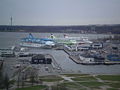
Tallinn is the capital and most populous city of Estonia. Situated on a bay in north Estonia, on the shore of the Gulf of Finland of the Baltic Sea, Tallinn has a population of about 454,000 and administratively lies in the Harju maakond (county). Tallinn is the main governmental, financial, industrial, and cultural centre of Estonia. It is located 187 km (116 mi) northwest of the country's second largest city, Tartu, however only 80 km (50 mi) south of Helsinki, Finland, also 320 km (200 mi) west of Saint Petersburg, Russia, 300 km (190 mi) north of Riga, Latvia, and 380 km (240 mi) east of Stockholm, Sweden. From the 13th century until the first half of the 20th century, Tallinn was known in most of the world by variants of its other historical name Reval.

Aegna is an Estonian island in the Bay of Tallinn in the Baltic Sea. Administratively it is part of the city of Tallinn, the capital of Estonia and is a sub district of the Kesklinn district.

Harju County, is one of the fifteen counties of Estonia. It is situated in Northern Estonia, on the southern coast of the Gulf of Finland, and borders Lääne-Viru County to the east, Järva County to the southeast, Rapla County to the south, and Lääne County to the southwest. The capital and largest city of Estonia, Tallinn, is situated in Harju County. Harju County is the largest county in Estonia in terms of population, as almost half (45%) of the Estonia's population lives in Harju County.
The Nasdaq Tallinn AS, formerly known as the Tallinn Stock Exchange, is a stock exchange operating in Tallinn, Estonia. Nasdaq Tallinn is the only regulated secondary securities market in Estonia. The major stock market index is Nasdaq Tallinn, formerly known as TALSE.

Naissaar is an island in Estonia. It is situated in the Gulf of Finland, northwest of the capital city Tallinn, and is administratively part of the Viimsi parish. The island covers an area of 18.6 square kilometres. It is 8 kilometres long and 3.5 kilometres wide, and lies about 8.5 kilometres from the mainland. The highest point on the island is Kunilamägi, which is 27 metres above sea level. The island consists predominantly of coniferous forest and piles of stones and boulders. In 2020, the island had a population of 17; in 2011 the island had 35 or so permanent residents and some summer residents. Administratively the island is divided into three villages: Lõunaküla (Storbyn), Tagaküla (Bakbyn), and Väikeheinamaa (Lillängin).

The Pirita is a 105 km (65 mi) long river in northern Estonia that drains into Tallinn Bay in Pirita, Tallinn. The basin area of the Pirita is 799 km2.

The Kopli cemetery was Estonia's largest Lutheran Baltic German cemetery, located in the suburb of Kopli in Tallinn. It contained thousands of graves of prominent citizens of Tallinn and stood from 1774 to shortly after World War II, when it was completely flattened and destroyed by the Soviet occupation authorities governing the country at the time. The former cemetery is now a public park.
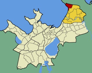
Kopli is a subdistrict of the district of Põhja-Tallinn in Tallinn, the capital of Estonia. It is located on the Kopli Peninsula and is bordered by parts of the Tallinn Bay, the Kopli Bay to the southwest and the Paljassaare Bay to the north. Kopli has a population of 7,240. Kopli's former German name until 1918 was Ziegelskoppel.

Kesklinn is one of the 8 administrative districts of Tallinn, the capital of Estonia. It is situated on the Tallinn Bay and bordered to the northwest by the district of Põhja-Tallinn, to the west by Kristiine, to the southwest by Nõmme, to the east by Lasnamäe and Pirita, and to the south by Rae Parish, beyond Lake Ülemiste. The island of Aegna, located in the Tallinn Bay, also falls within this administrative district. Kesklinn has an area of 30.6 km2 (11.8 sq mi) and a population of 57,731 ; population density is 1,886.6/km2 (4,886/sq mi).
The Kalamaja cemetery, in Tallinn in Estonia was once the city's oldest existing cemetery, located in the suburb of Kalamaja in the north of the city. It contained thousands of graves of ethnic Estonian and Swedish residents of Tallinn and stood for at least 400 years, from the 15th or 16th century to 1964 when it was completely flattened and destroyed by the Soviet occupation authorities governing the country at that time. The former cemetery is now a public park: "Kalamaja kalmistupark".

The Soviet evacuation of Tallinn, also called Juminda mine battle, Tallinn disaster or Russian Dunkirk, was a Soviet operation to evacuate the 190 ships of the Baltic Fleet, units of the Red Army, and pro-Soviet civilians from the fleet's encircled main base of Tallinn in Soviet-occupied Estonia during August 1941. Near Juminda peninsula Soviet fleet ran into minefield that had been laid by the Finnish and German navies, and were repeatedly attacked by aircraft and torpedo boats, suffering massive losses.

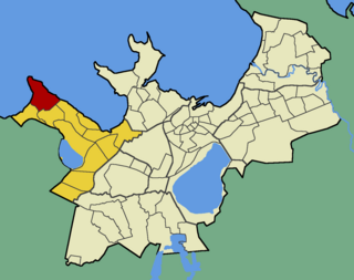
Karjamaa is a subdistrict in the district of Põhja-Tallinn, Tallinn, the capital of Estonia. It's located northwest of Kalamaja and east of Sitsi, main part is between Kopli, Tööstuse and Erika streets. Karjamaa also includes the Hundipea area and the Mine Harbour (Miinisadam) by the Tallinn Bay. Karjamaa has a population of 5,314.

Paljassaare is the name of the Paljassaare Peninsula in the Tallinn Bay, and the name of a subdistrict in the district of Põhja-Tallinn in the city of Tallinn, the capital of Estonia. The subdistrict is located on the peninsula.

Pelguranna is a subdistrict in the district of Põhja-Tallinn in Tallinn, the capital of Estonia. It is located between Pelgulinn, Kopli and Sitsi and is bordered with the Stroomi Beach by the Kopli Bay to the west, and the Merimets forest park to the south. Houses there mostly consist of 4-9 floor apartment buildings. Pelguranna has a population of 15,142.
Merivälja is a subdistrict in the district of Pirita, Tallinn, the capital of Estonia. It is located on the eastern coast of the Tallinn Bay, and is the northernmost subdistrict of Tallinn. Merivälja has a population of 3,088. It is the wealthiest subdistrict of the district of Pirita.

Pirita is a subdistrict in the district of Pirita, Tallinn, the capital of Estonia. It is located around the estuary of the Pirita River to the Tallinn Bay. The subdistrict has a population of 960. Pirita was selected as the venue of the sailing events for the 1980 summer Olympics. During the preparations for the Olympics, sports buildings were built in Tallinn including the Pirita Yachting Centre and the Hotel Olümpia.

Maarjamäe is a subdistrict in the district of Pirita, Tallinn, the capital of Estonia. It is bordered by Pirita and Kose to the north, Lasnamäe to the south, Kadriorg to the southwest and the Bay of Tallinn to the west. As of 2022, it has a population of 2,412.
Kakumäe is a subdistrict in the district of Haabersti, Tallinn, the capital of Estonia. It is located at the top of the Kakumäe Peninsula, which is part of the Baltic Klint in the Tallinn Bay. Kakumäe has a population of 1,733 and is one of the wealthiest regions in Estonia.
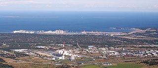
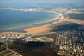
Muuga Harbour is the largest cargo port in Estonia, located on the southern coast of the Gulf of Finland, 17 kilometres (11 mi) northeast of the capital Tallinn, in Maardu. The harbour is administrated by Port of Tallinn, the biggest port authority in Estonia. Muuga Harbour is one of the few ice-free ports in northernmost Europe and among the deepest —up to 18 metres (59 ft) — and most modern ports in the Baltic Sea region. The cargo volume handled accounts for around 80% of the total cargo volume of Port of Tallinn and approximately 90% of the transit cargo volume passing through Estonia. Nearly 3/4 of cargo loaded in Muuga Harbour includes crude oil and oil products, but the harbour also serves dry bulk and other types of cargo.