Tambogo | |
|---|---|
 Tambogo Location within Burkina Faso, French West Africa | |
| Coordinates: 12°18′55.13″N0°23′52.17″W / 12.3153139°N 0.3978250°W | |
| Country | |
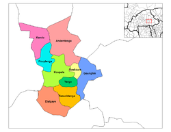
| Province | Kouritenga |
| Department | Andemtenga |
| Population (2006) | |
• Total | 2,403 |
| Time zone | UTC+0 (GMT) |
Tambogo, also known as Tambogo I and II, [1] is a commune in the Andemtenga Department of Kouritenga Province in the Centre-Est region of Burkina Faso. It had a population of 2,403 in 2006. [2] [3]
Contents
The town contains a school, Tambogo Primary School, which opened on 1 October 1986. [4] [5] It also contains a private pharmacy, WEDA Wendyam Cathérine, which opened in 2011. [6]