Toesse-Koulba

Last updated
Toesse-Koulba
Burkina Faso location map.svg
Red pog.svg
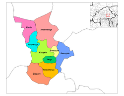
Toesse-Koulba
Location within Burkina Faso, French West Africa
Coordinates: 11°48.9′N0°17.1′W / 11.8150°N 0.2850°W / 11.8150; -0.2850
CountryFlag of Burkina Faso.svg  Burkina Faso
Province Kouritenga
Department Dialgaye
Elevation
309 m (1,014 ft)
Population
 (2006)
  Total
815
Time zone UTC+0 (GMT)

Toesse-Koulba, also spelt Toessin-Koulouba, [1] is a commune in the Dialgaye Department of Kouritenga Province in the Centre-Est region of Burkina Faso. It had a population of 815 in 2006. [2] [3]

Contents

Demographics

YearPopulation
1985554 [4]
1996851 [5]
2006815 [2] [3]

Neighbourhoods

NeighbourhoodPopulation (2006) [2]
Bagawenéghin58
Goghin156
Laknoghin72
Natenga90
Saabin63
Silmissin135
Tanpingou163
Zapnamin77

References

  1. "Burkina Faso Observatoire du Sahara et du Sahel Atlas des Cartes d'Occupation du Sol" (PDF). September 2015. Archived from the original (PDF) on 2017-03-12. Retrieved 10 March 2017.
  2. 1 2 3 "Résultats de l'Inventaire National des Ouvrages d'Approvisionnement ..." Retrieved 11 March 2017.
  3. 1 2 "MEMORANDUM SUR LA DETERMINATION DU NOMBRE DE SIEGES DES CONSEILLERS MUNICIPAUX PAR VILLAGES ET PAR SECTEURS DANS LE CADRE DES ELECTIONS LOCALES DU 02 DECEMBRE 2012" (PDF). Ouagadougou. 11 September 2012. Archived from the original (PDF) on 2012-09-16. Retrieved 10 March 2017.
  4. "RECENSEMENT GENERAL DE LA POPULATION - 1985 • Structure par âge et sexe des villages du Burkina Faso DEUXIEME EDITION" (PDF). MINISTERE DU PLAN ET DE LA COOPERATION; INSTITUT NATIONAL DE LA STATISTIQUE ET DE LA DEMOGRAPHIE; DIRECTION DE LA DEMOGRAPHIE. 1985.
  5. "Listes des Villages de la Region du Centre Est". Archived from the original on 2013-12-24. Retrieved 2017-03-10.