
Wroclaw Voivodeship was a unit of administrative division and local government in Poland in years 1975–1998, superseded by Lower Silesian Voivodeship. Its capital city was Wrocław.

In geology, the places known as hotspots or hot spots are volcanic regions thought to be fed by underlying mantle that is anomalously hot compared with the surrounding mantle. Examples include the Hawaii, Iceland and Yellowstone hotspots. A hotspot's position on the Earth's surface is independent of tectonic plate boundaries, and so hotspots may create a chain of volcanoes as the plates move above them.

Oviedo is one of 8 comarcas of the province and autonomous community of Asturias in Spain.

Proaza is a municipality in the Autonomous Community of the Principality of Asturias, Spain. It is bordered on the north by Santo Adriano and Grado, on the south by Teverga and Quirós, on the west by Yernes y Tameza and Teverga, and on the east by Quirós.

Zucchelli Station is an Italian seasonal research station, located at Terra Nova Bay in Antarctica on a granitic headland along the coast of the Northern Foothills to north-east of Gerlache Inlet. It has been named after Mario Zucchelli, director of the activities, which conducted for sixteen years, for the ENEA-Unità Tecnica Antartide as part of the National Antarctic Research Program (PNRA).

The Narcea is a river of Asturias. It is a tributary of the Nalón River.
Daya is a village on the Zanzibari island of Pemba in Tanzania. It is located in the northwest of the island, four kilometres south of Wete.
Somao is one of fifteen parishes in Pravia, a municipality within the province and autonomous community of Asturias, in northern Spain.
Villazón is one of 28 parishes in Salas, a municipality within the province and autonomous community of Asturias, in northern Spain.

Corés is one of fifteen parishes in Somiedo, a municipality within the province and autonomous community of Asturias, in northern Spain.
San Salvador d'Alesga is one of thirteen parishes in Teverga, a municipality within the province and autonomous community of Asturias, in northern Spain. The Castillo de Alesga is located in San Salvador d'Alesga.
Yernes is one of two parishes in Yernes y Tameza, a municipality within the province and autonomous community of Asturias, in northern Spain.
Metropolitan Białystok - a metropolitan area designated by the Governor of the Regulation No. 52/05 of 16 May 2005 in order to help economically develop the region.

ZawkrzeZawkrze Land, is a small historic region of Poland (ziemia), located in northern Mazovia, along the border with Masuria. Its approximate area is 1,784 km2 (689 sq mi), and the population is about 114,000. Currently, Zawkrze has three towns, and more than 200 villages. Its name comes from the Wkra river – Zawkrze means the land behind the Wkra, from the perspective of Płock, historic capital of Mazovia. The largest town of the region is Mława, while historic capital of Zawkrze is Szreńsk.
Lahoua Smaïl Stadium is a multi-use stadium in Tadjenanet, Algeria.It is currently used mostly for football matches stadium is the home ground of DRB Tadjenanet. The stadium holds 9,000 spectators.

Caldoveiro Peak is a protected mountain range in Asturias, Northern Spain, with a maximum peak of 1,357 meters, near the village of Villabre. It spans the parishes of Yernes, Proaza, Tameza, Grau (Grado), and Teberga (Teverga). Minerals found in Caldoveiro mines include Fluorite, Calcite, and Quartz. The Asturian administration uses Caldoveiro Peak in its tourism advertising, describing the mountain range as so:
The varied vegetation of this nature area and the different processes of erosion that sculpt contrasting terrain form a picturesque landscape dotted with small mountain lakes and high pastures with stone huts known as corros.

The 2018 Atlantic hurricane season was an event in the annual hurricane season in the north Atlantic Ocean. It as an above-average season for tropical cyclones for the third consecutive year. Though the season officially began on June 1, 2018 and ended November 30, 2018, dates adopted by convention and historically describe the period during each year when most tropical cyclones form, it effectively started with the formation of Tropical Storm Alberto on May 25. The season's final storm, Hurricane Oscar, dissipated on October 31.
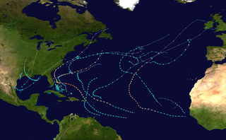
The 2019 Atlantic hurricane season was an event in the annual tropical cyclone season in the north Atlantic Ocean. It was the fourth consecutive above-normal Atlantic hurricane season. The season officially began on June 1, 2019 and ended on November 30, 2019. These dates, adopted by convention, historically describe the period in each year when most tropical systems form. However, storm formation is possible at any time of the year, as demonstrated in 2019 by the formation of the season's first named storm, Subtropical Storm Andrea, on May 20. The final storm of the season, Tropical Storm Sebastien, transitioned to an extratropical cyclone on November 25.
Panormus or Panormos was a small port town of ancient Caria, on the peninsula of Halicarnassus, 80 stadia to the northeast of Myndus. It is no doubt the same port which Thucydides calls Πάνορμος τῆς Μιλησίας.
