Caso is a municipality in the Spanish Principality of Asturias. It shares a boundary to the North with Piloña; to the East with Ponga; to the South with León and to the West with Sobrescobio and Laviana.

Aller is a municipality in the Autonomous Community of the Principality of Asturias, Spain. It is bordered on the north by Mieres, on the south by the province of León, on the east by Laviana, Caso, and Sobrescobio, and on the west by Lena.

Belmonte de Miranda is a municipality in the Autonomous Community of the Principality of Asturias, Spain. It is bordered on the north by Salas, on the east by Grado, to the south by Somiedo and Teverga, and on the west by Tineo.
Teverga is a municipality in the Autonomous Community of the Principality of Asturias, Spain. It is bordered on the north by Belmonte de Miranda, Grado, Yernes y Tameza, and Proaza; to the south by León province, to the west by Somiedo and to the east by Quirós and Proaza.
Grandas de Salime is a municipality in the Autonomous Community of the Principality of Asturias, Spain. It is famous for its hydroelectric dam across the Navia River, forming the Embalse de Salime. It is also famous for being a stop along the Camino Primitivo path of the Camino de Santiago, where it is the last stretch of Asturian land before the entrance into Galicia through the Acebo Pass.
Grado is a municipality in the Autonomous Community of the Principality of Asturias in Spain. It is bordered on the north by Candamo and Las Regueras, on the east by Proaza, Santo Adriano and Oviedo, on the south by Teverga and Yernes y Tameza, and on the west by Belmonte de Miranda and Salas.

Proaza is a municipality in the Autonomous Community of the Principality of Asturias, Spain. It is bordered on the north by Santo Adriano and Grado, on the south by Teverga and Quirós, on the west by Yernes y Tameza and Teverga, and on the east by Quirós.

Ribera de Arriba is a municipality in the Autonomous Community of the Principality of Asturias, Spain. It is bordered on the north and east by Oviedo, on the south by Mieres and Morcín, and on the west by Santo Adriano. As of 2010, it has a population of 2,009.

Candamo is a municipality in the Autonomous Community of the Principality of Asturias, Spain. It is bordered on the east by Las Regueras, on the south by Grado, on the north by Illas, Castrillón and Soto del Barco, and on the west by Pravia and Salas.
Cuaña is a municipality in the Autonomous Community of the Principality of Asturias, Spain. It lies along the Cantabrian Sea to the north, and is bordered on the south by Boal, on the east by Navia and Villayón across the Navia River, and on the west by El Franco.
Las Regueras is a municipality in the Autonomous Community of the Principality of Asturias, Spain. It is bordered on the north by Illas and Llanera, on the south by Grado, on the west by Candamo, and on the east by Oviedo and Llanera.

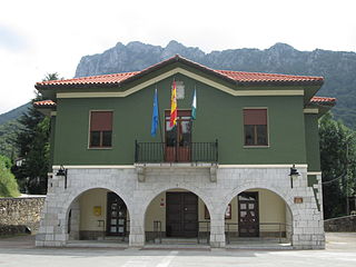
Sobrescobio is a municipality in the Autonomous Community of the Principality of Asturias, Spain. It is bordered on the north by Piloña, on the east by Caso, on the south by Aller, and on the west by Laviana. It is situated in the southeast section of Asturias, at the eastern limit of the Nalón mineral basin.
Santo Adriano is a municipality in the Autonomous Community of the Principality of Asturias. It is bordered on the north by Oviedo, on the east by Ribera de Arriba and Morcín, on the south by Quirós and Proaza and on the west by Proaza and Grado.

Caravia is a municipality in the Autonomous Community of the Principality of Asturias, Spain. It is bordered on the north by the Bay of Biscay, part of the Cantabrian Sea, on the south by Parres, on the east by Ribadesella and on the west by Colunga.

Tameza is one of two parishes in Yernes y Tameza, a municipality within the province and autonomous community of Asturias, in northern Spain.

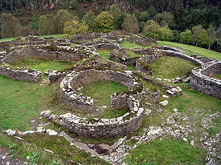
Old Common Council of Castropol, also Eo-Navia Land, Entrambasauguas or Honor de Suarón and Grandas is the name that was historically given to the sixteen westernmost villages of Asturias located between the Eo and Navia rivers. These villages belonged to the sixth sección or party that made up the Junta General del Principado, the historical governing body of Asturias. Episcopalías was composed by the following villages or concejos: Castropol, Rivera de Abajo, Rivera de Arriba, Langreo, Llanera, Quirós, Teverga, Noreña, Las Regueras, Navia, Morcín, Tudela, Proaza, Santo Adriano, Pajares, Riosa, Olloniego, Yernes y Tameza, Bimenes, Paderni, Sobrescobio and Peñaflor.

The 1995 Asturian regional election was held on Sunday, 28 May 1995, to elect the 4th General Junta of the Principality of Asturias. All 45 seats in the General Junta were up for election. The election was held simultaneously with regional elections in twelve other autonomous communities and local elections all throughout Spain.

The 2003 Asturian regional election was held on Sunday, 25 May 2003, to elect the 6th General Junta of the Principality of Asturias. All 45 seats in the General Junta were up for election. The election was held simultaneously with regional elections in twelve other autonomous communities and local elections all throughout Spain.

Caldoveiro Peak is a protected mountain range in Asturias, Northern Spain, with a maximum peak of 1,357 meters, near the village of Villabre. It spans the parishes of Yernes, Proaza, Tameza, Grau (Grado), and Teberga (Teverga). Minerals found in Caldoveiro mines include Fluorite, Calcite, and Quartz. The Asturian administration uses Caldoveiro Peak in its tourism advertising, describing the mountain range as so:
The varied vegetation of this nature area and the different processes of erosion that sculpt contrasting terrain form a picturesque landscape dotted with small mountain lakes and high pastures with stone huts known as corros.
The COVID-19 pandemic in Asturias was part of the Spanish outbreak of the worldwide COVID-19 pandemic.


