Taramundi

Last updated
Taramundi
Town of Taramundi.JPG
Escudo de Taramundi.gif
Taramundi Asturies map.svg
Spain location map with provinces.svg
Red pog.svg
Taramundi
Location in Spain
Coordinates: 43°21.7′N7°6.5′W / 43.3617°N 7.1083°W / 43.3617; -7.1083
CountryFlag of Spain.svg  Spain
Autonomous community Flag of Asturias.svg  Asturias
Province Asturias
Comarca Eo-Navia
Capital Taramundi
Government
   Alcalde Eduardo Lastra Pérez (PSOE)
Area
  Total82.16 km2 (31.72 sq mi)
Highest elevation
1,033 m (3,389 ft)
Population
 (2018) [1]
  Total646
  Density7.9/km2 (20/sq mi)
Demonym taramundés
Time zone UTC+1 (CET)
  Summer (DST) UTC+2 (CEST)
Postal code
33775
Website Official website

Taramundi is a municipality in the Principality of Asturias, Spain. It neighbors on the north side with San Tirso de Abres and Vegadeo, on the east side with Villanueva de Oscos and Vegadeo, on the south side with Santa Eulalia de Oscos and A Pontenova (Lugo), and on the west side with Lugo.

Contents

It is one of Eonavian speaking councils of Asturias. [2]

Population

Taramundi
From: INE Archiv

Parishes

Taramundi and the Turia Valley

Taramundi is part of the Turía Valley or “Valle del Turía”, a small valley on the western border of the Cantabrian Mountains in the northwest of Spain which is close to beaches and is divided by two counties: Asturias and Galicia. It consists of an area of 90 km2 (35 sq mi), 3910 inhabitants and is 200 m (660 ft) above sea level. There are two main towns are A Pontenova (Galicia) and Taramundi (Asturias).

The climate in the region is pleasant throughout the year. As with the rest of northern Spain, the climate is more variable than the southern parts of Spain and is characterised by an Atlantic climate. The average temperature in summer is usually around 26 °C (79 °F). The average temperature in winter is 8 °C (46 °F); 12 °C (54 °F) in the day and 4 °C (39 °F) at night.

The Turía River gives its name to the valley. The valley is surrounded by hills and mountains, including, Sierra de Piedrafita (900 m, 3,000 ft), Sierra de Ouroso (1,033 m, 3,389 ft), Sierras de Dendin (900 m, 3,000 ft), Sierra de Teixedais (900 m, 3,000 ft) and Sierra de Eirua (700 m, 2,300 ft).

UNESCO Biosphere Reserve

Also Taramundi is part of the Eo River, Oscos and Buron lands Biosphere Reserve. A Biosphere Reserve is an international conservation designation given by UNESCO under its Programme on Man and the Biosphere (MAB). The World Network of Biosphere Reserves is the collection of all 531 biosphere reserves in 105 countries (as of May, 2008). Biosphere reserves are created to promote and demonstrate a balanced relationship between humans and the biosphere. The area included in the Biosphere Reserve occupies a surface of 158,883 hectares (392,610 acres) of which 215 km2 (83 sq mi) belongs to the area of the Turía Valley.

Agriculture, fish farming and tourism are the principal areas of growth for the region. Although there has been a fall in the primary sector in recent years and an increase in the service sectors as rural tourism , agriculture still remains the largest economical activity of local economy.

Micro businesses and family run businesses are very characteristic of the region. Construction, commerce, hotels and rural tourism also account for high percentage of local business.

Rural tourism is now a growing activity in all the Reserve, at present there are about 170 establishments catered for rural tourism.

Turía River

The Río Turía ("Turia River") is a small river which rises in the town of Taramundi (Asturias) and drains into the Eo River in the town of A Pontenova (Lugo).

The Turia river gives its name to the Turia Valley or “Valle del Turía” that crosses horizontally before emptying into the Eo river. The Turia river is fed by numerous streams and creeks from the mountains that limit the valley, and is part of the Eo UNESCO biosphere reserve.

While the river is born in Asturias, the bulk of his wealth is found in Lugo (Galicia).

The Turia river is a source of industry and its waters are used to generate socio-economic activities based on ancient traditions such as Navajeros crafts and textiles, as well as the primary industry of salmon farming in A Pontenova (Lugo).

Related Research Articles

<span class="mw-page-title-main">Sierra Nevada (Spain)</span> Mountain range in southern Spain

Sierra Nevada is a mountain range in the Andalusian province of Granada in Spain. It contains the highest point of continental Spain: Mulhacén, at 3,479 metres (11,414 ft) above sea level.

<span class="mw-page-title-main">Sierra Nevada de Santa Marta</span> Mountain range in northern Colombia

The Sierra Nevada de Santa Marta is an isolated mountain range in northern Colombia, separate from the Andes range that runs through the north of the country. Reaching an elevation of 5,700 m (18,700 ft) just 42 km (26 mi) from the Caribbean coast, the Sierra Nevada is the highest coastal range in the tropics, and one of the highest coastal ranges in the world, being 250 metres (820 ft) shorter than the Saint Elias Mountains in Canada. The Sierra Nevada encompasses about 17,000 km2 (6,600 sq mi) and serves as the source of 36 rivers. The range is in the Departments of Magdalena, Cesar and La Guajira.

<span class="mw-page-title-main">Castropol</span> Municipality in Asturias, Spain

Castropol is a municipality in Asturias, Spain. It is also the name of a parish within the municipality and a town within the parish.

<span class="mw-page-title-main">Castroverde</span> Municipality in Lugo, Spain

Castroverde is a municipality in the province of Lugo, in the autonomous community of Galicia, Spain. It belongs to the comarca of Lugo.

<span class="mw-page-title-main">Minho (river)</span> River in Portugal and Spain

The Minho or Miño is the longest river in Galicia, with a length of 340 kilometres (210 mi). It forms part of the international border between Spain and Portugal. By discharge volume, it is the fourth largest river of the Iberian peninsula after the Douro, Ebro, and Tagus rivers.

<span class="mw-page-title-main">Serra dos Ancares</span>

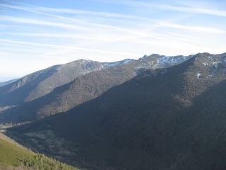
The Serra dos Ancares is a mountain range of the Galician Massif in north-west Spain, extending in a south-westerly direction from the western end of the Cantabrian Mountains in Asturias.

<span class="mw-page-title-main">Vegadeo</span> Municipality in Asturias, Spain

Vegadeo is a municipality in the Autonomous Community of the Principality of Asturias, Spain. It is bordered in the north and east by Castropol, in the south by Villanueva de Oscos, Taramundi, and San Tirso de Abres, and in the west by the Eo River and San Tirso.

<span class="mw-page-title-main">San Tirso de Abres</span> Municipality in Asturias, Spain

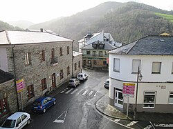
San Tirso de Abres is a municipality in the Autonomous Community of the Principality of Asturias, Spain. It is bordered on the north, south, and west by Lugo province of Galicia, and on the east by the municipalities of Taramundi and Vegadeo. It is the westernmost council in Asturias.

<span class="mw-page-title-main">Grandas de Salime</span> Municipality in Asturias, Spain

Grandas de Salime is a municipality in the Autonomous Community of the Principality of Asturias, Spain. It is famous for its hydroelectric dam across the Navia River, forming the Embalse de Salime. It is also famous for being a stop along the Camino Primitivo path of the Camino de Santiago, where it is the last stretch of Asturian land before the entrance into Galicia through the Acebo Pass.

<span class="mw-page-title-main">Galician–Asturian</span> Romance dialects in a Galician/Portuguese–Asturian continuum

Galician–Asturian or Eonavian is a set of Romance dialects or falas whose linguistic dominion extends into the zone of Asturias between the Eo River and Navia River. The dialects have been variously classified as the northeastern varieties of Galician, as a linguistic group of its own, or as a dialect of transition between Galician and Asturian, an opinion upheld by José Luis García Arias, the former president of the Academy of the Asturian Language (ALLA).

Samos is a municipality in the province of Lugo in the autonomous community of Galicia, Spain. It belongs to the comarca of Sarria.

<span class="mw-page-title-main">Eo (river)</span> River in Spain

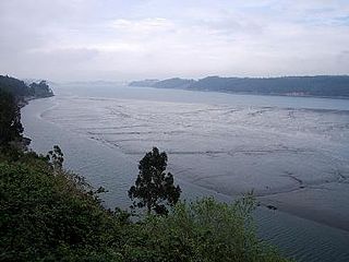
The Eo is a river, 91 kilometres (57 mi) long, in northwestern Spain. Its estuary forms the boundary between the regions of Galicia and Asturias. The river is known for its salmon fishing.

<span class="mw-page-title-main">A Pontenova</span> Municipality in Galicia, Spain

A Pontenova is a municipality in the province of Lugo, in the autonomous community of Galicia, Spain. It belongs to the comarca of A Mariña Oriental. It has a population of 3199 and an area of 136 km².

<span class="mw-page-title-main">Fernando Villapol</span>

Fernando Villapol Parapar is a museum curator and art critic, most famous as a contemporary Galician sculptor. He currently lives and works in the town of Bretoña (Lugo) located in Galicia. He is also the founder of the Ethnographic-Pedagogic Museum in Bretoña. He studied at the College of Applied Arts in Lugo, Spain, although can be considered an autodidact, attributing most of his knowledge and acquired skills through his self-funded travels and investigations of sculpture across the globe.

<span class="mw-page-title-main">As Veigas</span>

As Veigas is one of four parishes in Taramundi, a municipality within the province and autonomous community of Asturias, in northern Spain.

<span class="mw-page-title-main">Turía (river)</span> River in Spain

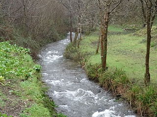
The Turía is a small river in Galicia, Spain. It is 9 kilometres (6 mi) long, and its mouth is at an elevation of 250 metres (820 ft) above the sea. It rises in the town of Taramundi (Asturias) and drains into the Eo River in the town of A Pontenova.

<span class="mw-page-title-main">Turia Valley</span>

The Turia Valley is a small valley on the western border of the Cantabrian Mountains in the northwest of Spain which is close to beaches and is divided by two autonomous communities: Asturias and Galicia. It consists of an area of 90 km2, 3,910 inhabitants and is 200 m above sea level. The two main towns are A Pontenova (Galicia) and Taramundi (Asturias).

<span class="mw-page-title-main">Mazonovo</span> Village in Asturias, Spain

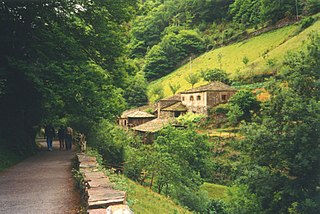
Mazonovo is a former town and now a museum in the municipality of Taramundi, Asturias, Spain. It is located between the Cabreira River and the Turía River, southeast of the town of Taramundi, northwest of Veigas, and 183 km (114 mi) from Oviedo, the capital of Asturias. According to the census of 2005, the population is four people.

<span class="mw-page-title-main">Sierras de Cazorla, Segura y Las Villas Natural Park</span>

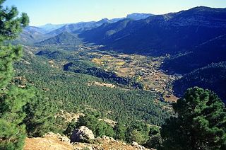
Sierras de Cazorla, Segura y Las Villas Natural Park is a natural park in the eastern and northeastern part of the province of Jaén, Spain, established in 1986. With an area of 2,099.2 square kilometres (810.5 sq mi), it is the largest protected area in Spain and the second largest in Europe. It was declared a biosphere reserve by UNESCO in 1983 and also a Special Protection Area for migratory birds in 1988.

<span class="mw-page-title-main">Galician Massif</span>

The Galician Massif is a system of mountain ranges in the northwestern corner of the Iberian Peninsula. It is located in Galicia with its southeastern end reaching into the provinces of Zamora and León of Castile and León. Its highest point is Pena Trevinca at 2,127 metres (6,978 ft). Another important peak is Cabeza de Manzaneda.

References

  1. Municipal Register of Spain 2018. National Statistics Institute.
  2. Multilingualism in Spain. Teresa Turell. page 113