Asturias officially the Principality of Asturias, is an autonomous community in northwest Spain.

Cantabria is an autonomous community and province in northern Spain with Santander as its capital city. It is called a comunidad histórica, a historic community, in its current Statute of Autonomy. It is bordered on the east by the Basque autonomous community, on the south by Castile and León, on the west by the Principality of Asturias, and on the north by the Cantabrian Sea, which forms part of the Bay of Biscay.

León is a province of northwestern Spain in the northern part of the Region of León and in the northwestern part of the autonomous community of Castile and León.

Cangas de Onís is a municipality in the eastern part of the province and autonomous community of Asturias in the northwest of Spain. The capital of the municipality is also Cangas de Onís.
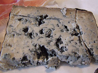
Cabrales is a blue cheese made in the artisan tradition by rural dairy farmers in Asturias, Spain. This cheese can be made from pure, unpasteurized cow’s milk or blended in the traditional manner with goat and/or sheep milk, which lends the cheese a stronger, spicier flavor.

The Picos de Europa are a mountain range extending for about 20 km (12 mi), forming part of the Cantabrian Mountains in northern Spain. The range is situated in the Autonomous Communities of Asturias, Cantabria and Castile and León. The highest peak is Torre de Cerredo, at an elevation of 2650 m (8,690 ft).

Llanes is a municipality of the province of Asturias, in northern Spain. Stretching for about 30 km along the coast at the extreme east of the province, Llanes is bounded to the south by the high ridge of the limestone Sierra del Cuera, which rises to over 1,100 m. The region is part of the Costa Verde of Spain, which is known for its spectacular coastal scenery, with 32 white sand beaches, and mountains covered with a deep green mantle. Llanes lies to the north of the Picos de Europa, a mountain range whose geology is almost entirely of limestone karst.

Siero is a municipality of the autonomous community of Asturias, in northern Spain. With a population of 52,194 as of 2023, Siero is the fourth most populous municipality in Asturias. It has a total of 29 parishes, with the largest being Lugones; its capital parish is La Pola Siero. It is located centrally within Asturias, and the northernmost point of Siero is about 10 km from Asturias' largest city, Gijón, and the shores of the Cantabrian Sea.
The Battle of El Mazucu was fought between 6 and 22 September 1937, between the Republican and Nationalist armies during the Spanish Civil War as a part of the War in the North campaign. The Republican defence of El Mazucu and the surrounding mountains halted the Nationalist advance into eastern Asturias, despite their forces being outnumbered sevenfold. After weeks of intense fighting over extreme terrain the defenders were eventually overwhelmed, and the Nationalists were then able to link up with their forces advancing from León, leading to the fall of Gijón and the abandonment of Asturias, the last Republican province in North-West Spain.
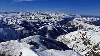
The Cantabrian Mountains or Cantabrian Range are one of the main systems of mountain ranges in Spain. They stretch for over 300 km (180 miles) across northern Spain, from the western limit of the Pyrenees to the Galician Massif in Galicia, along the coast of the Cantabrian Sea. Their easternmost end meets the Sistema Ibérico.

Onís is a municipality in the autonomous community of Asturias, Spain. As of 2023, the population of the municipality equaled 746. Onís is bordered on the north by Llanes, on the south by the province of León, to the east by Cabrales and to the west by Cangas de Onís. The area of the municipality is 75 km2, with more than a third of its territory falling within Picos de Europa National Park. the Pico de Verdilluenga, one of the peaks of the Picos de Europa, is the highest point in the municipality, standing at 2,129 m. The municipality comprises three parishes:
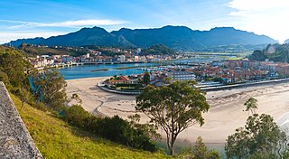
Ribadesella is a small 84-square-kilometre (32 sq mi) municipality in the Autonomous Community of the Principality of Asturias, Spain. Known for its location on the Cantabrian Sea, at the outlet of the River Sella, Ribadesella is a town that forms part of the Picos de Europa. It is bordered on the east by Llanes, on the south by Cangas de Onís and Parres, and on the west by Caravia. Ribadesella is the home town of Queen Letizia of Spain.

Peñamellera Baja is a municipality in the Autonomous Community of the Principality of Asturias, Spain. It is borderered to the north by Llanes and Ribadedeva, to the west by Peñamellera Alta, and to the east and south by the Autonomous Community of Cantabria.
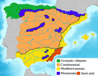
Cantabrian Coast is the name given to a lush natural region in Northern Spain, stretching along the Atlantic coast from the border with Portugal to the border with France. The region includes nearly all of Galicia, Asturias, and Cantabria, in addition to the northern parts of the Basque Country, as well as a small portion of Navarre.

The Naranjo de Bulnes is a limestone peak dating from the Paleozoic Era, located in the Macizo Central region of the Picos de Europa, Asturias (Spain). Its name Picu Urriellu is believed to be derived from the term Los Urrieles, which is used to describe the Macizo Central. Naranjo de Bulnes is part of the Cabrales region of Asturias, and lies within the Picos de Europa National Park.

The Picos de Europa National Park is a National Park in the Picos de Europa mountain range, in northern Spain. It is within the boundaries of three autonomous communities, Asturias, Cantabria and Castile and León, which are represented on the body which runs the park. The park is also a popular destination for hikers and trekkers.

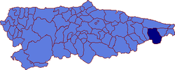
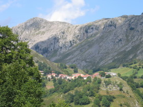
Sotres is a village and parish in the Asturian municipality of Cabrales, in Spain, located 19 km from Carreña, the municipal capital, in the eastern extreme of the province.

Sierra de Cuera, is a 30 km long mountain chain of the Cantabrian Mountains. The ridge's highest point is Pico Turbina. This mountain range is located at 6 km from the sea and runs parallel to the coast. It lies within the Cabrales, Llanes, Peñamellera Alta, Peñamellera Baja and Ribadedeva municipal terms.

Potes is a municipality in the autonomous community of Cantabria in Spain. It is the capital of the Comarca of Liébana and is located in the centre of it. It is bordered to the north by Cillorigo de Liébana, to the west by Camaleño, to the south by Vega de Liébana and to the east by Cabezón de Liébana.

The Urrieles Massif or the Central Massif is a mountainous massif in the north of Spain, one of the three massifs that make up the Picos de Europa, and in turn, one of the stretches of the Cantabrian Massif belonging to the Cantabrian Range. The other two massifs are the Cornión and Ándara. Of the three, it is the tallest. The unique formation of the massif is the result of glacial activity.