Related Research Articles

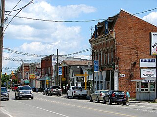
Belleville is a city in Ontario, Canada situated on the eastern end of Lake Ontario, located at the mouth of the Moira River and on the Bay of Quinte. Belleville is between Ottawa and Toronto, along the Quebec City-Windsor Corridor. Its population as of the 2016 census was 50,716. It is the seat of Hastings County, but politically independent of it, and is the centre of the Bay of Quinte Region.

Newmarket is a town and regional seat of the Regional Municipality of York in the Canadian province of Ontario. It is part of Greater Toronto in the Golden Horseshoe region of Southern Ontario. The name stems from the fact that the settlement was a "New Market", in contrast to York as the Old Market.

Etobicoke is an administrative district of, and one of six municipalities amalgamated into, the city of Toronto, Ontario, Canada. Comprising the city's west-end, Etobicoke was first settled by Europeans in the 1790s, and the municipality grew into city status in the 20th century. Several independent villages and towns developed and became part of Metropolitan Toronto in 1954. In 1998, its city status and government dissolved after it was amalgamated into present-day Toronto. Etobicoke is bordered on the south by Lake Ontario, on the east by the Humber River, on the west by Etobicoke Creek, the city of Mississauga, and the Toronto Pearson International Airport, and on the north by Steeles Avenue West.

Greater Napanee is a town in southeastern Ontario, Canada, approximately 45 kilometres (28 mi) west of Kingston and the county seat of Lennox and Addington County. It is located on the eastern end of the Bay of Quinte. Greater Napanee municipality was created by amalgamating the old Town of Napanee with the townships of Adolphustown, North and South Fredericksburgh, and Richmond in 1999. Greater Napanee is co-extensive with the original Lennox County.

Chatsworth is a township municipality in south-western Ontario, Canada, in Grey County, located at the headwaters of the Styx River, the Saugeen River, the Sauble River, the Bighead River, the Spey River, and the old Sydenham River.

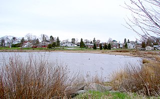
Adolphustown is a geographic area located in Greater Napanee, Ontario, Canada, on the Adolphus Reach of the Bay of Quinte in Lake Ontario. Adolphustown is now part of the town of Greater Napanee. The rural character of the Adolphustown region remains largely undisturbed today and the area, with its picturesque lakefront location, remains popular for the cultivation of apples and strawberries.

The Township of Wellesley is the rural, north-western township of the Regional Municipality of Waterloo in Ontario, Canada. It encompasses 277.79 km2 (107.26 sq mi) and had a population of 11,260 in the Canada 2016 Census.

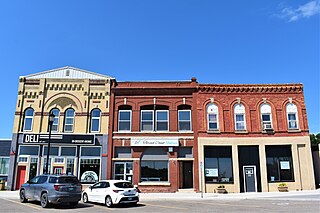
St. Marys is a town in southwestern Ontario, Canada. It is located at the confluence of the north branch of the Thames River and Trout Creek southwest of Stratford, and is surrounded by the Township of Perth South in Perth County, Ontario. St. Marys operates under its own municipal government that is independent from the county's government. Nonetheless, the three entities "enjoy a large degree of collaboration and work together to grow the region as a leading location for industry and people". Census data published for Perth County by Statistics Canada includes St. Marys and most Perth County publications also do, at least in some sections of the document.

Bradford is the primary country urban area of the Town of Bradford West Gwillimbury, Ontario, in Canada. It overlooks a farming community, known as The Holland Marsh, located on the Holland River that flows into Lake Simcoe.
Asphodel–Norwood is a lower tier township municipality in Peterborough County in Central Ontario, Canada, with a 2016 population of 4,109. The land on which the township is situated was the traditional territory of the Mississauga, and became open to European colonization following its survey in 1820. The site that would become Norwood was settled in 1823, and it was incorporated as a village in 1878. The township, in its current form, was created in 1998 by the reunification of the village of Norwood with the surrounding township of Asphodel.

Loyalist is a lower-tier township municipality in central eastern Ontario, Canada on Lake Ontario. It is in Lennox and Addington County and consists of two parts: the mainland and Amherst Island. It was named for the United Empire Loyalists, who settled in the area after the American Revolution.
Blind River is a town situated on the North Channel of Lake Huron in the Algoma District, Ontario, Canada. The town, named after the nearby Blind River, celebrated its centennial in 2006.
Souris is an unincorporated urban community in the Municipality of Souris – Glenwood within the Canadian province of Manitoba that held town status prior to January 1, 2015. It is located within the municipality at the confluence of Plum Creek and Souris River, from which it takes its name. Before 1882, the town was called Plum Creek. The community is home to Canada's longest historic cable-stayed footbridge (177 m [581 ft]), known as the Swinging Bridge, which spans the Souris River that divides the community. The Swinging Bridge was built in 1904 as a means of transportation over the Souris River. Residents of Souris are referred to as Sourisites.

Schomberg is an unincorporated village in northwestern King, Ontario, Canada. It is located north of the Oak Ridges Moraine and south of the Holland River.

The Elliot Lake Vikings were a Canadian junior ice hockey team that originally began playing in the International Junior B Hockey League in 1965. In 1981, the team moved to the Tier II Junior A Northern Ontario Junior Hockey League. The team was located in Elliot Lake, Ontario, Canada.
The Major Intermediate A Hockey League was an ice hockey league in Ontario, Canada, sanctioned by the Ontario Hockey Association. It existed from 1978 to 1983. Its champion was eligible to compete for the W.G. Hardy Trophy, emblematic of Canadian Intermediate A hockey supremacy.

Stone Mills is a lower-tier township north of Greater Napanee in Lennox and Addington County, Ontario, Canada. According to the 2016 census, the township has a population of 7,702.

Ernestown Secondary School or ESS is a Canadian public, comprehensive school located in Odessa, Ontario, Canada. The school services about 450 students from Loyalist Township, Napanee and Stone Mills, Ontario. The town is in the eastern Ontario county of Lennox and Addington approximately 24 kilometers west of the city of Kingston, Ontario. The school offers classes for students in grades nine through twelve and is a member school of the Limestone District School Board. The school motto at ESS is Amor Doctrinae Floreat - "Let the Love of Learning Flourish"
The Quinte Conservation is a conservation authority in the province of Ontario. It is headquartered in Belleville, Ontario. Quinte Conservation was created as a result of the amalgamation of three local conservation authorities in 1996; Moira River, Prince Edward Region and the Napanee Region authorities.

The Bay of Quinte Railway is a former short line railway in eastern Ontario, Canada. It was formed as the Napanee, Tamworth and Quebec Railway (NT&QR), chartered in 1878 by Edward Rathbun and Alexander Campbell, with plans to run from Napanee through Renfrew County and on to the Ottawa Valley. Lacking funding from the governments, development never began.
References
- ↑ Rayburn, Alan (1997). Place names of Ontario. Toronto: University of Toronto Press. p. 336. ISBN 0-8020-7207-0 . Retrieved 23 October 2017.