Longs Peak is a high and prominent mountain in the northern Front Range of the Rocky Mountains of North America. The 14,259-foot (4346 m) fourteener is located in the Rocky Mountain National Park Wilderness, 9.6 miles (15.5 km) southwest by south of the Town of Estes Park, Colorado, United States. Longs Peak is the northernmost fourteener in the Rocky Mountains of Colorado and the highest point in Boulder County and Rocky Mountain National Park. The mountain was named in honor of explorer Stephen Harriman Long and is featured on the Colorado state quarter.

Baintha Brakk or The Ogre is a steep, craggy mountain, 7,285 metres (23,901 ft) high, in the Panmah Muztagh, a subrange of the Karakoram mountain range. It is located in Gilgit-Baltistan, Pakistan. It is famous for being one of the hardest peaks in the world to climb: twenty-four years elapsed between the first ascent in 1977 and the second in 2001.

The Dom is a mountain of the Pennine Alps, located between Randa and Saas-Fee in the canton of Valais in Switzerland. With a height of 4,546 m (14,915 ft), it is the seventh highest summit in the Alps, overall. Based on prominence, it can be regarded as the third highest mountain in the Alps, and the second highest in Switzerland, after Monte Rosa. The Dom is the main summit of the Mischabel group, which is the highest massif lying entirely in Switzerland.

The Barre des Écrins is a mountain in the French Alps with a peak elevation of 4,102 metres (13,458 ft). It is the highest peak of the Massif des Écrins and the Dauphiné Alps and the most southerly alpine peak in Europe that is higher than 4,000 metres. It is the only 4,000-metre mountain in France that lies outside the Mont Blanc Massif. Before the annexation of Savoy in 1860 it was the highest mountain in France.

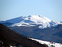
Bieszczady Mountains is a mountain range that runs from the extreme south-east of Poland and north-east of Slovakia through to western Ukraine. It forms the western part of the Eastern Beskids, and is more generally part of the Outer Eastern Carpathians. The mountain range is situated between the Łupków Pass and the Vyshkovskyi Pass. The highest peak of Bieszczady is Mt Pikui in Ukraine. The highest peak of the Polish part is Tarnica.

Bieszczady National Park is the third-largest national park in Poland, located in Subcarpathian Voivodeship in the extreme southeast corner of the country. In 2021, the national park became a UNESCO World Heritage Site.

Midžor or Midzhur is a peak in the Balkan Mountains, situated on the border between Bulgaria and Serbia. At 2,169 metres (7,116 ft), it is the highest peak of the Western Balkan Mountains, as well as the highest in Serbia.

Cisna is the main village of the Gmina Cisna in the Lesko County, in the Subcarpathian Voivodeship (province) of south-eastern Poland. It lies in the Solinka valley in between the Bieszczady mountains.

The Ober Gabelhorn is a mountain in the Pennine Alps in Switzerland, located between Zermatt and Zinal.

Komańcza is a village in the Sanok County, in the Subcarpathian Voivodeship (province) of south-eastern Poland. It is situated in the Bukowsko Upland mountains, located near the towns of Medzilaborce and Palota.

Beinn Challuim is a mountain in the Breadalbane region of the Scottish Highlands. It is east of the village of Tyndrum, in the Forest of Mamlorn, an ancient deer forest at the northern edge of Loch Lomond and the Trossachs National Park. It is a Munro with a height of 1,025 metres (3,363 ft).

The Weisshorn is a major peak of Switzerland and the Alps, culminating at 4,505 metres above sea level. It is part of the Pennine Alps and is located between the valleys of Anniviers and Zermatt in the canton of Valais. In the latter valley, the Weisshorn is one of the many 4000ers surrounding Zermatt, with Monte Rosa and the Matterhorn.

Tokarnia is a peak in the Bukowica Range in southern Poland. Its height is 778 metres (2,552 ft). The southern part is a steep rocky wall, while the other side consists of less steep rocky fields. The Bukowica Range separates the western Low Beskids from the eastern Pogórze Bukowskie.
Bukowica Range part of the Pogórze Bukowskie and Low Beskids in southern Poland. The Bukowica created by the long mountain massif, situated in the eastern part of the Beskid Niski between the valleys of the Wisłok and Osławica rivers. The Bukowica Range separating the west Low Beskids from the east Pogórze Bukowskie.
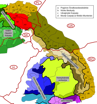
The Low Beskids or Central Beskids are a mountain range in southeastern Poland and northeastern Slovakia. They constitute a middle (central) section of the Beskids, within the Outer Eastern Carpathians.

Binn Chaorach is the second-highest peak in Ireland, at 1,008.2 metres (3,308 ft), on both the Arderin and Vandeleur-Lynam lists. It is part of the MacGillycuddy's Reeks range in County Kerry. Beenkeragh also gives its name the infamous Beenkeragh Ridge, the narrow rocky arete between Beenkeragh and Carrauntoohil, Ireland's highest mountain.
The Fritzerkogel is a mountain in the Tennengebirge in the northern Limestone Alps, Austria. With its elevation of 2,360 metres (7,740 ft), is one of the higher peaks in the mountain range. Seen from the north it stands out as a relatively isolated, broad summit block, whose mighty rock faces and steep, rugged, rocky flanks (Schrofen) fall away on all sides. Its 1,200-metre-high (3,900 ft) south cliff face is impressive and makes it a striking two-thousander.

Breccia Peak is a mountain in the southern Absaroka Range of the Rocky Mountains. It is located in Teton County in the U.S. state of Wyoming, close to the southwest border of the Teton Wilderness within the Bridger-Teton National Forest.

Połonina Caryńska, also known as Połonina Berehowska, is a polonyna in the Bieszczady Mountains laying between valleys of the Dwernik and Wołosaty rivers, which contain the settlements of Brzegi Górne and Ustrzyki Górne. It has four major culminations, the highest is Kruhly Wierch (1297 m), while the other ones have the heights of 1245, 1239 and 1148 metres.

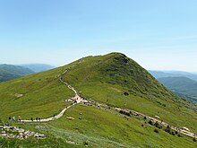
Mała Rawka is a peak in the western Bieszczady Mountains, near Ustrzyki Górne, in southern Poland. Its height is 1,272 metres.