
Nadi is the third-largest conurbation in Fiji. It is located on the western side of the main island of Viti Levu, and had a population of 42,284 at the most recent census, in 2007. A 2012 estimate showed that the population had grown to over 50,000. Nadi is multiracial with many of its inhabitants Asians, Indian or Indigenous Fijians, along with a large transient population of foreign tourists. Along with sugar cane production, tourism is a mainstay of the local economy.

Lautoka is the second largest city in Fiji. It is on the west coast of the island of Viti Levu, in the Ba Province of the Western Division. Lying in the heart of Fiji's sugar cane-growing region, the city has come to be known as the Sugar City. Covering an area of 32 square kilometres, it had a population of 71,573 at the 2017 census, the most recent to date.
Victoria Star 2 is a 96-foot (29 m) passenger only foot ferry owned and operated by San Juan Cruises. The ferry has operated during the summer months between Bellingham, Washington, United States, and the Inner Harbour in Victoria, British Columbia, Canada, making one round trip daily. For the 2011 season, service to Victoria has been cancelled and the ferry is operating to Friday Harbor and other destinations in the San Juan Islands.

Spiekeroog is one of the East Frisian Islands, off the North Sea coast of Germany. It is situated between Langeoog to its west, and Wangerooge to its east. The island belongs to the district of Wittmund, in Lower Saxony in Germany. The only village on the island is also called Spiekeroog. The island is part of the Wadden Sea World Heritage Site by the UNESCO and the Lower Saxon Wadden Sea National Park.

Robinson Crusoe Island is a tourism operation located off the southwest coast of the main island of Viti Levu, Fiji, and has a history dating back 3,500 years. The island is located near Bourewa, an area that is believed is to be the first site for human settlement in Fiji. A pottery site found on the island has been dated back to 1500 BC. Prior to resort development, Likuri Island was reserved as a location for significant ceremonies and Chiefly gatherings. The traditional owner of Likuri Island is the High Chief, Ka Levu Tui Nadroga and the chiefly family.
Pacific Island Air is an Air Charter company operating out of Nadi International Airport, Fiji.
I-177 was an Imperial Japanese Navy Kaidai-type cruiser submarine of the KD7 subclass commissioned in 1942. She served during World War II, patrolling off Australia, taking part in the New Guinea campaign, operating in the North Pacific, and participating in the Palau campaign before she was sunk by the destroyer escort USS Samuel S. Miles (DE-183) in 1944, with no survivors.
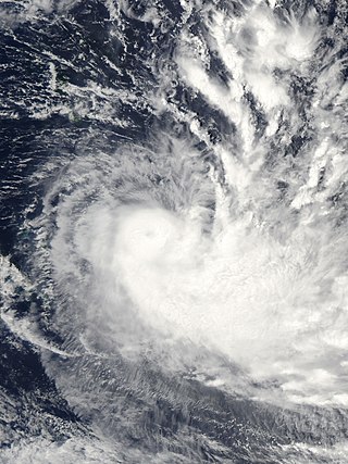
Severe Tropical Cyclone Gene was the deadliest storm as well as the most damaging tropical cyclone of the 2007–08 South Pacific cyclone season east of 160ºE. RSMC Nadi monitored Gene as the 12th tropical disturbance, as well as the fourth tropical cyclone and the third severe tropical cyclone to form west of 160ºE during the 2007–08 South Pacific cyclone season. Gene was also recognised by RSMC Nadi as the fifth tropical cyclone and fourth severe tropical cyclone to form within the South Pacific Ocean during the 2007-08 season.
Castaway Island is an island of the Mamanuca Group in Fiji. It is inhabited, with a tourist resort on its west side. The island has an area of 70 hectares.

Malolo Lailai, also known as Plantation Island, is the second largest and most developed of the Mamanuca Islands, lying 20 kilometres west of Nadi on Fiji's main island Viti Levu. Malolo Lailai is the centre of tourism in the Mamanuca Islands, and consists of four resorts, a number of residential houses, a marina and a golf course. The island can be reached in 50 minutes from Port Denarau by the Malolo Cat, a catamaran, or by Malolo Lailai Airport, a 10-minute flight from Nadi International Airport. Separated by a small isthmus which can be walked at low tide, the larger island of Malolo Levu lies north-west of Malolo Lailai.

Severe Tropical Cyclone Joni was a damaging tropical cyclone that impacted the island nations of Tuvalu and Fiji. It was first noted within the South Pacific Convergence Zone at the start of December 1992, as a shallow tropical depression in the vicinity of the island nation Tuvalu. Over the next few days the system gradually developed further as it affected Tuvalu, before it was declared to be a tropical cyclone and named Joni by the Fiji Meteorological Service (FMS) during December 7. Over the next couple of days the system intensified further as it was steered south-westwards and posed a threat towards the Fijian dependency of Rotuma and the French territory of Wallis and Futuna. The system subsequently peaked as a Category 4 severe tropical cyclone on the Australian tropical cyclone intensity scale as it approached the Fijian Islands during December 10. Over the next couple of days the system moved through the Fijian Islands, before it became an extratropical cyclone during December 13. The system was last noted during the next day as it was absorbed by a mid-latitude trough of low pressure to the east of New Zealand.

Severe Tropical Cyclone Pam was the second most intense tropical cyclone of the South Pacific Ocean in terms of sustained winds and is regarded as one of the worst natural disasters in the history of Vanuatu. A total of 15–16 people lost their lives either directly or indirectly as a result of Pam with many others injured. The storm's impacts were also felt, albeit to a lesser extent, to other islands in the South Pacific, most notably the Solomon Islands, Tuvalu, and New Zealand. Pam is the third most intense storm of the South Pacific Ocean according to pressure, after Winston of 2016 and Zoe of 2002. It is also the second most intense tropical cyclone in 2015, only behind Hurricane Patricia. In addition, Pam is tied with Orson, Monica, Marcus and Fantala for having the second strongest ten-minute maximum sustained winds in the Southern Hemisphere. Thousands of homes, schools and buildings were damaged or destroyed, with an estimated 3,300 people displaced as a result.

Cyclone Ian was a powerful tropical cyclone that formed on January 2, 2014, and dissipated on January 15, 2014. Areas affected by the tropical cyclone include Fiji and Tonga. In Tonga, Ian caused destruction in the Ha'apai islands, as well as one fatality.

Nabuna is a small village on the north western side of Koro Island in the Lomaiviti Group of islands in Fiji. It consists of approximately 60 dwellings with further dwellings in sub-settlements just to the south and east. It is connected to the rest of the island by one road running east and south connecting to the ferry jetty on the southern tip of Koro Island and other villages to the east and south. There is also a small little used track running to the east towards the two resorts on the island.

RFNS Savenaca (401) is a Guardian-class patrol boat, being built in Australia for Fiji's Navy. She will replace RFNS Kula, a Pacific Forum patrol vessel provided by Australia in 1994. She will be the seventh vessel of the class to be completed, and the second of two to be delivered to Fiji. She will be commissioned in March or April of 2020.

Severe Tropical Cyclone Tino was a tropical cyclone which itself and an associated convergence zone caused significant damage across ten island nations in the South Pacific Ocean during January 2020. First noted as a tropical disturbance during January 11, to the southwest of Honiara in the Solomon Islands, the system gradually developed over the next few days as it moved eastwards in between the Solomon Islands and Vanuatu prior to being named Tino as it approached Fiji during January 16. Continuing to track south-eastward, Tino continued strengthening as it passed near Fiji, bringing copious amounts of rainfall to the area. Whilst losing latitude, the system continued to strengthen and peaked as a category 3 tropical cyclone on January 17, with signs of an eye forming. Shortly after peak intensity, Tino was impacted by high wind shear and decreasing sea surface temperatures, triggering a weakening trend. Tino moved out of the tropics shortly thereafter and became an extratropical cyclone during January 19.

Severe Tropical Cyclone Ana was one of three tropical cyclones to impact the island nation of Fiji towards the end of January 2021. The fifth tropical disturbance, third tropical cyclone and second severe tropical cyclone of the 2020–21 South Pacific cyclone season, Ana was first noted as Tropical Disturbance 05F during January 26, while it was located about 220 km (135 mi) to the northeast of Port Vila in Vanuatu. Over the next few days, the system moved eastwards and gradually developed further, before it was declared to be a tropical cyclone and named Ana during January 29. Over the next day, the system moved south-eastwards towards Fiji before it made landfall on the island of Viti Levu. After emerging into the Pacific Ocean, the system intensified into a Category 3 severe tropical cyclone, before it rapidly degenerated into a subtropical low during February 1.

Naval Base Fiji was a naval base built by the United States Navy in 1942 to support the World War II effort. The base was located on Fiji in the Central Pacific Ocean. The base was built as one of many advance bases in the island-hopping campaign towards the Empire of Japan. The US Navy built seaports, seaplane bases and airfields used for staging in the Pacific War.