Naviti (pronounced [naˈβitʃi]) is a volcanic island in the Yasawa Group, in the Western Division of Fiji. Located at 17.13° South and 177.25° East, Naviti covers an area of 34 square kilometres (13sqmi), with a maximum elevation of 388 metres (1,273ft).
The Island is covered in dense tropical dry forests, with an abundance of mangrove trees. The island has been planted greatly with coconut palm trees. Naviti has a humid, tropical climate and remains a target for tropical cyclones, the last one being Cyclone Winston in February 2016.
There are several villages based on Naviti Island, including Soso, Kese, Gunu, Somosomo, Marou, Muaira, Malevu, and Nasoqo. Soso is a chiefly village, which is home to the current chief or "ratu". Each village is interconnected by several trails. Naviti Island is also home to the Yasawa High School, the only high school in the Yasawa Islands, although there are kindergartens and primary schools in most villages. The main economic activity is centred on resort hotels, and several of them are found around the island. Naviti Island is also a popular base for voluntourism.
Madagascar is a large island in the Indian Ocean located 400 kilometres (250 mi) off the eastern coast of Southern Africa, east of Mozambique. It has a total area of 587,040 square kilometres (226,660 sq mi) with 581,540 square kilometres (224,530 sq mi) of land and 6,900 square kilometres (2,700 sq mi) of water. Madagascar is the fourth-largest island in the world. The highest point is Maromokotro, in the Tsaratanana Massif region in the north of the island, at 2,876 metres (9,436 ft).
Hurricane Iniki was a hurricane that struck the island of Kauaʻi on September 11, 1992. It was the most powerful hurricane to strike Hawaiʻi in recorded history, and the only hurricane to directly affect the state during the 1992 Pacific hurricane season. Forming on September 5, 1992, during the strong 1990–1995 El Niño, Iniki was one of eleven Central Pacific tropical cyclones during that season. It attained tropical storm status on September 8 and intensified into a hurricane the next day. After abruptly turning north, Iniki struck Kauaʻi at peak intensity; it had winds of 145 mph and reached Category 4 status on the Saffir–Simpson hurricane scale.
Hurricane Frances was the second most intense tropical cyclone in the Atlantic during 2004 and proved to be very destructive in Florida. It was the sixth named storm, the fourth hurricane, and the third major hurricane of the 2004 Atlantic hurricane season. The system crossed the open Atlantic in late August, moving to the north of the Lesser Antilles while strengthening. Its outer bands struck Puerto Rico and the British Virgin Islands while passing north of the Caribbean Sea. The storm's maximum sustained winds peaked at 145 mph (233 km/h), achieving Category 4 on the Saffir-Simpson Hurricane Scale. As the system's forward motion slowed, the eye passed over San Salvador Island and very close to Cat Island in the Bahamas. Frances was the first hurricane to impact the entire Bahamian archipelago since 1928 and almost completely destroyed their agricultural economy.
The 1928 Atlantic hurricane season was a near average hurricane season in which seven tropical cyclones developed. Of these, six intensified into a tropical storm and four further strengthened into hurricanes. One hurricane deepened into a major hurricane, which is Category 3 or higher on the modern-day Saffir–Simpson scale. The first system, the Fort Pierce hurricane, developed near the Lesser Antilles on August 3. The storm crossed the Bahamas and made landfall in Florida. Two fatalities and approximately $235,000 in damage was reported. A few days after the first storm developed, the Haiti hurricane, formed near the southern Windward Islands on August 7. The storm went on to strike Haiti, Cuba, and Florida. This storm left about $2 million in damage and at least 210 deaths. Impacts from the third system are unknown.
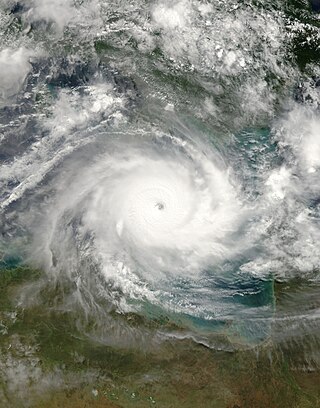
Severe Tropical Cyclone Ingrid was a powerful tropical cyclone which struck northern Australia during the 2004–05 Australian region cyclone season. Its minimum pressure was 924 mbar (hPa).
The Okeechobee hurricane of 1928, also known as the San Felipe Segundo hurricane, was one of the deadliest hurricanes in the recorded history of the North Atlantic basin, and the fourth deadliest hurricane in the United States, only behind the 1900 Galveston hurricane, 1899 San Ciriaco hurricane, and Hurricane Maria. The hurricane killed an estimated 2,500 people in the United States; most of the fatalities occurred in the state of Florida, particularly in Lake Okeechobee. It was the fourth tropical cyclone, third hurricane, the only major hurricane of the 1928 Atlantic hurricane season, and remains the deadliest disaster in Florida’s history to date. It developed off the west coast of Africa on September 6 as a tropical depression, but it strengthened into a tropical storm later that day, shortly before passing south of the Cape Verde islands. Further intensification was slow and halted late on September 7. About 48 hours later, the storm strengthened and became a Category 1 hurricane on the Saffir–Simpson hurricane wind scale. Still moving westward, the system reached Category 4 intensity before striking Guadeloupe on September 12, where it brought great destruction and resulted in 1,200 deaths. The islands of Martinique, Montserrat, and Nevis also reported damage and fatalities, but not nearly as severe as in Guadeloupe.
Hurricane Erin was the first hurricane to strike the contiguous United States since Hurricane Andrew in 1992. The fifth tropical cyclone, fifth named storm, and second hurricane of the unusually active 1995 Atlantic hurricane season, Erin developed from a tropical wave near the southeastern Bahamas on July 31. Moving northwestward, the cyclone intensified into a Category 1 hurricane on the Saffir–Simpson scale near Rum Cay about 24 hours later. After a brief jog to the north-northwest on August 1, Erin began moving to the west-northwest. The cyclone then moved over the northwestern Bahamas, including the Abaco Islands and Grand Bahama. Early on August 2, Erin made landfall near Vero Beach, Florida, with winds of 85 mph (137 km/h). The hurricane weakened while crossing the Florida peninsula and fell to tropical storm intensity before emerging into the Gulf of Mexico later that day.
The 1886 Atlantic hurricane season was an active and record breaking Atlantic hurricane season that ran through the early summer and the first half of fall in 1886. Out of the ten known hurricanes, seven of them struck the United States at that intensity; an all-time record. The season also had the most active June, and reached the modern seasonal average of hurricanes by mid-August. This occurred once more in 1893, and has remained a distant record since. Four of the hurricanes also reached major hurricane status. However, with the absence of modern satellites and other remote-sensing technologies, only storms that affected populated land areas or encountered ships at sea were documented. The actual total is likely higher with an average under-count bias estimate of zero to six tropical cyclones per year between 1851 and 1885 and zero to four per year between 1886 and 1910. Several studies have also suggested that the 1883 eruption of Krakatoa may have played a significant role in the unusual and enhanced activity. Hurricane Seven and Tropical Storm Eleven were recently documented in 1996 by Jose Fernandez-Partagas and Henry Diaz, in which they also proposed alterations to other known tracks of several other 1886 storms.
Ba is a province of Fiji, occupying the north-western sector of Viti Levu, Fiji's largest island. It is one of fourteen provinces in the nation of Fiji, and one of eight based in Viti Levu. It is Fiji's most populous province, with a population of 247,708 – more than a quarter of the nation's total – at the 2017 census. It covers a land area of 2,634 km2 (1,017 sq mi), the largest of any province.
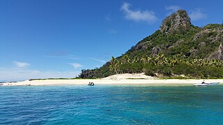
Monuriki is a small, uninhabited island situated off the coast of Viti Levu in the Fiji Islands, in Melanesia in the South Pacific Ocean. Monuriki is part of the Atolls islands, and related to a group of three islets in the larger group of islands known as the Mamanuca Islands. This coral and volcanic island is the smallest islet and the southernmost of a small group of three islets, west of Tavua.
Severe Tropical Cyclone Gene was the deadliest storm as well as the most damaging tropical cyclone of the 2007–08 South Pacific cyclone season east of 160ºE. RSMC Nadi monitored Gene as the 12th tropical disturbance, as well as the fourth tropical cyclone and the third severe tropical cyclone to form west of 160ºE during the 2007–08 South Pacific cyclone season. Gene was also recognised by RSMC Nadi as the fifth tropical cyclone and fourth severe tropical cyclone to form within the South Pacific Ocean during the 2007-08 season.
The 1949 Florida hurricane, also known as the Delray Beach hurricane, was a damaging and powerful tropical cyclone that caused significant damage in the southern portions of the state late in the month of August. The second recorded tropical cyclone of the annual hurricane season, the system originated from a tropical wave near the northern Leeward Islands on August 23. Already a tropical storm upon initial observations, the cyclone curved west-northwestward and intensified, becoming a hurricane on August 25. Rapid intensification ensued as the storm approached the central Bahamas early on August 26, with the storm reaching Category 4 hurricane strength later that day and peaking with maximum sustained winds of 130 mph (210 km/h) shortly after striking Andros. Late on August 26, the storm made landfall near Lake Worth, Florida, at the same intensity. The cyclone initially weakened quickly after moving inland, falling to Category 1 status early the next day. Shortly thereafter, the system curved northward over the Nature Coast and entered Georgia on August 28, where it weakened to a tropical storm. The storm then accelerated northeastward and became extratropical over New England by August 29. The remnants traversed Atlantic Canada and much of the Atlantic Ocean before dissipating near Ireland on September 1.
The 1933 Treasure Coast hurricane was the second-most intense tropical cyclone to strike the United States during the active 1933 Atlantic hurricane season. The eleventh tropical storm, fifth hurricane, and the third major hurricane of the season, it formed east-northeast of the Leeward Islands on August 31. The tropical storm moved rapidly west-northwestward, steadily intensifying to a hurricane. It acquired peak winds of 140 mph (220 km/h) and passed over portions of the Bahamas on September 3, including Eleuthera and Harbour Island, causing severe damage to crops, buildings, and infrastructure. Winds over 100 mph (160 km/h) affected many islands in its path, especially those that encountered its center, and many wharves were ruined.
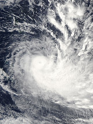
Severe Tropical Cyclone Monica was the most intense tropical cyclone, in terms of maximum sustained winds, on record to impact Australia. The 17th and final storm of the 2005–06 Australian region cyclone season, Monica originated from an area of low pressure off the coast of Papua New Guinea on 16 April 2006. The storm quickly developed into a Category 1 cyclone the next day, at which time it was given the name Monica. Travelling towards the west, the storm intensified into a severe tropical cyclone before making landfall in Far North Queensland, near Lockhart River, on 19 April 2006. After moving over land, convection associated with the storm quickly became disorganised.
The 1970–71 South Pacific cyclone season, in terms of severe tropical cyclones, was the least active season on record, with none of its six storms strengthening above Category 2 tropical cyclone intensity. It was a below average season, beginning late and ending early. The season officially began on November 15 and ended on April 30, but the first storm formed a month after that, on December 15.
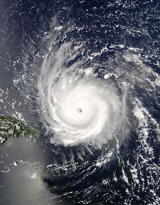
Severe Tropical Cyclone Joni was a damaging tropical cyclone that impacted the island nations of Tuvalu and Fiji. It was first noted within the South Pacific Convergence Zone at the start of December 1992, as a shallow tropical depression in the vicinity of the island nation Tuvalu. Over the next few days the system gradually developed further as it affected Tuvalu, before it was declared to be a tropical cyclone and named Joni by the Fiji Meteorological Service (FMS) during December 7. Over the next couple of days the system intensified further as it was steered south-westwards and posed a threat towards the Fijian dependency of Rotuma and the French territory of Wallis and Futuna. The system subsequently peaked as a Category 4 severe tropical cyclone on the Australian tropical cyclone intensity scale as it approached the Fijian Islands during December 10. Over the next couple of days the system moved through the Fijian Islands, before it became an extratropical cyclone during December 13. The system was last noted during the next day as it was absorbed by a mid-latitude trough of low pressure to the east of New Zealand.
Severe Tropical Cyclone Sina was the only named tropical cyclone to develop within the South Pacific basin during the 1990–91 season. The system was first noted as a shallow depression within the South Pacific Convergence Zone to the west of Wallis Island. Over the next three days the system moved towards the west-northwest, before it was named Sina during November 24, after it had developed into a tropical cyclone. Over the next couple of days the system intensified further and developed an eye feature as it erratically moved towards Fiji. Sina subsequently peaked in intensity during November 26, before the system passed through the Fijian Islands over the next two days as it started to gradually weaken. Sina subsequently passed just to the north of Tongatapu in Tonga during November 29, before it passed about 160 km (100 mi) to the south of Niue and near the Southern Cook Islands during the next day. The system subsequently rapidly weakened and became an extratropical cyclone during December 1, before they were absorbed by an advancing trough of low pressure near 50°S on December 4.
Viwa Island, Yasawa is located approximately 70 km northwest of Denarau situated in the Yasawa Islands of Fiji.
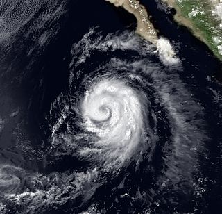
Hurricane Ismael was responsible for significant flooding throughout the Inland Empire of the United States in August 1983. The cyclone was the tenth depression, ninth named storm, and fifth hurricane of the 1983 Pacific hurricane season. The origins of Hurricane Ismael were from a northward bulge of the Intertropical Convergence Zone (ITCZ) in early August, which resulted in the formation of a tropical depression on August 8. Six hours later, it was upgraded into Tropical storm Ismael. Continuing to intensify, Ismael was upgraded into a hurricane late on August 10 and subsequently developed an eye. After bypassing the Revillagigedo Islands, the storm reached its peak wind speed of 100 mph (160 km/h). Late on August 11, Hurricane Ismael began to weaken as it encountered cooler waters. The following day, Ismael was downgraded into a tropical storm. On August 14, the storm was downgraded into a tropical depression approximately 250 mi (400 km) west of Point Ensenada. After turning north, Ismael dissipated later that day near Guadalupe Island.
Severe Tropical Cyclone Yasa was the second Category 5 severe tropical cyclone in 2020 after Harold in the 2019–20 South Pacific cyclone season. Yasa was the second tropical disturbance, as well as the first tropical cyclone and severe tropical cyclone of the 2020–21 South Pacific cyclone season. Yasa was first noted as an area of low pressure to the north of Port Vila in Vanuatu during December 10. Over the next few days, the system gradually developed further as it absorbed Tropical Depression 01F, before it was classified as a tropical cyclone and named Yasa by the Fiji Meteorological Service on December 13.
This page is based on this Wikipedia article Text is available under the CC BY-SA 4.0 license; additional terms may apply. Images, videos and audio are available under their respective licenses.

 Palm trees.
 Corals at the west coast.
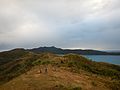 View from the ridge path in southern Naviti.
 Beach on the west coast.
 Stingray.