Gunnison is a home rule municipality that is the county seat and the most populous municipality of Gunnison County, Colorado. The city population was 6,560 at the 2020 United States Census. Gunnison was named in honor of John W. Gunnison, a United States Army officer who surveyed for a transcontinental railroad in 1853.

Black Canyon of the Gunnison National Park is an American national park located in western Colorado and managed by the National Park Service. There are two primary entrances to the park: the south rim entrance is located 15 miles (24 km) east of Montrose, while the north rim entrance is 11 miles (18 km) south of Crawford and is closed in the winter. The park contains 12 miles (19 km) of the 48-mile (77 km) long Black Canyon of the Gunnison River. The national park itself contains the deepest and most dramatic section of the canyon, but the canyon continues upstream into Curecanti National Recreation Area and downstream into Gunnison Gorge National Conservation Area. The canyon's name owes itself to the fact that parts of the gorge only receive 33 minutes of sunlight a day, according to Images of America: The Black Canyon of the Gunnison. In the book, author Duane Vandenbusche states, "Several canyons of the American West are longer and some are deeper, but none combines the depth, sheerness, narrowness, darkness, and dread of the Black Canyon."

The Deschutes River in central Oregon is a major tributary of the Columbia River. The river provides much of the drainage on the eastern side of the Cascade Range in Oregon, gathering many of the tributaries that descend from the drier, eastern flank of the mountains. The Deschutes provided an important route to and from the Columbia for Native Americans for thousands of years, and then in the 19th century for pioneers on the Oregon Trail. The river flows mostly through rugged and arid country, and its valley provides a cultural heart for central Oregon. Today the river supplies water for irrigation and is popular in the summer for whitewater rafting and fishing.

The North Platte River is a major tributary of the Platte River and is approximately 716 miles (1,152 km) long, counting its many curves. In a straight line, it travels about 550 miles (890 km), along its course through the U.S. states of Colorado, Wyoming, and Nebraska.

The Gunnison River is located in western Colorado, United States and is one of the largest tributaries of the Colorado River.
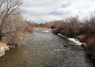
The Uncompahgre River is a tributary of the Gunnison River, approximately 75 mi (121 km) long, in southwestern Colorado in the United States. Lake Como at 12,215 ft (3723m) in northern San Juan County, in the Uncompahgre National Forest in the northwestern San Juan Mountains is the headwaters of the river. It flows northwest past Ouray, Ridgway, Montrose, and Olathe and joins the Gunnison at Confluence Park in Delta.

The Stillwater River is a tributary of the Yellowstone River. Approximately 70 miles (113 km) long, it runs through southern Montana in the United States. The Stillwater River has also been known as: the Itchkeppearja River, Rose River, Rosebud River and Stillwater Creek.

Lees Ferry is a site on the Colorado River in Coconino County, Arizona in the United States, about 7.5 miles (12.1 km) southwest of Page and 9 miles (14 km) south of the Utah–Arizona state line.

The John Day River is a tributary of the Columbia River, approximately 284 miles (457 km) long, in northeastern Oregon in the United States. It is known as the Mah-Hah River by the Cayuse people, the original inhabitants of the region. Undammed along its entire length, the river is the fourth longest free-flowing river in the contiguous United States. There is extensive use of its waters for irrigation. Its course furnishes habitat for diverse species, including wild steelhead and Chinook salmon runs. However, the steelhead populations are under federal Endangered Species Act (ESA) protections, and the Chinook salmon have been proposed for such protection.

Animas River is a 126-mile-long (203 km) river in the western United States, a tributary of the San Juan River, part of the Colorado River System.

The Jarbidge River is a 51.8-mile-long (83.4 km), high elevation river in Elko County, Nevada and Owyhee County, Idaho in the United States. The Jarbidge originates as two main forks in the Jarbidge Mountains of northeastern Nevada and then flows through basalt and rhyolite canyons on the high plateau of the Owyhee Desert before joining the Bruneau River.

The White Salmon River is a 44-mile (71 km) tributary of the Columbia River in the U.S. state of Washington. Originating on the slopes of Mount Adams, it flows into the Columbia Gorge near the community of Underwood. Parts of the river have been designated Wild and Scenic. The principal tributaries of the White Salmon River include Trout Lake and Buck, Mill, Dry, Gilmer, and Rattlesnake Creeks.

Angling in Yellowstone National Park is a major reason many visitors come to the park each year and since it was created in 1872, the park has drawn anglers from around the world to fish its waters. In 2006, over 50,000 park fishing permits were issued to visitors. The park contains hundreds of miles of accessible, high-quality trout rivers containing wild trout populations—over 200 creeks, streams and rivers are fishable. There are 45 fishable lakes and several large lakes are easily accessible to visitors. Additionally, the park's remote sections provide anglers ample opportunity to visit rivers, streams, creeks and lakes that receive little angling pressure. With the exception of one specially designated drainage, all the park's waters are restricted to artificial lures and fly fishing. The Madison, Firehole and a section of the Gibbon rivers are restricted to fly fishing only.

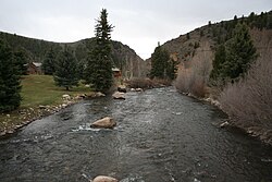
East River is a 38.3-mile-long (61.6 km) stream in Gunnison County, Colorado, United States. It flows south from Emerald Lake in the Maroon Bells Wilderness to a confluence with the Taylor River that forms the Gunnison River.

Tomichi Creek is a 71.8-mile-long (115.6 km) tributary of the Gunnison River in Gunnison County, Colorado, United States.

Quartz Creek is a stream in Gunnison County, Colorado, United States, that is a tributary of Tomichi Creek.

Part of the Uncompahgre Project located on the western slope of central Colorado, the Taylor Park Dam was engineered by the Bureau of Reclamation. It is located on the Taylor River, a tributary of the Gunnison River, and the dam is used to create the Taylor Park Reservoir in Gunnison County, Colorado.

Tapeats Creek is a creek located entirely within the Grand Canyon National Park. It flows southwest from its source near the North Rim of the canyon to the Colorado River at the base of the canyon. It was named by the Second Powell Expedition in the winter of 1871–1872 for a Southern Paiute Indian who claimed ownership of the stream. It contributes the largest amount of water to the Colorado of any tributary on the north side within the Grand Canyon.

Blue Creek is a tributary of the Gunnison River in Gunnison County, Colorado. It forms at the confluence of Little Blue Creek and Big Blue Creek adjacent to the intersection of U.S. Highway 50 and Alpine Plateau Road in Blue Creek Canyon.