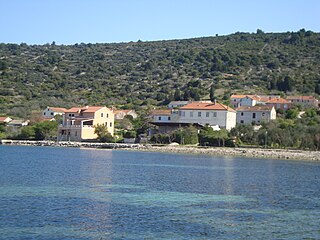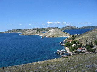

Telašćica (pronounced [telaʃt͡ʃit͡sa] ) is a bay in the southeastern part of the island of Dugi Otok, Croatia, in the Adriatic Sea. It is a designated nature park, full of wildlife and marine creatures.


Telašćica (pronounced [telaʃt͡ʃit͡sa] ) is a bay in the southeastern part of the island of Dugi Otok, Croatia, in the Adriatic Sea. It is a designated nature park, full of wildlife and marine creatures.

Telašćica is a 10 km long, 160–1800 m wide, deep inlet dotted with cliffs, islets and bays. The cliffs of Dugi Otok, called the stene locally, rise to 161 m above sea level and drop down to a depth of 90 m. [1] Telašćica bay, which actually consists of three smaller bays, is a good, safe harbour for all kinds of vessels. The northeastern side of the bay is completely bare, but the southwestern shore is covered in thick forest of pine, olive and fig trees. [2] There are six islets and rocks in the bay: Korotan, Galijola, Gozdenjak, Farfarikulac, Gornji Školj and Donji Školj. Lake Mir is a saltwater lake on a narrow strip of land between Telašćica bay and the open sea. The lake is salty due to underground connections to the sea. [3]

The Kornati archipelago of Croatia, also known as the Stomorski islands, is located in the northern part of Dalmatia, south from Zadar and west from Šibenik, in the Šibenik-Knin County. With 35 kilometres length and 89 islands, some large, some small, in a sea area of about 320 square kilometres (124 sq mi), the Kornati are the densest archipelago in the Mediterranean Sea. From northwest to southeast, and from northeast to southwest they stretch for 13 km. The name of the archipelago is the plural form of the name of the largest island, called Kornat.

Zadar County is a county in Croatia, it encompasses northern Dalmatia and southeastern Lika. Its seat is the city of Zadar.

The Učka is a mountain range in western Croatia. It rises behind the Opatija riviera, on the eastern side of the Istrian peninsula.

Soline is a small Croatian village on the island of Dugi Otok. It is divided in two parts: Bura and Japar, located on Solišćica Luka Bay. The village was named after the old salt pans in the bay.

Dugi Otok is part of Croatia and the seventh largest island in the Adriatic Sea. It is located off the Dalmatian coast, west of Zadar. It is the largest and westernmost of the Zadarian Islands, and derives its name from its distinctive shape: it is 44.5 km long by 4.8 km wide, with an area of 114 square kilometres (44 sq mi). Its elevation reaches 300 m; and many of its higher portions contain stands of Maritime Pine.

Iž is an island in the Zadar Archipelago within the Croatian reaches of the Adriatic Sea. Its settlements are located exclusively on island's eastern part, facing Ugljan. The main settlement, Veli Iž, is situated in the bay on the north-western shore, while Mali Iž is situated on the south-eastern shore and consists of three hamlets — Muće, Makovac and Porovac — located on three hills, below which are two bays — the bay of Knež below Porovac and the bay of Komoševa below Makovac.

Rava is an island in the Croatian part of the Adriatic Sea. It is situated in the Zadar Archipelago, between Iž and Dugi Otok, 16 nautical miles (30 km) from Zadar. Its area is 3.6 km2, and it has a population of 117. The only settlements on the island are Vela Rava and Mala Rava. The coast of the island is very indented with 13 bays and 15.45 kilometres of coastline. The island is composed of dolomite. The primary industries are agriculture and fishing.

Sestrunj is an island in the Croatian part of the Adriatic Sea. It is situated in Zadar Archipelago, between Ugljan, Rivanj and Dugi Otok. Its area is 15.1 square kilometres, and it has population of 48. The only settlement is also called Sestrunj and is located in the island's interior. The island is partially covered with maquis shrubland and low forests. Remains of an Illyrian fort are situated on the island. The island's main industries are agriculture and fishing.
Brusnik is an uninhabited volcanic island in the Croatian part of the Adriatic Sea. The island is part of the Dalmatian archipelago.

The Adriatic Sea is a body of water separating the Italian Peninsula from the Balkan Peninsula. The Adriatic is the northernmost arm of the Mediterranean Sea, extending from the Strait of Otranto to the northwest and the Po Valley. The countries with coasts on the Adriatic are Albania, Bosnia and Herzegovina, Croatia, Italy, Montenegro, and Slovenia.

Kornat is an island in the Croatian part of the Adriatic Sea, in central Dalmatia. With an area of 32.44 km2 it is the 16th largest island in Croatia and the largest island in the eponymous Kornati islands archipelago. It is part of the Kornati National Park, which is composed of a total of 89 islands, islets and rocks.

Žut is an uninhabited island in the Croatian part of the Adriatic Sea, in central Dalmatia. With an area of 14.83 km2 (5.73 sq mi) it is the 28th largest island in Croatia and the second largest island in the Kornati archipelago, after Kornat. Although most of the archipelago, composed of 89 islands, islets and rocks, is included in the Kornati National Park, the island of Žut is not.

Prvić is an uninhabited island in the Croatian part of the Adriatic Sea, located in the Kvarner Gulf. It is the largest of the so-called Senj Islands, a group of small islands and islets located off the coast of the mainland city of Senj, lying between the larger islands of Krk and Rab. Other significant islands in the Senj group are Sveti Grgur and Goli Otok, along with a number of islets and rocks, which are all uninhabited. Prvić has an area is 12.76 square kilometres (4.93 sq mi), which makes it the largest uninhabited Croatian island and 30th largest overall.

Plavnik is an unpopulated island in the Adriatic Sea, belonging to Croatia located between the Central Straits and the Kvarner Bay. The Krusija Channel cuts it off from the eastern coast of the island of Cres. This channel is the shortest route from the Adriatic Sea through the islands to Rijeka. A lighthouse, established in 1890, sits at the northwestern point of the islet, marking the east side of the narrowest opening of the Krusija Channel.
Lavdara is an uninhabited Croatian island in the Adriatic Sea located east of Dugi Otok. Its area is 2.27 km2 (0.88 sq mi).

Katina is a Croatian island in the Adriatic Sea located between Dugi Otok to the north and Kornat to the south. Its area is 1.17 km2 (0.45 sq mi).

The Zadar Archipelago is a group of islands in the Adriatic Sea, near the Croatian city of Zadar.
43°54′00″N15°09′36″E / 43.90000°N 15.16000°E