
The Vitim is a major tributary of the Lena. Its source is east of Lake Baikal, at the confluence of rivers Vitimkan from the west and China from the east. The Vitim flows first south, bends eastwards and then northward in the Vitim Plateau. Then it flows north through the Stanovoy Highlands and the town of Bodaybo. Including river Vitimkan, its western source, it is 1,978 kilometres (1,229 mi) long, and has a drainage basin of 225,000 square kilometres (87,000 sq mi).

Baunt is the name of a body of fresh water in the Bauntovsky District, Buryatia, Russia.

The Muya is a left tributary of the Vitim in Buryatia, Russia. It is 365 kilometres (227 mi) long and has a drainage basin of 11,900 square kilometres (4,600 sq mi).

Bauntovsky District is an administrative and municipal district (raion), one of the twenty-one in the Republic of Buryatia, Russia. It is located in the northeast of the republic. The area of the district is 66,816 square kilometers (25,798 sq mi). Its administrative center is the rural locality of Bagdarin. As of the 2010 Census, the total population of the district was 9,667, with the population of Bagdarin accounting for 49.0% of that number.

Busani is the name of a body of fresh water in the Bauntovsky District, Buryatia, Russia. The name originated in the Evenki language, meaning "where people drown".

Vitim Plateau is a plateau in Buryatia and Zabaykalsky Krai, Russia. The plateau is sparsely populated, the main settlements are Romanovka and Bagdarin. An area of the plateau is an ancient volcanic field with a number of cinder cones and volcanoes, the last of which was active about 810,000 years before present.

Telemba is a rural locality and the administrative centre of Kondisnkoye Rural Settlement, Yeravninsky District, Republic of Buryatia, Russia. The population was 1,256 as of 2017. There are 16 streets.
Tselinny is a rural locality and the administrative centre of Tselinnoye Rural Settlement, Yeravninsky District, Republic of Buryatia, Russia. The population was 417 as of 2017. There are 11 streets.

The Karenga is a river in Zabaykalsky Krai, southern East Siberia, Russia. It is 366 kilometres (227 mi) long, and has a drainage basin of 10,100 square kilometres (3,900 sq mi). The area through which the river flows is inhabited by indigenous Tungus people.
The Konda is a river in Buryatia, southern East Siberia, Russia. It is 285 kilometres (177 mi) long, and has a drainage basin of 10,400 square kilometres (4,000 sq mi). There are a few inhabited places close to the banks of the river, including Tselinny, Konda, Telemba and Alekseevka in the Yeravninsky District.

Bolshoy Yeravna is a fresh water body in the Yeravninsky District, Buryatia, Russia.
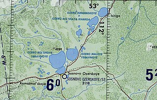
Isinga is a fresh water body in the Yeravninsky District, Buryatia, Russia.

Ikat Range is a mountain range in Buryatia, Russia. It runs in a parallel direction to the Baikal Rift. The range is named after two small rivers sharing the name "Ikat" which have their sources in opposite slopes of the range one is a tributary of the Gargi and the other a tributary of the Vitimkan.

Kapylyushi or Kapylyushy is a body of fresh water in the Bauntovsky District, Buryatia, Russia. The name originated in an Evenki word.

The Tsipikan is a river in Buryatia, Russia. It is the second largest tributary of the Tsipa, after the Amalat, of the Vitim basin. The river is 329 kilometres (204 mi) long, and has a drainage basin of 6,710 square kilometres (2,590 sq mi). There is gold mining in the banks of the river.

Dorong is a body of fresh water in the Bauntovsky District, Buryatia, Russia. The name originated in an Evenki word.
Yeravna-Khorga Lake System is a group of relatively shallow fresh water bodies in the Yeravninsky District, Buryatia, Russia. The villages of Isinga, Khorga, Tuldun, Gunda, Shiringa, Garam, as well as Sosnovo-Ozerskoye, the district capital, are located near the lakes.

The Bolshoy Khapton is a mountain range in Bauntovsky District, Buryatia, Russia.
The Delyun-Uran Range is a mountain range in Irkutsk Oblast and Buryatia, Russia, part of the Stanovoy Highlands.

