Vitim Plateau

Last updated
Vitim Plateau
Вити́мское плоского́рье / Витимэй хадалиг газар
Reka Vitim029.png
The Vitim in its upper course flowing across the plateau
Highest point
Elevation 1,846 m (6,056 ft)
Dimensions
Length450 km (280 mi)
Width250 km (160 mi)
Area10,000 km2 (3,900 sq mi)
Geography
Relief Map of Buryatia.svg
Red triangle with thick white border.svg
Location in Buryatia, Russia
CountryRussia
Federal subject Buryatia
Region Transbaikalia
Range coordinates 54°00′N113°30′E / 54.000°N 113.500°E / 54.000; 113.500
Parent range South Siberian System
Climbing
Easiest route From Bagdarin Airport
Parts of the Vitim Plateau have been traditionally inhabited by Evenks. Bauntovsky District. Turizm097.jpg
Parts of the Vitim Plateau have been traditionally inhabited by Evenks. Bauntovsky District.

Vitim Plateau is a plateau in Buryatia and Zabaykalsky Krai, Russia. The plateau is sparsely populated, the main settlements are Romanovka and Bagdarin. An area of the plateau is an ancient volcanic field with a number of cinder cones and volcanoes, the last of which was active about 810,000 years before present.

Contents

The P436 regional road connecting Ulan-Ude and Chita passes through Romanovka across the plateau.

Geography

The Vitim Plateau lies along the headwaters of the Vitim River, a tributary of the Lena [1] between the Southern Muya Range to the north, the Ikat Range to the west, the Yablonoi Mountains to the south, [2] and in the east with the lower reaches of the Kalakan River to the right bank of the lower reaches of the Karenga River (both Vitim tributaries) and the latter's right tributary, the Bugarikta. [3]

The Vitim River begins at the confluence of the China and Vitimkan rivers on the plateau and makes a wide bend around the volcanic zone before flowing northwards. Rivers Tsipa, Tsipikan and Amalat cut across the plateau and the Baunt Depression is located in the northwestern corner. [2]

The plateau has a surface area of 10,000 square kilometres (3,900 sq mi). [4] In it smooth, low mountain ranges such as the Bolshoy Khapton, with average heights between 1,200 metres (3,900 ft) and 1,600 metres (5,200 ft), alternate with intermontane basins. The Vitim Plateau is covered by larch taiga and forest steppe, as well as thickets of shrubby birches, meadows, and swampy areas in the river basins. [5] The volcanic field in its southwestern part has an area of 4,500 square kilometres (1,700 sq mi). [6] [7] There are a number of lakes, such as Baunt, Busani, Kapylyushi, Telemba, Arakhley, Bolshoy and Maly Yeravna. [2] The area is marked by permafrost.

Volcanism

About five circular groups of volcanoes occur in the field, which is in turn subdivided into two major provinces. [1] Both central volcanoes and cinder cones occur in the volcanic field, with the largest volcanoes reaching heights of 150 metres (490 ft) and diameters of 1.5 kilometres (0.93 mi). [8]

Geology

Since the Oligocene and especially the Pliocene, the Asian Plate has been rifting apart in the Baikal Rift where the Siberian craton and a Paleozoic assembly of terranes (ancient microcontinents) form a contact zone. This rifting process is associated with volcanism in the neighbourhood of the rift zone, and this volcanism has produced about 5,000 cubic kilometres (1,200 cu mi) of volcanic rock in several volcanic fields, [9] including the Udokan Plateau and the Vitim Plateau which are the largest volcanic fields of the Baikal Rift. [10]

The reasons for the rifting process aren't well known. One theory holds that the collision between India and Asia and other tectonic processes triggered the pull-apart in the Baikal Rift. Another one postulates the existence of thermal anomalies such as a mantle plume beneath the Baikal Rift as the driving force of the rifting. [9]

The basement beneath the Baikal Rift is granitic and up to 20 kilometres (12 mi) thick. It may be of Paleozoic age. Other rocks in the region are sediments close to river valleys and Mesozoic volcanic rocks. [9]

Composition

Vitim Plateau volcanic rocks are mainly alkaline to subalkaline basalts, nephelinites and melanephelinites, with phenocryst phases containing clinopyroxene, olivine and plagioclase. Younger rocks have a tendency towards alkaline compositions. [9]

The melts that give rise to Vitim Plateau magmas appear to originate in the lithospheric mantle, starting from garnet pyroxenite and peridotite and leaving phlogopite as residual phase when starting from pyroxenite. [9] Petrology indicates that a complex magma production process takes place beneath the Vitim Plateau, including remelting and crystallization. [11]

Eruption history

Two volcanic phases have been identified in the Vitim Plateau. The first took place during the Miocene; [4] potassium-argon dating has yielded ages of 10.65 - 6.6 million years ago. [9]

The second occurred during the Pleistocene with the most recent eruption dated 810,000 years ago. [4] Later volcanic activity was concentrated in river valleys and cones on the surface of the plateau. [12]

Related Research Articles

<span class="mw-page-title-main">Peridotite</span> Coarse-grained ultramafic igneous rock type

Peridotite ( PERR-ih-doh-tyte, pə-RID-ə-) is a dense, coarse-grained igneous rock consisting mostly of the silicate minerals olivine and pyroxene. Peridotite is ultramafic, as the rock contains less than 45% silica. It is high in magnesium (Mg2+), reflecting the high proportions of magnesium-rich olivine, with appreciable iron. Peridotite is derived from Earth's mantle, either as solid blocks and fragments, or as crystals accumulated from magmas that formed in the mantle. The compositions of peridotites from these layered igneous complexes vary widely, reflecting the relative proportions of pyroxenes, chromite, plagioclase, and amphibole.

<span class="mw-page-title-main">Northern Cordilleran Volcanic Province</span> Geologic province in the Pacific Northwest of North America

The Northern Cordilleran Volcanic Province (NCVP), formerly known as the Stikine Volcanic Belt, is a geologic province defined by the occurrence of Miocene to Holocene volcanoes in the Pacific Northwest of North America. This belt of volcanoes extends roughly north-northwest from northwestern British Columbia and the Alaska Panhandle through Yukon to the Southeast Fairbanks Census Area of far eastern Alaska, in a corridor hundreds of kilometres wide. It is the most recently defined volcanic province in the Western Cordillera. It has formed due to extensional cracking of the North American continent—similar to other on-land extensional volcanic zones, including the Basin and Range Province and the East African Rift. Although taking its name from the Western Cordillera, this term is a geologic grouping rather than a geographic one. The southmost part of the NCVP has more, and larger, volcanoes than does the rest of the NCVP; further north it is less clearly delineated, describing a large arch that sways westward through central Yukon.

<span class="mw-page-title-main">Potrillo volcanic field</span> Volcanic field in United States and Mexico

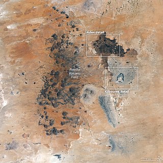
The Potrillo volcanic field is a monogenetic volcanic field located on the Rio Grande Rift in southern New Mexico, United States and northern Chihuahua, Mexico. The volcanic field lies 22 miles (35 km) southwest of Las Cruces, and occupies about 4,600 square kilometers (1,800 sq mi) near the U.S. border with Mexico.

<span class="mw-page-title-main">Baikal Rift Zone</span> Part of the boundary between the Amur and Eurasian tectonic plates.

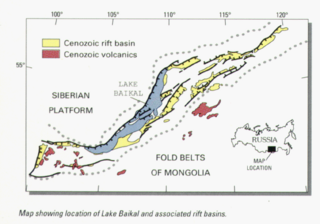
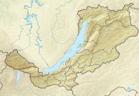
The Baikal Rift Zone is a series of continental rifts centered beneath Lake Baikal in southeastern Russia. Current strain in the rifts tends to be extending with some shear movement. A series of basins form along the zone for more than 2,000 kilometres (1,200 mi), creating a rift valley. The rifts form between the Eurasian Plate to the west and the Amur Plate to the east.

<span class="mw-page-title-main">San Quintín Volcanic Field</span> Volcanic field in Baja California, Mexico

The San Quintín Volcanic Field is a collection of ten or eleven volcanic cinder cones situated along the Pacific coast of the Baja California peninsula in Mexico. The field formed by repeated eruptions beginning in the Pleistocene and ending about 3000 years ago. It is one of several known Quaternary period volcanic fields in Baja. The lava shields appear to have first grown as subaqueous volcanoes that emerged as islands.

The Igwisi Hills are a volcanic field in Kaliua District of Tabora Region of Tanzania. Three tuff cones are found there, one of which is associated with a lava flow. They are one of the few locations of possibly kimberlitic lava flows on Earth.

<span class="mw-page-title-main">Udokan Plateau</span> Volcanic field in Russia

The Udokan Plateau is a volcanic field in Transbaikalia, Russia. It covers a surface area of 3,000 square kilometres (1,200 sq mi) northeast of Lake Baikal in North Asia. Volcanism in the Udokan Plateau included both basaltic lava flows and later individual volcanic cones. Volcanism commenced in the Miocene and continued on into the Holocene.

<span class="mw-page-title-main">Jom-Bolok volcanic field</span> Volcanic field in Russia

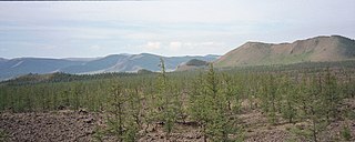
Jom-Bolok, also known as Volcano Valley and East Sayan Volcanic Field, is a volcanic field in Russia, 200 kilometres (120 mi) west of Lake Baikal. It is part of the Baikal rift zone which is also responsible for volcanism elsewhere around Lake Baikal. The volcanic activity has generated long lava flows and cinder cones. One of the lava flows is 70 kilometres (43 mi) long and has a volume of 7.9 cubic kilometres (1.9 cu mi).

<span class="mw-page-title-main">Khanuy-Gol</span> Volcanic field in Mongolia

Khanuy-Gol is a volcanic field in Mongolia. Khanuy-Gol is located in the northern Hangai range, north of the settlement of Bulgan.

<span class="mw-page-title-main">Taryatu-Chulutu</span> Volcanic Field in Mongolia

Taryatu-Chulutu is a volcanic field in Mongolia. It is part of a volcanic area in Central Asia in the Hangai range that may be linked to the rifting of the Lake Baikal Rift. The field itself is located within the valleys of the Chuluut and Suman rivers. Volcanic activity occurred in the Miocene, Pliocene, Pleistocene and Holocene. The Khorgo cinder cone erupted during the Holocene and lava flows from it formed a lava dam generating Terkhiin Tsagaan Nuur lake.

Joanne S. Johnson is a geologist and Antarctic scientist, who has worked for British Antarctic Survey (BAS) since 2002. She works in the palaeoenvironments, ice sheets and climate change team and is best known for her work on glacial retreat. The Johnson Mesa in James Ross Island, Antarctica is named in her honour.

Azas Plateau is a volcanic field in Russia. It is also known as East Tuva Plateau, Khamsara-Biykhem Plateau and Northeast Tuva Plateau. It covers a surface area of 2,000 square kilometres (770 sq mi) west of Lake Baikal. Volcanic activity in the area also occurred at the Oka Plateau and the Jom-Bolok volcanic field.

<span class="mw-page-title-main">Pali-Aike volcanic field</span> Cluster of volcanoes in Argentina and Chile

The Pali-Aike volcanic field is a volcanic field along the Argentina–Chile border. It is part of a family of back-arc volcanoes in Patagonia, which formed from processes involving the collision of the Chile Ridge with the Peru–Chile Trench. It lies farther east than the Austral Volcanic Zone, the volcanic arc that makes up the Andean Volcanic Belt at this latitude. Pali-Aike formed over sedimentary rock of Magallanes Basin, a Jurassic-age basin starting from the late Miocene as a consequence of regional tectonic events.

Cerro de los Chenques is a monogenetic volcano in the Chubut Province, Argentina, which was considered to be of Holocene age but was later re-dated to be of lower Pleistocene age. The volcano developed on a basement formed by Mesoproterozoic and Neoproterozoic rocks and more recent volcanic and granitic formations.

<span class="mw-page-title-main">Big Pine volcanic field</span> Volcanic field in Inyo County, California

Big Pine volcanic field is a volcanic field in Inyo County, California. The volcanic field covers a surface area of 500 square kilometres (190 sq mi) within the Owens Valley east of the Sierra Nevada and consists of lava flows, one rhyolitic coulee and about 40 volcanic vents including cinder cones. Some vents are simple conical cinder cones while others are irregular scoria cones. Glaciers and former lakes have modified lava flows.

<span class="mw-page-title-main">Noronha hotspot</span>

Noronha hotspot is a hypothesized hotspot in the Atlantic Ocean. It has been proposed as the candidate source for volcanism in the Fernando de Noronha archipelago of Brazil, as well as of other volcanoes also in Brazil and even the Bahamas and the Central Atlantic Magmatic Province.

<span class="mw-page-title-main">Manzaz volcanic field</span> Volcanic field in Algeria

Manzaz volcanic field is a volcanic field in Algeria. It consists of scoria cones with lava flows and has been active until recently.

In Teria volcanic field is a volcanic field in Algeria. It consists of about 20 craters.

Gharyan volcanic field is a volcanic field in northwestern Libya, with the towns of Bani Walid, Gharyan, Mizdah and Tarhunah close by.

<span class="mw-page-title-main">Navajo volcanic field</span> Volcanic field in southwestern United States

The Navajo volcanic field is a monogenetic volcanic field located in the Four Corners region of the United States, in the central part of the Colorado Plateau. The volcanic field consists of over 80 volcanoes and associated intrusions of unusual potassium-rich compositions, with an age range of 26.2 to 24.7 million years (Ma).

References

  1. 1 2 Litasov, Foley & Litasov 2000, p. 85.
  2. 1 2 3 "N-49 Chart (in Russian)" . Retrieved 30 September 2021.
  3. Энциклопедия Забайкалья - Vitim Plateau
  4. 1 2 3 "Vitim Plateaz". Global Volcanism Program . Smithsonian Institution.
  5. Витимское плоскогорье - Great Soviet Encyclopedia: [in 30 vols.] / Ch. ed. A.M. Prokhorov. - 3rd ed. 1969-1978.
  6. Pyroxenites and megacrysts from Vitim picrite-basalts (Russia): polybaric fractionation of rising melts in the mantle?
  7. Chemical Variations in Peridotite Xenoliths from Vitim, Siberia: Inferences for REE and Hf Behaviour in the Garnet-Facies Upper Mantle
  8. Whitford-Stark, J.L. (1987). A survey of Cenozoic volcanism on mainland Asia. Boulder, Colorado: Geological Society of America. p. 26. ISBN   9780813722139.
  9. 1 2 3 4 5 6 JOHNSON, J. S.; GIBSON, S. A.; THOMPSON, R. N.; NOWELL, G. M. (1 July 2005). "Volcanism in the Vitim Volcanic Field, Siberia: Geochemical Evidence for a Mantle Plume Beneath the Baikal Rift Zone". Journal of Petrology. 46 (7): 1309–1344. doi: 10.1093/petrology/egi016 . ISSN   0022-3530.
  10. Litasov, Foley & Litasov 2000, p. 84.
  11. Litasov, Foley & Litasov 2000, p. 111.
  12. Kiselev, A.I. (November 1987). "Volcanism of the Baikal rift zone". Tectonophysics. 143 (1–3): 238. Bibcode:1987Tectp.143..235K. doi:10.1016/0040-1951(87)90093-X. ISSN   0040-1951.

Sources

  • Litasov, Konstantin D; Foley, Stephen F; Litasov, Yury D (October 2000). "Magmatic modification and metasomatism of the subcontinental mantle beneath the Vitim volcanic field (East Siberia): evidence from trace element data on pyroxenite and peridotite xenoliths from Miocene picrobasalt". Lithos. 54 (1–2): 83–114. Bibcode:2000Litho..54...83L. doi:10.1016/S0024-4937(00)00016-5. ISSN   0024-4937.