
Lake Peipus is the largest trans-boundary lake in Europe, lying on the international border between Estonia and Russia.
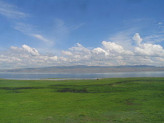
Lake Gusinoye is the name of a body of fresh water in the Republic of Buryatia, Russia.

Bauntovsky District is an administrative and municipal district (raion), one of the twenty-one in the Republic of Buryatia, Russia. It is located in the northeast of the republic. The area of the district is 66,816 square kilometers (25,798 sq mi). Its administrative center is the rural locality of Bagdarin. As of the 2010 Census, the total population of the district was 9,667, with the population of Bagdarin accounting for 49.0% of that number.

The Tsipa is the largest tributary of the Vitim in Buryatia, Russia. It is 692 kilometres (430 mi) long, and has a drainage basin of 42,200 square kilometres (16,300 sq mi). Maksim Perfilyev was the first Russian to reach the Tsipa in 1640.

Busani is the name of a body of fresh water in the Bauntovsky District, Buryatia, Russia. The name originated in the Evenki language, meaning "where people drown".

Vitim Plateau is a plateau in Buryatia and Zabaykalsky Krai, Russia. The plateau is sparsely populated, the main settlements are Romanovka and Bagdarin. An area of the plateau is an ancient volcanic field with a number of cinder cones and volcanoes, the last of which was active about 810,000 years before present.

Kurort Baunt is a rural locality in Bauntovsky District, Republic of Buryatia, Russia. The population was 39 as of 2010. There are 7 streets.

Lake Pekulney is a lake of Anadyr District, Chukotka Autonomous Okrug, Russia. The lake has a basin area of 435 km2 (168 sq mi) which makes it the second largest lake in the Chukotka Autonomous Okrug after Lake Krasnoye, and the 27th largest in area in Russia.

The South Siberian Mountains are one of the largest mountain systems of the Russian Federation. The total area of the system of mountain ranges is more than 1.5 million km². The South Siberian Mountains are located in the Siberian and Far Eastern Federal Districts of Russia, as well as partly in Mongolia. The territory of the mountain system is one of the Great Russian Regions.

The Southern Muya Range is a mountain range in Buryatia and Zabaykalsky Krai, Russia, part of the Stanovoy Highlands. The highest point of the range is 3,067 m high Muisky Gigant; another important peak is 2363 m high Mount Shaman.

The Upper Angara Range is a mountain range in Buryatia and Irkutsk Oblast, Russia, part of the Stanovoy Highlands.
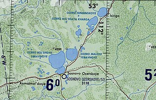
Isinga is a fresh water body in the Yeravninsky District, Buryatia, Russia.
Maly Yeravna is a fresh water body in the Yeravninsky District, Buryatia, Russia. There are two inhabited places by the lake, Tuldun in the northwestern shore and Shiringa in the northeastern.

Ikat Range is a mountain range in Buryatia, Russia. It runs in a parallel direction to the Baikal Rift. The range is named after two small rivers sharing the name "Ikat" which have their sources in opposite slopes of the range one is a tributary of the Gargi and the other a tributary of the Vitimkan.

Kapylyushi or Kapylyushy is a body of fresh water in the Bauntovsky District, Buryatia, Russia. The name originated in an Evenki word.

The Tsipikan is a river in Buryatia, Russia. It is the second largest tributary of the Tsipa, after the Amalat, of the Vitim basin. The river is 329 kilometres (204 mi) long, and has a drainage basin of 6,710 square kilometres (2,590 sq mi). There is gold mining in the banks of the river.

Dorong is a body of fresh water in the Bauntovsky District, Buryatia, Russia. The name originated in an Evenki word.
Yeravna-Khorga Lake System is a group of relatively shallow fresh water bodies in the Yeravninsky District, Buryatia, Russia. The villages of Isinga, Khorga, Tuldun, Gunda, Shiringa, Garam, as well as Sosnovo-Ozerskoye, the district capital, are located near the lakes.

The Bolshoy Khapton is a mountain range in Bauntovsky District, Buryatia, Russia.

Nichatka is a fresh water body in the Kalarsky District, Zabaykalsky Krai, Russia. The lake has an area of 37.3 km2 (14.4 sq mi). The name of the lake comes from the Evenki language word for "fish".


