Terranna Parish

Last updated
Terrana Parish
New South Wales

Goulburn.jpg

Location of Terranna in 1900 outlined in yellow
Australia New South Wales location map blank.svg
Red pog.svg
Terrana Parish
Coordinates 34°51′57″S149°40′02″E / 34.86583°S 149.66722°E / -34.86583; 149.66722 Coordinates: 34°51′57″S149°40′02″E / 34.86583°S 149.66722°E / -34.86583; 149.66722
LGA(s) Goulburn Mulwaree
County Argyle
Division Eastern

The Parish of Terrana is a Bounded Rural locality and parish of Argyle County, New South Wales, Australia. [1] [2]

Argyle County Cadastral in New South Wales, Australia

Argyle County was one of the original Nineteen Counties in New South Wales and is now one of the 141 Cadastral divisions of New South Wales. It includes the area around Goulburn. It is bounded by Lake George in the south-west, the Shoalhaven River in the east, and the Wollondilly River in the north-east.

New South Wales State of Australia

New South Wales is a state on the east coast of Australia. It borders Queensland to the north, Victoria to the south, and South Australia to the west. Its coast borders the Tasman Sea to the east. The Australian Capital Territory is an enclave within the state. New South Wales' state capital is Sydney, which is also Australia's most populous city. In March 2018, the population of New South Wales was over 7.9 million, making it Australia's most populous state. Just under two-thirds of the state's population, 5.1 million, live in the Greater Sydney area. Inhabitants of New South Wales are referred to as New South Welshmen.

Australia Country in Oceania

Australia, officially the Commonwealth of Australia, is a sovereign country comprising the mainland of the Australian continent, the island of Tasmania and numerous smaller islands. It is the largest country in Oceania and the world's sixth-largest country by total area. The neighbouring countries are Papua New Guinea, Indonesia and East Timor to the north; the Solomon Islands and Vanuatu to the north-east; and New Zealand to the south-east. The population of 25 million is highly urbanised and heavily concentrated on the eastern seaboard. Australia's capital is Canberra, and its largest city is Sydney. The country's other major metropolitan areas are Melbourne, Brisbane, Perth and Adelaide.

The area is similar to the locality of Tirrannaville, which partly lies in the Goulburn Parish.

Tirrannaville Town in New South Wales, Australia

Tirrannaville is a locality in the Goulburn Mulwaree Council, New South Wales, Australia. It is located about 11 km south of Goulburn on the road to Braidwood. It was formerly called Terranna, which is the name of the parish covering most of the locality. The northern part of the defined locality, including the small settlement of Tirrannaville and cemetery, is in the parish of Goulburn. At the 2016 census, it had a population of 237. The locality mostly consists of grazing land.

History

The area was first inhabited by the Gundungurra people, [3] [4] [5] and by the mid 1840s the NSW colonial government had granted numerous land grants in area, beginning white settlement. A Public School was established in 1869. The area is today predominantly used for agriculture though it lies in the Sydney-Canberra transit corridor.

Indigenous Australians are the Aboriginal and Torres Strait Islander people of Australia, descended from groups that existed in Australia and surrounding islands before British colonisation. The time of arrival of the first Indigenous Australians is a matter of debate among researchers. The earliest conclusively human remains found in Australia are those of Mungo Man LM3 and Mungo Lady, which have been dated to around 50,000 years BP. Recent archaeological evidence from the analysis of charcoal and artefacts revealing human use suggests a date as early as 65,000 BP. Luminescence dating has suggested habitation in Arnhem Land as far back as 60,000 years BP. Genetic research has inferred a date of habitation as early as 80,000 years BP. Other estimates have ranged up to 100,000 years and 125,000 years BP.

Colony of New South Wales British colony which later became a state of Australia

The Colony of New South Wales was a colony of the British Empire from 1788 to 1900, when it became a State of the Commonwealth of Australia. At its greatest extent, the colony of New South Wales included the present-day Australian states of New South Wales, Queensland, Victoria, Tasmania, and South Australia, as well as New Zealand. The first "responsible" self-government of New South Wales was formed on 6 June 1856 with Sir Stuart Alexander Donaldson appointed by Governor Sir William Denison as its first Colonial Secretary.

State schools are generally primary or secondary schools mandated for or offered to all children without charge, funded in whole or in part by taxation. These schools are generally inclusive (non-selective) in admitting all students within the geographical area that they serve.

Related Research Articles

Goulburn River National Park Protected area in New South Wales, Australia

The Goulburn River National Park is a national park located in New South Wales, Australia, 213 kilometres (132 mi) northwest of Sydney and it is 35 kilometres (22 mi) south-west of Merriwa. The Goulburn River National Park is located in the Hunter Valley region and covers approximately 90 kilometres (56 mi) of the Goulburn River. It is near the towns of Sandy Hollow, Denman, Merriwa, and Mudgee.

Goulburn, New South Wales Town in New South Wales, Australia

Goulburn is a regional city in the Southern Tablelands of New South Wales, Australia approximately 195 kilometres (121 mi) south-west of Sydney, Australia, and 90 kilometres (56 mi) north-east of Canberra. It was proclaimed as Australia's first inland city through letters patent by Queen Victoria in 1863. Goulburn had a population of 22,890 at the 2016 census. Goulburn is the seat of Goulburn Mulwaree Council.

Goulburn River (New South Wales) river in New South Wales, Australia

Goulburn River, a perennial river of the Hunter River catchment, is located in the Upper Hunter region of New South Wales, Australia.

Wollondilly River river in Australia

The Wollondilly River, an Australian perennial river that is part of the Hawkesbury–Nepean catchment, is located in the Southern Tablelands and Southern Highlands regions of New South Wales. The river meanders from its western slopes near Crookwell, flowing south-east through Goulburn, turning north-east to near Bullio, flowing north-west to Barrallier, before finally heading north-easterly into its mouth at Lake Burragorang.

Towrang Town in New South Wales, Australia

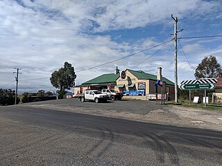
Towrang is a village in the Southern Tablelands of New South Wales, Australia, in Goulburn Mulwaree Council. It is approximately 13 kilometres (8.1 mi) before Goulburn on the Hume Highway 180 kilometres (110 mi) south from Sydney. At the 2016 census, Towrang had a population of 171.

Parish of Marulan Cadastral in New South Wales, Australia

The Parish of Marulan is a parish of Argyle County located with the Goulburn Mulwaree local government area, which includes the towns of Marulan and Marulan South. The parish is bounded by Barbers Creek to the east, a small part of the Shoalhaven River to the south-east, and Jerrara Creek to the south. The Hume Highway and the Southern Highlands railway line run through the parish. Jerrara Road and Marulan South Road are other main roads in the area.

Parish of Tarago Cadastral in New South Wales, Australia

The Parish of Tarago is a parish of Argyle County. It does not actually contain the town of Tarago, which is located further to the south-east in the Parish of Mulwaree.

The Parish of Wologorong is a parish of Argyle County, New South Wales, Australia.

Parish of Goulburn Cadastral in New South Wales, Australia

The Parish of Goulburn is a parish of Argyle County which includes most of the city of Goulburn, New South Wales.

Parish of Towrang Cadastral in New South Wales, Australia

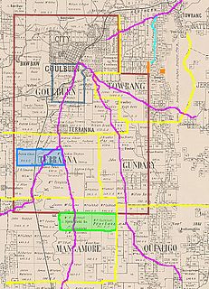
The Parish of Towrang is a parish of Argyle County located to the south-east of Goulburn, and including some of its outer suburbs such as Goulburn North, and the area to the east of the Wollondilly River and Mulwaree Ponds. The Goulburn War Memorial is also located in this parish. The village of Towrang is located at the north-eastern edge of the parish, with Towrang creek part of the boundary in this area.

The Parish of Nattery is a parish of Argyle County located between Goulburn and Marulan in New South Wales. It is just east of the village of Towrang and includes the locality of Carrick. The Wollondilly River is the boundary in the north-west. Jerraba creek is part of the boundary in the south-east. The Southern Highlands railway line runs through the northern end of the parish, to the east of the Wollondilly river. The Hume Highway passes through the middle of the parish.

Merriwa River, a perennial river of the Hunter River catchment, is located in the Upper Hunter region of New South Wales, Australia.

Grabben Gullen Town in New South Wales, Australia

Grabben Gullen is a small village in Upper Lachlan Shire, New South Wales, Australia. At the 2016 census, it had a population of 253. It is located between Crookwell and Gunning.

Currawang Cadastral in New South Wales, Australia

Currawang is a locality in the Queanbeyan–Palerang Regional Council, on the edges of Upper Lachlan Shire and Goulburn-Mulwaree Council, in New South Wales, Australia. It is located to the north of Lake George. It shares its name with the Currawang Parish of Argyle County, in which it is located. This was formerly known as the parish of Currowang. Both names derive from an Aboriginal word for the spearwood tree.

Parish of Milbang Cadastral in New South Wales, Australia

The Parish of Milbang is a parish of Argyle County, New South Wales, Australia, located at 34.4954°S 149.2604°E

Parish of Baw Baw Cadastral in New South Wales, Australia

The Parish of Baw Baw is a parish of Argyle County, New South Wales, Australia. It is located in to the west of Goulburn, in Goulburn Mulwaree Council at 34°42′54″S, 149°38′04″E.

Wollogorang, New South Wales Town in New South Wales, Australia

Wollogorang is a locality in the Upper Lachlan Shire and Goulburn Mulwaree Council, New South Wales, Australia. A small part of the locality is in Queanbeyan–Palerang Regional Council. It is located about 35 km southwest of Goulburn and 61 km northeast of Canberra. It lies on both sides of the Federal Highway and on the southern side of the Hume Highway. They intersect nearby to the northeast in the locality of Yarra. At the 2016 census, it had a population of 67.

Nanima Town in New South Wales, Australia

Nanima is a locality in the Yass Valley Council area, New South Wales, Australia. It lies on the both sides of the Murrumbateman Road between Murrumbateman and Gundaroo, about 37 km north of Canberra. At the 2016 census, it had a population of 165.

Quorrobolong, New South Wales Suburb of Cessnock, New South Wales, Australia

Quorrobolong is a small locality in the Hunter Region of New South Wales, Australia. It is located 11 km (7 mi) southeast of the town of Cessnock and is adjacent to Watagans National Park.

Nandi, New South Wales

Nandi Parish is a bounded rural locality and civil parish of Gowen County, in New South Wales.

References

  1. New South Wales Parish maps preservation project.
  2. Robert McLean, The New atlas of Australia : the complete work containing over one hundred maps and full descriptive geography of New South Wales, Victoria, Queensland, South Australia and Western Australia, together with numerous illustrations and copious indices (Sydney :J. Sands, [1886) Map 11.
  3. Dharag Neighbours.
  4. Encyclopaedia of Aboriginal Australia, Goulburn:Aborigines, Archive associated with Australia Street project(University of Technology, Sydney, 2006
  5. Norman Tindall, Gandangara (NSW) Aboriginal Tribes of Australia, (South Australian Museum, 2006).