
The Great Dividing Range, or the Eastern Highlands, is Australia's most substantial mountain range and the third longest land-based range in the world. It stretches more than 3,500 kilometres (2,175 mi) from Dauan Island off the northeastern tip of Queensland, running the entire length of the eastern coastline through New South Wales, then into Victoria and turning west, before finally fading into the central plain at the Grampians in western Victoria. The width of the range varies from about 160 km (100 mi) to over 300 km (190 mi). The Greater Blue Mountains Area, Gondwana Rainforests, and Wet Tropics of Queensland World Heritage Areas are located in the range.

The Blue Mountains are a mountainous region and a mountain range located in New South Wales, Australia. The region borders on Sydney's metropolitan area, its foothills starting about 50 kilometres (31 mi) west of centre of the state capital. The public's understanding of the extent of the Blue Mountains is varied, as it forms only part of an extensive mountainous area associated with the Great Dividing Range. Officially the Blue Mountains region is bounded by the Nepean and Hawkesbury rivers in the east, the Coxs River and Lake Burragorang to the west and south, and the Wolgan and Colo rivers to the north. Geologically, it is situated in the central parts of the Sydney Basin.
The Ngunawal are an indigenous Australian people of southern New South Wales.

Towrang is a village in the Southern Tablelands of New South Wales, Australia, in Goulburn Mulwaree Council. It is approximately 13 kilometres (8.1 mi) before Goulburn on the Hume Highway 180 kilometres (110 mi) south from Sydney. At the 2016 census, Towrang had a population of 171.
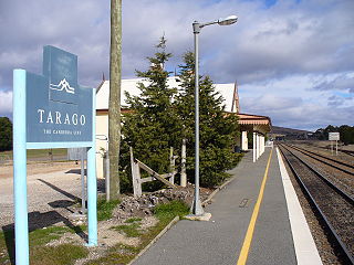
Tarago is a town in the Southern Tablelands of New South Wales, Australia in Goulburn Mulwaree Council. Part of the defined locality, which includes a large area of grazing country, is on the eastern shore of Lake George in the area of the Queanbeyan–Palerang Regional Council. The town is situated 39 kilometres south of the city of Goulburn and 69 kilometres northeast of Canberra, the capital city of Australia. It is located on the Goulburn-Braidwood road. The town is notable for recent renewable energy projects in the surrounding districts.

Lands administrative divisions of Australia are the cadastral divisions of Australia for the purposes of identification of land to ensure security of land ownership. Most states term these divisions as counties, parishes, hundreds, and other terms. The eastern states of Queensland, New South Wales, Victoria and Tasmania were divided into counties and parishes in the 19th century, although the Tasmanian counties were renamed land districts in the 20th century. Parts of South Australia (south-east) and Western Australia (south-west) were similarly divided into counties, and there were also five counties in a small part of the Northern Territory. However South Australia has subdivisions of hundreds instead of parishes, along with the Northern Territory, which was part of South Australia when the hundreds were proclaimed. There were also formerly hundreds in Tasmania. There have been at least 600 counties, 544 hundreds and at least 15,692 parishes in Australia, but there are none of these units for most of the sparsely inhabited central and western parts of the country.

Murray County was one of the original Nineteen Counties in New South Wales and is now one of the 141 Lands administrative divisions of New South Wales. It included the area which is now part of Canberra and as far north as Lake George and Yass. It was originally bounded on the west by the Murrumbidgee River, on the east by the Shoalhaven River and on the north by the Yass River. A large area of the county was transferred to the Commonwealth government in 1909 in the Seat of Government Acceptance Act to make part of the Australian Capital Territory, along with land in Cowley County. Since then, the ACT border is now part of the western boundary. Part of the ACT border is determined by property boundaries in the Parish of Keewong, in the County of Murray; specifically the southern end of portions 177, 218, 211, 36, and 38. This is mentioned in the Seat of Government Acceptance Act of 1909.

Collector is a small village on the Federal Highway in New South Wales, Australia halfway between Goulburn and the Australian Capital Territory. It is seven kilometres north of Lake George. At the 2016 census, Collector and the surrounding district had a population of 313 people.

The Parish of Tarago is a parish of Argyle County. It does not actually contain the town of Tarago, which is located further to the south-east in the Parish of Mulwaree.
The Parish of Wologorong is a parish of Argyle County, New South Wales, Australia.

The Parish of Towrang is a parish of Argyle County located to the south-east of Goulburn, and including some of its outer suburbs such as Goulburn North, and the area to the east of the Wollondilly River and Mulwaree Ponds. The Goulburn War Memorial is also located in this parish. The village of Towrang is located at the north-eastern edge of the parish, with Towrang creek part of the boundary in this area.
The Parish of Nattery is a parish of Argyle County located between Goulburn and Marulan in New South Wales. It is just east of the village of Towrang and includes the locality of Carrick. The Wollondilly River is the boundary in the north-west. Jerraba creek is part of the boundary in the south-east. The Southern Highlands railway line runs through the northern end of the parish, to the east of the Wollondilly river. The Hume Highway passes through the middle of the parish.

Mooki River, a perennial stream that is part of the Namoi catchment within the Murray–Darling basin, is located in the Northern Tablelands district of New South Wales, Australia.

Carwoola is a locality in the state of New South Wales, Australia. It is immediately to the south of the Kowen district, which is located in the Australian Capital Territory. The Molonglo River passes through the Carwoola area before opening out into the Molonglo Plains. The Kings Highway and Captains Flat Road are the two major through routes. Carwoola is part of the Queanbeyan-Palerang Regional Council and the Southern Tablelands geographic area. The area also roughly aligns with the original Carwoola Parish.
The Parish of Milbang is a parish of Argyle County, New South Wales, Australia, located at 34.4954°S 149.2604°E
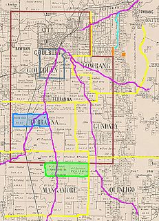
The Parish of Baw Baw is a parish of Argyle County, New South Wales, Australia. It is located in to the west of Goulburn, in Goulburn Mulwaree Council at 34°42′54″S, 149°38′04″E.
The Parish of Terrana is a parish of Argyle County, New South Wales, Australia.

Wollogorang is a locality in the Upper Lachlan Shire and Goulburn Mulwaree Council, New South Wales, Australia. A small part of the locality is in Queanbeyan–Palerang Regional Council. It is located about 35 km southwest of Goulburn and 61 km northeast of Canberra. It lies on both sides of the Federal Highway and on the southern side of the Hume Highway. They intersect nearby to the northeast in the locality of Yarra. At the 2016 census, it had a population of 67.


