Thackery, Ohio

Last updated
Thackery and surrounding countryside Thackery regional from the air.jpg
Thackery and surrounding countryside
Location of Thackery, Ohio OHMap-doton-Thackery.png
Location of Thackery, Ohio

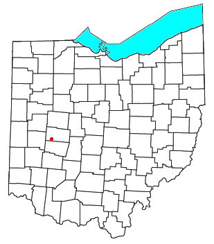
Thackery is an unincorporated community in southeastern Jackson and southwestern Mad River Townships in Champaign County, Ohio, United States. [1] It lies along State Route 55, southwest of the city of Urbana, [2] the county seat of Champaign County. [3]

History

A post office called Thackery was established in 1894, and remained in operation until 1965. [4] The community was named for its founder, one Mr. Thackery. [5]

Related Research Articles

Mutual, Ohio Village in Ohio, United States

Mutual is a village in Champaign County, Ohio, United States. The population was 104 at the 2010 census.

Berryman is an unincorporated community on the border between Crawford and Washington counties in the U.S. state of Missouri. Located along Route 8, it lies in the Mark Twain National Forest, approximately sixteen miles west of Potosi. Courtois Creek flows under Route 8, just west of the village. Berryman Recreation Area and trail lie to the northeast of the village.

Roundhead, Ohio unincorporated community in Roundhead Township

Roundhead is an unincorporated community in southeastern Roundhead Township, Hardin County, Ohio, United States. Although it is unincorporated, it has a post office, with the ZIP code of 43346.

Cable, Ohio human settlement in Ohio, United States of America

Cable is an unincorporated community in central Wayne Township, Champaign County, Ohio, United States. Although it is unincorporated, it has a post office, with the ZIP code of 43009.

Springhills, Ohio human settlement in Ohio, United States of America

Springhills is an unincorporated community in northwestern Harrison Township, Champaign County, Ohio, United States. It lies at the intersection of State Route 245 with Crowl and Springhill-DeGraff Roads. Graves Creek, a subsidiary of the Great Miami River through Stony Creek, runs along the western edge of Springhills. It is located 6 miles (9.5 km) west of West Liberty and 11.5 miles (18.5 km) northwest of Urbana, the county seat of Champaign County.

Hepburn, Ohio unincorporated community in Dudley Township, Hardin County, Ohio, United States of America

Hepburn is an unincorporated community in northern Dudley Township, Hardin County, Ohio, United States. It lies at the intersection of County Roads 144 and 227, 7 12 miles (12.1 km) east of the center of the city of Kenton, the county seat of Hardin County. Along the south side of the community runs the Scioto River. The community is served by the Kenton (43326) post office.

Logansville, Ohio Unincorporated community in Ohio, United States

Logansville is an unincorporated community in central Pleasant Township, Logan County, Ohio, United States. It lies along State Route 47 at its intersection with County Road 24. The Great Miami River flows southward along the western edge of Logansville. The community lies 2½ miles (4 km) north of the village of De Graff and 9 miles west of the city of Bellefontaine, the county seat of Logan County. It is located at 40°20′44″N83°55′50″W, and its altitude is 1,010 feet (308 m).

Kennard, Ohio human settlement in Ohio, United States of America

Kennard is an unincorporated community in eastern Salem Township, Champaign County, Ohio, United States. It lies at the intersection of Gray and Kennard Roads, less than 2 miles southwest of State Route 245. The headwaters of Kings Creek, a tributary of the Mad River, flow past Kennard. It is located approximately 10 miles (16 km) northwest of the city of Urbana, the county seat of Champaign County.

Millerstown, Champaign County, Ohio unincorporated community in Johnson Township, Champaign County, Ohio

Millerstown is an unincorporated community in eastern Johnson Township, Champaign County, Ohio, United States. It lies at the intersection of Heck Hill, Ward, and Zimmerman Roads, 2 12 miles (4.0 km) north of U.S. Route 36. Nettle Creek, a tributary of the Mad River, flows past Millerstown. It is located approximately 4 miles northeast of the village of St. Paris and 10 miles (16 km) west-northwest of the city of Urbana, the county seat of Champaign County.

Brokensword, Ohio human settlement in Ohio, United States of America

Brokensword is an unincorporated community on the border between the Holmes and Lykens townships of Crawford County, Ohio, United States. Located at the intersection of the concurrent State Routes 19 and 100 with Brokensword Road, it is six miles north and two miles west of the city of Bucyrus, the county seat. Broken Sword Creek flows a short distance to the south of the community.

Westminster, Ohio human settlement in Ohio, United States of America

Westminster is an unincorporated community in western Auglaize Township, Allen County, Ohio, United States. It lies along State Route 117 just north of its intersection with State Route 196, 6½ miles north of Waynesfield and 7 12 miles (12.1 km) southeast of the downtown part of the city of Lima, the county seat of Allen County. The upper reaches of the Auglaize River flow past the community.

Tawawa, Ohio human settlement in Ohio, United States of America

Tawawa is an unincorporated community in northeastern Green Township, Shelby County, Ohio, United States. It lies along State Route 29 less than one mile away from the Champaign County border. Mosquito Creek, a tributary of the Great Miami River, flows northwestward along the southern edge of Tawawa. The community lies 8 miles southeast of the city of Sidney, the county seat of Shelby County.

Assumption, Ohio human settlement in Ohio, United States of America

Assumption is a small unincorporated community in southern Amboy Township, Fulton County, Ohio, United States. A part of the Toledo Metropolitan Area, it lies seven miles from the northern edge of Swanton. It is located at roughly 41°40'N, 83°55'W.

Mexico, Ohio Unincorporated community in Ohio, United States

Mexico is an unincorporated community in northeastern Tymochtee Township, Wyandot County, Ohio, United States. Located at 40°59′11″N83°11′36″W, it lies at an elevation of 810 feet.

Carysville is an unincorporated community in Champaign County, in the U.S. state of Ohio.

Crayon is an unincorporated community in Champaign County, in the U.S. state of Ohio.

Kingscreek is an unincorporated community in Champaign County, in the U.S. state of Ohio.

Middletown, Champaign County, Ohio human settlement in United States of America

Middletown is an unincorporated community in Champaign County, in the U.S. state of Ohio.

Northville is an unincorporated community in Champaign County, in the U.S. state of Ohio.

Terre Haute is an unincorporated community in Champaign County, in the U.S. state of Ohio.

References

  1. U.S. Geological Survey Geographic Names Information System: Thackery
  2. DeLorme. Ohio Atlas & Gazetteer. 7th ed. Yarmouth: DeLorme, 2004, p. 56. ISBN   0-89933-281-1.
  3. "Find a County". National Association of Counties. Retrieved 2011-06-07.
  4. "Champaign County". Jim Forte Postal History. Retrieved 21 December 2015.
  5. Middleton, Evan P. (1917). History of Champaign County, Ohio: Its People, Industries and Institutions. B.F. Bowen. p.  898.

Coordinates: 40°03′20″N83°55′08″W / 40.05556°N 83.91889°W / 40.05556; -83.91889