
Muvattupuzha is a town, municipality in the midlands directly to the east of Kochi in Ernakulam district, Kerala, India. It is located about 36 km (22 mi) from downtown Kochi, and is a growing urban centre in central Kerala. The town is also the starting point of the Muvattupuzhayar, which is a confluence formed by three rivers: the Thodupuzhayar, Kaliyar, and Kothayar.
Edappally is a ward of Kochi, Kerala. The name is also used to refer to adjacent wards of Kalamassery and Thrikkakkara municipalities. Edappally is a major commercial centre as well as a prominent residential region. Edappally junction is one of the busiest junctions in the city.
Vennala is a ward of Kochi, Kerala. It was one of the early panchayats of Kerala, that was amalgamated with other panchayats during the formation of Kochi corporation. Located at around 6 km from the city center, it spans the area from Alinchuvadu to Arkakkadavu and from Kottenkavu to Padivattom.
Kochi is a major port city in the Indian state of Kerala. The city is widely known as the commercial or economic capital of the state of Kerala.

Palarivattom is a ward of Kochi, Kerala. The region makes a four-directional intersection at its highway signal point on the Kochi Bypass, which leads to :

Kadavanthra is a ward in downtown Kochi, Kerala. It is bounded by the S.A Road to the north and the Giri Nagar canal in the west. Kadavanthra is a major commercial centre of Kochi, and a prime residential area. In recent years, the ward has undergone rapid development to become one of Kochi's highest-valued regions. The S.A Road is Kadavanthra's main arterial roads, and connects it to the Vyttila interchange in the east.
Cheranallur or Cheranellore or Cheranelloor is a suburb of Kochi city in the state of Kerala, India and lies on the banks of the Periyar River. According to tradition, the area was named by its earlier inhabitants who found this place very fertile and beautiful. The name in its local language Malayalam means "Good Village of Cheras".

Maradu is a municipality in the Ernakulam district of Kerala, India. Maradu is located 6.1 km (3.8 mi) east of the Kochi city centre, and is a part of the Kochi metropolitan area. Maradu is an inner suburb of Kochi, located immediately south of Vyttila and connected to Thevara in the west by the Kundanoor bypass. National highways NH 85, NH 966 B and NH 66 passes through Maradu and has played a vital role in the development of the area.

Ollur is a major suburban area and an old commercial town in the city of Thrissur of Kerala state, South India. It is about five kilometres (3.1 mi) away from Swaraj Round on old National Highway 47 (India) towards Kochi. From ancient time onwards, Ollur was a major business centre in Thrissur district. Now, this geographical area is part of Thrissur Municipal Corporation. It is situated between Kuriachira and Thalore on the National Highway. However, a specific identity for this geographical region is still there due to the urban setting of this region and its important religious institutions.

Olavakkode is a region in Palakkad city, Kerala, India. It is composed of two main areas: the Kavilpad and the Railway Colony. Olavakkode is located 4 km from Palakkad city and lies on National Highway 966.It is one of the major suburbs of Palakkad city as Palakkad Junction railway station one of the major stations of the city is located there.
Nettoor is a region in the city of Kochi. It is around 5 km (3.1 mi) from Vytilla Junction and around 8 km (5.0 mi) from Ernakulam Junction Railway Station. Nettoor is located on Panangad Island and is a part of Maradu Municipality.
Vyttila, IPA: [ʋɐjt̺ːilɐ], is a ward of Kochi, Kerala. The Vyttila junction is one of the busiest as well as one of the largest intersections in Kerala. This node intersects the main north–south artery of the state of Kerala, namely, the Kochi Bypass, with three city roads of Kochi viz, the S. A. Road, the Vyttila-Petta Road, and the Thammanam Road.

Kaloor is a downtown region in the city of Kochi, in the state of Kerala, India. It is two kilometres (1.2 mi) from the Ernakulam North Railway Station. Kaloor Junction is also the name of a major intersection in this part of the city, intersecting the two major arteries of downtown Kochi, namely Banerji Road and the Kaloor-Kadavanthra Road. The nearest major intersections are Palarivattom to the east and Lissie Junction to the west.
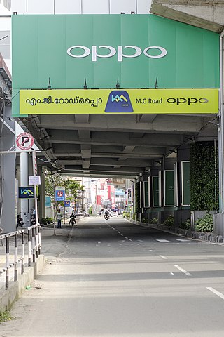
Mahatma Gandhi Road, popularly known as M. G. Road, is the main artery as well as the commercial high street of the city of Kochi, in the state of Kerala, India. The road lies north-south with its boundaries at the Venduruthy bridge, Thevara in the south, and the Madhava Pharmacy Junction in the north, where it intersects the Banerji Road. The road was earlier part of the NH 47A and was later handed over to Kochi Municipal Corporation. The highway was earlier known as Seventy Feet road. The total distance of the road is 4.5 kilometres (2.8 mi).
Sahodaran Ayyappan Road, popularly known as S.A Road is one of the most important and the second main arterial road of CBD Kochi city ; it is supposed to be the busiest and most congested road in the city of Kochi, which run in east-west direction and the shortest road connecting the two main iconic junctions in the city. The road connects the MG Road in west with Vyttila Junction & Hub in east and continues further as Tripunithura Road that connects to Tripunithura, hence termed as the back bone road of Kochi.
This is a list of areas and neighbourhoods in Cochin by region.

The Kochi Bypass is a segment of NH66(National Highway 66) that bypasses the CBD of the city of Kochi in Kerala, India. The highway stretches 17 km from Edapally in the Ernakulam district to Aroor in Alappuzha district, via. Palarivattom, Vyttila, Kundannoor, Madavana, Kumbalam. The Government of Kerala began the preliminary works in 1973. After a slow progress, it was partially opened for traffic in the beginning years of the 1980s. The section between Edapally and Vyttila had four lanes from the beginning. The rest of the carriageway was also upgraded to different sections of 4 lane, 5 lane and 6 lanes by 2010
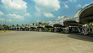
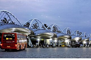
Vyttila Mobility Hub is an integrated transit terminal in the city of Kochi. It is designed as a converging point of various forms of public transportation, such as local and long-distance buses, metro rail and inland water transport. It is planned over an area of 37 acres (150,000 m2) in Vyttila, making it one of the largest bus termini in India.

Panampilly Nagar is a ward of Kochi, Kerala.. It is an upscale area of downtown Kochi, with both commerical and residential developments. It is a busy upmarket residential area in Kadavanthra region just 1 km east of M.G Road, the center of Kochi city.
Kathrikadavu is a region in the city of Kochi, in the state of Kerala, India. It lies almost midway between the two major intersections (junctions) in Kochi, namely Kaloor and Kadavanthra. Kathrikadavu is mainly a residential area, though of late more and more commercial establishments are being set up here.
