
Datia, also known as Daityavakra is the district headquarter of the Datia District in north central Madhya Pradesh, a state of Central India. It is an ancient town, mentioned in the Mahabharata ruled by King Dantavakra. The city is 78 km from Gwalior, 325 km south of New Delhi and 344 km north of Bhopal. About 18 km from Datia is Sonagiri, a sacred Jain hill. Datia is also about 28 km from Jhansi and 52 km from Orchha. The nearest airport is at Gwalior. It was formerly the seat of the eponymous princely state in the British Raj. Datia is situated near Gwalior and on the border with Uttar Pradesh.

Ambalappuzha is a small town in the Alappuzha district of Kerala state, India. It is located 14 km (8.7 mi) south of Alappuzha which is the district headquarters.

Madurai district is one of the 38 districts of the state of Tamil Nadu in southeastern India. The city of Madurai serves as the district headquarters. It houses the famous Sri Meenakshi Sundareshwarar temple and is situated on the banks of the river Vaigai. Thiruparankundram is one of the major tourist place in the district. As of 2011, the district had a population of 3,038,252 with a sex-ratio of 990 females for every 1,000 males. Aside from the city of Madurai, the larger towns are Melur, Vadipatti, Thirumangalam, Thirupparankundram, Peraiyur, and Usilampatti. It is an important hub for various film shootings. Alanganallur is a popular spot in the district for Jallikattu, as are Palamedu and Avaniyapuram.
Dholpur is a city in the Dholpur district in Rajasthan state of India. It is situated on the left bank of the famous Chambal river. The city is the administrative headquarters of Dholpur District.

Vengurla is a town in Sindhudurg district of Maharashtra, India just north of Goa. It is surrounded by a semicircular range of hills with lush green foliage mainly of cashew, mango, coconut, and different kinds of berry trees. The hills of Dabholi, Tulas, and Mochemad respectively lie in the north, the east, and the south of Vengurla, while the Arabian Sea is located on its west.
Thiruneermalai is a neighborhood in the city of Tambaram, situated within the Chennai Metropolitan Area, Tamil Nadu, India.

Vellore district is one of the 38 districts in the Tamil Nadu state of India. It is one of the eleven districts that form the north region of Tamil Nadu. Vellore city is the headquarters of this district. As of 2011, the district had a population of 1,614,242 with a sex ratio of 1,007 females for every 1,000 males. In 2017 Vellore district ranked eleventh in list of districts in Tamil Nadu by Human Development Index.
Kizhakkancherry is a gram panchayat in the Palakkad district, state of Kerala, India. It is a local government organisation that serves the villages of Kizhakkencheri-I and Kizhakkencheri-II. It was formed in the year of 1951 and is the fourth largest grama panchayath in Kerala. It covers an area of 112.56 km2 and comprises 22 wards. The boundaries are Vadakkencherry (north), Pananjeri (south), Vandazhy (east) and Kannambra (west). The village is located 37.4 km from the city of Palakkad and 34.9 km from Thrissur.

Azhikode is a coastal town and a suburb of Kannur city situated in Kannur district of Kerala, India. Azhikode town is divided into Azhikode North and Azhikode South. The northern end of the Azhikode North is called Azhikkal. The place is the birthplace of Sukumar Azhikode, an influential thinker and literary critic. It is about 7 km (4.3 mi) from Kannur city.
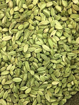
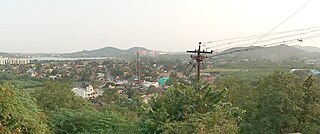
Haveri is a city in Karnataka, India. It is the administrative headquarters of Haveri district. Haveri is famous for its cardamom garlands and Byadagi red chillies. Around 25 km away, there is a place called Bada, which is the birthplace of the poet Kanakadasa.
Navaikulam is a panchayat in Varkala Taluk, it the northernmost tip of Thiruvananthapuram district in the state of Kerala, India. It is situated 11km east of Varkala town and 37km north of Trivandrum City along NH66. Navaikulam shares many cultural and linguistic similarities with the neighboring Kollam district or Central Travancore.

Kuknoor is a town in Kukanoor taluk in the Koppal District of the Indian state of Karnataka, which is located about 40 km northwest of Hospet and 7 km from the Mahadeva Temple in Itagi. Kuknoor is known for the temples of the Rashtrakutas and Chalukyas in the town, with the most notable being the Navalinga Temple.

Cherukunnu is a census town in Kannur district in the Indian state of Kerala. Cherukunnu town is located on Valapattanam-Pappinisseri-Pazhayangadi main road, situated to the south of the Pazhayangadi in Kannur District in Kerala.
Kizhakkekallada, also known as East Kallada, is a large village in the Kollam district in the state of Kerala, India. It is located about 20 kilometres (12 mi) northeast of Kollam.
Manambur is a village in Varkala Taluk of Trivandrum district in the state of Kerala, India. It is situated 9km south-east of Varkala Town and 35km north of State Capital city Trivandrum.Manamboor Subrahmanyaswami temple is famous for kavadi festival.
Benadi is a village in the North-Western region of Karnataka state near Maharashtra Border in India. It is located in the Chikodi taluka of Belgaum district in Karnataka. Before it was a part of Bombay State and Princely state of Kolhapur. It is a part of Twin Village Aadi-Benadi. People who has origin from this village are known as Benadikar.
Hulagabali is a village in the southern state of Karnataka, India. It is located in the Athani taluk toward north-east of Belgaum district. The basic occupation in Hulagabali is agriculture and there are also many landlords in the village who are famous in agriculture. Sugarcane is the highest percentage of agriculture as per the survey. There are quite a few temples in the village. The Birappa temple located in this village is well known in surrounding villages. Birappa temple has a large fair and festivities twice a year that draws huge crowd in the region. Sri Sangameshwara temple stands at the juncture of River Krishna and River Agrani. The famous landlords are Patil and Gaddekars.
Kabbur is a town in the southern state of Karnataka, India. It is located in the Chikodi taluk of Belgaum district in Karnataka.
Banavara is a town in the south Indian state of Karnataka.
Belagola , sometimes referred to as Mandya Belagola to distinguish it from Shravana Belagola, is a village in the southern state of Karnataka, India. It is located about 15 kilometers north-northwest of Mysuru city in the Shrirangapattana taluk of Mandya district in Karnataka. It is around 7 km from famous K.R.S Dam.

