Thiruvankulam

Last updated

Thiruvankulam
Census town
Thiruvankulam2.jpg
Shiva Temple
Coordinates: 9°56′37″N76°22′26″E / 9.943569°N 76.373904°E / 9.943569; 76.373904
CountryFlag of India.svg  India
State Kerala
District Ernakulam
Area
  Total10.49 km2 (4.05 sq mi)
Population
 (2011)
  Total23,160
  Density2,208/km2 (5,720/sq mi)
Languages
  Official Malayalam, English
Time zone UTC+5:30 (IST)

Thiruvankulam is a census town in Thrippunithura municipality, in Ernakulam district, Kerala, India. [1] The area is a part of the Kochi metropolitan area. NH 85 passes through Thiruvankulam. The Karingachira junction is the location of the southern terminus of the Seaport-Airport Road, which connects the Cochin International Airport and the Cochin Port. [2]

Contents

In the 13th and 14th centuries, Thiruvankulam was a border village between the Kingdom of Cochin and Kingdom of Travancore. The Kavaleeshwaram stream, now a canal, separated the two kingdoms. Thiruvankulam is the location of the Hill Palace, which was the imperial administrative office and official residence of the Cochin royal family.

In the present day, Thiruvankulam's proximity to the city as well as industrial areas comprising the Kochi refineries and allied industries have contributed to its growth. The economic development of Kochi, as well as the nearby refinery industry have resulted in Thiruvankulam emerging as a major residential area. [3]

Etymology

The name "Thiruvankulam" is derived from the Malayalam Thiru-vayaram-kulam[ citation needed ] (with vayar meaning "stomach, kulam meaning "pond", and Thiru- meaning "his"). The legend behind the name is related to Shiva and Parashurama. According to the legend, the Shiva temple at Thiruvankulam is one out of four other Shiva temples that Parasurama had built (with the other three temples located in Kureekkad, Perunninakulam and Trikkathara) when he saw Shiva spread across all these four places.

Demographics

Historical population
YearPop.±%
199118,412    
200121,713+17.9%
201123,160+6.7%
Source: [4]

As per the 2011 Indian census, the Thiruvankulam census town has a total population of 23,160 and a population density of 2,208 inhabitants per square kilometre (5,720/sq mi). Of this, 49.14% are male and 50.86% are female. 8.01% of the population is under 6 years of age. Scheduled Castes and Scheduled Tribes constitute 17.28% and 0.40% of the population respectively. The total literacy rate was 97.25% (98.37% for males and 96.18% for females), which is higher than the state average of 94% and the national average of 74.04%.

Religion

Religion in Thiruvankulam (2011)

   Hinduism (69.25%)
   Christianity (29.35%)
   Islam (0.71%)
  None (0.60%)
  Other (0.04%)

According to the 2011 census, Hindus are the majority with 69% of the population adhering to the religion. Christians form a significant minority, constituting 29% of the population. Muslims constitute 0.71% of the population. [5]

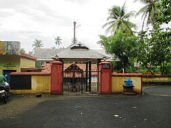
The St. George Cathedral, said to have been established in 722 AD, is an ancient church of the Nasrani community in the Thrippunithura region. The Shiva temple in Thiruvankulam, from which the place name originates, attracts many devotees for its unique festivals and rituals. [6]

Administration

Thiruvankulam is in Piravom assembly constituency.Thiruvankulam was administered by a special grade panchayat (village or non-urban habitation) under the Kerala Panchayati Raj Act. In 2010, as a result of the re-organization of administrative divisions in Kerala, Thiruvankulam panchayat merged with the neighbouring Tripunithura Municipality.

Places to visit

Hill Palace

Hill Palace is a large archaeological museum in Kerala situated in Thiruvankulam. It was the administrative office of the princely state of Kochi. Built in 1865, the palace complex that occupies a hill consists of 49 buildings in the traditional architectural style, spreading across in 54 acres (220,000 m2). The complex has an archaeological museum, a heritage museum, a deer park, a 'prehistoric' park and a children's park. The land surrounding the Hill Palace has rare Medicinal Plants as it used to be a medicinal garden nurtured by the royal gardeners.

The palace has been converted into a museum and is open to public all days except Mondays from 9:00 am to 12:30 pm and 2:00 pm to 4:30 pm.

A very well known Malayalam movie, Manichitrathazhu was shot in this palace.

Karingachira Church

A Jacobite Syrian Church was built in 722 AD near Hill Palace, Tripunitura. The church is named after Saint George. The Katthanar (Vicar) of Karingachira was considered the representative of the Nazarani community of the erstwhile Cochin State. The Saint Parumala Thirumeni was ordained as a deacon in this church in 1857 AD.

This church was elevated as a cathedral by Patriarch Ignatius Zakka I Iwas in 2004.

Economic activities

The village is home to large petroleum corporations as well as numerous small scale and cottage industries. TRACO Cable Company, a cable manufacturer, as well major oil corporations like Bharat Petroleum, Indian Oil Corporation, Hindustan Petroleum have their presence there. Agriculture, though it has fallen from the status of the prime means of livelihood in Thiruvankulam, is still in good shape. The major produces include coconuts, arecanuts, nutmeg, and pepper. Rice cultivation is on the decline. [7]

Most people are employed in the city of Kochi, major employers being the Kochi Refineries, HOC, FACT and the government of Kerala.[ citation needed ]

Related Research Articles

<span class="mw-page-title-main">Kochi</span> Metropolis in Kerala, India

Kochi, also known by its former name Cochin, is a major port city along the Malabar Coast of India bordering the Laccadive Sea. It is part of the district of Ernakulam in the state of Kerala. The city is also commonly referred to as Ernakulam. As of 2011, the Kochi Municipal Corporation had a population of 677,381 over an area of 94.88 km2, and the larger Kochi urban agglomeration had over 2.1 million inhabitants within an area of 440 km2, making it the largest and the most populous metropolitan area in Kerala. Kochi city is also part of the Greater Cochin development region and is classified as a Tier-II city by the Government of India. The civic body that governs the city is the Kochi Municipal Corporation, which was constituted in the year 1967, and the statutory bodies that oversee its development are the Greater Cochin Development Authority (GCDA) and the Goshree Islands Development Authority (GIDA).

<span class="mw-page-title-main">Chendamangalam</span> Town in Kerala, India

Chendamangalam is a small town and a panchayat in Paravur Taluk, Ernakulam district in the state of Kerala, India.

<span class="mw-page-title-main">Ernakulam district</span> District in Kerala, India

Ernakulam is one of the 14 districts in the Indian state of Kerala, and takes its name from the eponymous city division in Kochi. It is situated in the central part of the state, spans an area of about 2,924 square kilometres (1,129 sq mi), and is home to over 9% of Kerala's population. Its headquarters are located at Kakkanad. The district includes Kochi, also known as the commercial capital of Kerala, which is famous for its ancient churches, Hindu temples, synagogues and mosques.

<span class="mw-page-title-main">Angamaly</span> City in Kerala, India

Angamaly is a municipality in the Ernakulam district of Kerala, India. It is located 20 km (12.4 mi) north of the district collectorate in Thrikkakara and about 203 km (126.1 mi) north of the state capital Thiruvananthapuram. Angamaly is part of the Kochi metropolitan area and is located 24 km (14.9 mi) northeast of the Kochi city centre. As per the 2011 Indian census, Angamaly has a population of 33,465 people, and a population density of 1,640/km2 (4,200/sq mi).

<span class="mw-page-title-main">Aluva</span> Region in Kochi, Kerala, India

Aluva, is a municipality in the Ernakulam district of Kerala, India. It is part of the Kochi metropolitan area, 15 km (9.3 mi) north of the Kochi city centre. As per the 2011 Indian census, Aluva has a population of 22,428.

<span class="mw-page-title-main">Perumbavoor</span> Neighbourhood in Ernakulam, Kerala, India

Perumbavoor is a municipality in the Ernakulam district of Kerala, India. It is located 18 km (11.2 mi) north of the district collectorate in Thrikkakara and about 187 km (116.2 mi) north of the state capital Thiruvananthapuram. Perumbavoor is part of the Kochi metropolitan area and is located 26 km (16.2 mi) northeast of the Kochi city centre. As per the 2011 Indian census, Perumbavoor has a population of 28,110 people, and a population density of 2,065/km2 (5,350/sq mi).

<span class="mw-page-title-main">Thrippunithura</span> Municipality in Kerala, India

Thrippunithura, also spelled Tripunithura,, is a municipality in the Ernakulam district of Kerala, India. It is part of the Kochi metropolitan area, 7 km (4.3 mi) east of the Kochi city centre. As per the 2011 Indian census, Thrippunithura has a population of 69,390. A prominent historical region, Thrippunithura was the capital of the erstwhile Kingdom of Cochin. The Hill Palace situated in Thripunithura was the palace of Maharaja of Cochin, the ruler of Kingdom of Cochin. Thrippunithura is known for its rich culture which includes the annual Vrishchikotsavam festival that takes place at the Sree Poornathrayeesa Temple.

<span class="mw-page-title-main">Piravom</span> Municipality in Kerala, India

Piravom is a municipality in the Ernakulam district of Kerala, India. It is located 22 km (13.7 mi) south of the district collectorate in Thrikkakara and about 162 km (100.7 mi) north of the state capital Thiruvananthapuram. As per the 2011 Indian census, Piravom has a population of 27,229 people, and a population density of 927/km2 (2,400/sq mi).The majority of people living in Piravom are Syrian Christians.

<span class="mw-page-title-main">Kalamassery</span> Municipality in Kochi, India

Kalamassery is a municipality in the Ernakulam district of Kerala, India. It is a suburb and a prominent industrial region in the Kochi metropolitan area, and is located 9 km (5.6 mi) northeast of the Kochi city centre. It is located 7 km (4.3 mi) north of the district headquarters in Thrikkakara and about 212 km (131.7 mi) north of the state capital Thiruvananthapuram. As per the 2011 Indian census, Kalamassery has a population of 70,776 people, and a population density of 2,621/km2 (6,790/sq mi).

Pukkattupady is a suburb of the City of Kochi, in Ernakulam District, Kerala, India. It is in intersection of major bus route from Aluva Town via F.A.C.T and BPCL to Thrippunithura and Kolenchery via Kizhakkambalam and the routes from Perumbavoor to Ernakulam via NPOL or Edappally.

<span class="mw-page-title-main">Cheranallur</span> Suburb in Ernakulam, Kerala, India

Cheranallur or Cheranellore or Cheranelloor is a suburb of Kochi city in the state of Kerala, India and lies on the banks of the Periyar River. According to tradition, the area was named by its earlier inhabitants who found this place very fertile and beautiful. The name in its local language Malayalam means "Good Village of Cheras".

<span class="mw-page-title-main">Kochi metropolitan area</span> Metropolitan Area in Kerala, India

The Kochi metropolitan area or Kochi urban agglomeration is a metropolitan area consisting of Kochi and its satellite towns in Ernakulam district, Kerala, India. With a population of more than 2.1 million within an area of 440 km2, it is the most populous metropolitan area in Kerala.

Vazhakala is a neighbourhood region in the city of Kochi in Kerala, India. It is situated around 5 km (3 mi) from the city center and is part of Thrikkakkara Municipality. It can be classified as a typical residential area adjacent to schools, colleges and professional institutions.it has a history about 150 years mainly associated with age old churches and temples.

<span class="mw-page-title-main">Hill Palace, Tripunithura</span> Archeological museum, History museum in Kochi, India

Hill Palace is an archaeological museum and palace located in the Thrippunithura neighbourhood of Kochi, Kerala. It is the largest archeological museum in the state and was the imperial administrative office and official residence of the Cochin Maharaja. Built in 1865, the palace complex consists of 49 buildings spreading across 54 acres (220,000 m2) and built in the traditional architectural style. The complex has an archaeological museum, a heritage museum, a deer park, a pre-historic park and a children's park.

Puthuvype is an upcoming major Industrial area in Kochi in the Indian state of Kerala. It is situated 5 km west of High Court Junction.

Chethipuzha is a census town in Thrippunithura municipality, in Ernakulam district, Kerala, India. Chethipuzha is home to many prominent educational and healthcare institutions, including Placid Vidya Vihar, Kristu Jyothi School, and the St. Thomas Hospital, Chethipuzha.

<span class="mw-page-title-main">Seaport-Airport Road</span> Economic highway in Kochi

Seaport-Airport Road is supposed to be a four-lane, 30 km (19 mi) highway from Cochin seaport to the Cochin International Airport developed to improve the transport infrastructure in the city of Kochi, India. This highway passes through the Cochin Special Economic Zone and connects such major industrial units as HMT, FACT, and Kochi Refineries as also the various oil terminals at Irumpanam and also boosts the flow of cargo traffic both from the port and the airport. The District Headquarters is located on this road. The IT Expressway to Infopark is starting from this road. The 13-km road constructed in the first phase acting as a by-pass to the NH 47 within the Kochi city limits. Petroleum tankers from Irumpanam oil terminals can now move north up to Kalamassery without entering the core city areas. To ensure a smooth and durable road, natural rubber modified bitumen (NRMB) is used.

<span class="mw-page-title-main">Irumpanam</span> Ward in Kerala, India

Irumpanam is a suburban region of the city of Kochi in the state of Kerala, India. It is an important industrial region, housing many companies such as Indian Oil Corporation, Bharat Petroleum and Hindustan Petroleum. The region is the northernmost part of the Thrippunithura municipality, and is situated 8 km (5.0 mi) from the Kochi city centre. The Seaport-Airport Road passes through this place.

<span class="mw-page-title-main">Tripunithura railway station</span> Railway station in Kerala, India

Tripunithura railway station is an NSG–5 category Indian railway station in Thiruvananthapuram railway division of Southern Railway zone. It is a railway terminal located at Thrippunithura, Kochi, in the Indian state of Kerala. The station is on the rail route between Thiruvananthapuram Central and Ernakulam Junction via Kottayam.

References

  1. "Revenue Portal". village.kerala.gov.in. Retrieved 16 February 2024.
  2. Paul, John L. (6 August 2021). "Hope not lost for airport extension of Seaport-Airport Road in Ernakulam". The Hindu. ISSN   0971-751X . Retrieved 16 February 2024.
  3. "Thiruvankulam - The preffered Residential area of Kochi". Jacob Thomas - Houses and Real Estate Agent at Kochi, Cochin, Ernakulam in Kerala. 12 June 2019. Retrieved 16 February 2024.
  4. Office of the Registrar General and Census Commissioner (web), Delimitation Commission of India (web), Rand McNally International Atlas 1994, School of Planning & Architecture (web)
  5. "Population by religion community – 2011".
  6. "Thiruvankulam Mahadeva Temple – Thiruvankulam Shiva Temple Festival". 1 January 2016. Retrieved 16 February 2024.
  7. "Revenue Portal".