Vazhakulam

Last updated

Vazhakulam
Pineapple City
town
Pineapple Cultivations.JPG
Pineapple and Rubber cultivations in Vazhakulam
India Kerala location map.svg
Red pog.svg
Vazhakulam
Location in Kerala
India location map.svg
Red pog.svg
Vazhakulam
Location in India
Coordinates: 9°56′50″N76°38′08″E / 9.94736°N 76.63545°E / 9.94736; 76.63545
CountryFlag of India.svg  India
State Kerala
District Ernakulam
Government
  BodyManjalloor Panchayath
Elevation
22 m (72 ft)
Languages
  Official Malayalam, English
Time zone UTC+5:30 (IST)
PIN
686670
Telephone code0485
Vehicle registration KL-17
Nearest cityMuvattupuzha, Thodupuzha, Kothamangalam
Lok Sabha constituencyIdukki
Civic agencyManjalloor Panchayath
Vazhakkulam Junction Vazhakkulam Junction DSC02645.jpg
Vazhakkulam Junction
Forane Church Vazhakulam Forane Church - vaalllkkullN phorroon plllli-1.JPG
Forane Church
Stone lamp Kalvilak, k[?]villkk.JPG
Stone lamp
Pineapple Market Pineapple Market, kaitcckk cnt, knnaarcckk cnt.JPG
Pineapple Market

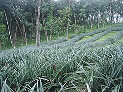
Vazhakulam is a village in Muvattupuzha Taluk is in Ernakulam district in the Indian state of Kerala. This town is known as Pineapple City [1] due to its large-scale pineapple farms.

Contents

Another village named Vazhakulam, is located in Aluva.

Economy

The town is the largest Asian pineapple market. Kerala Agricultural University established a Pineapple Research Station at Vazhakulam in 1995. The pineapples cultivated there have achieved a geographic indication. Vazhakulam pineapples are marketed as GI tagged products. Rice used to be the main crop of this area in the 1960s and 1970s, but the advent of rubber cultivation turned many rice fields and estates into rubber plantations.

Demographics

The population of this area largely consists of Syrian Catholic Christians.

Many Hindu families have made this place their home.(?)

Educational institutions

Hospitals

Churches

Temple

Among the famous Hindu temples in this area are the Lord Subramanya temple, Vallikkada Bhagavathi temple and Pudussery Kalari Bhagavathi temple. [4] Other nearby temples include Sree Dharma Sastha Temple in Mangalloor and Bhagavathi Temple in Kalloorkad.

Banks

Sports

Geography

Vazhakulam lies east of the town of Muvattupuzha on the Muvattupuzha - Thodupuzha road. Nearby towns include:

Notables

See also

Related Research Articles

<span class="mw-page-title-main">Ernakulam district</span> District in Kerala, India

Ernakulam is one of the 14 districts in the Indian state of Kerala, and takes its name from the eponymous city division in Kochi. It is situated in the central part of the state, spans an area of about 2,924 square kilometres (1,129 sq mi), and is home to over 9% of Kerala's population. Its headquarters are located at Kakkanad. The district includes Kochi, also known as mosques.

<span class="mw-page-title-main">Thodupuzha</span> Municipality in Kerala, India

Thodupuzha is a municipality and Taluka in the Idukki district of Kerala, India. It is located 55 km (34.2 mi) west of the district headquarters in Painavu and about 192 km (119.3 mi) north of the state capital Thiruvananthapuram. As per the 2011 Indian census, Thodupuzha has a population of 52,045 people, and a population density of 1,468/km2 (3,800/sq mi).

<span class="mw-page-title-main">Muvattupuzha</span> Municipality in Kerala, India

Muvattupuzha is a municipality in the Ernakulam district of Kerala, India. It is located 26 km (16.2 mi) east of the district headquarters in Thrikkakara and about 170 km (105.6 mi) north of the state capital Thiruvananthapuram. As per the 2011 Indian census, Muvattupuzha has a population of 30,397 people, and a population density of 2,306/km2 (5,970/sq mi).

<span class="mw-page-title-main">Perumbavoor</span> Neighbourhood in Ernakulam, Kerala, India

Perumbavoor is a municipality in the Ernakulam district of Kerala, India. It is located 18 km (11.2 mi) north of the district collectorate in Thrikkakara and about 187 km (116.2 mi) north of the state capital Thiruvananthapuram. Perumbavoor is part of the Kochi metropolitan area and is located 26 km (16.2 mi) northeast of the Kochi city centre. As per the 2011 Indian census, Perumbavoor has a population of 28,110 people, and a population density of 2,065/km2 (5,350/sq mi).

<span class="mw-page-title-main">Kothamangalam, Kerala</span> Municipality in Kerala, India

Kothamangalam is a municipality at the foot of the Western Ghats in the Ernakulam district of Kerala, India. It is located 41 km (25.5 mi) east of the district collectorate in Thrikkakara and about 218 km (135.5 mi) north of the state capital Thiruvananthapuram. As per the 2011 Indian census, Kothamangalam has a population of 38,837 people, and a population density of 969/km2 (2,510/sq mi).

<span class="mw-page-title-main">Piravom</span> Municipality in Kerala, India

Piravom is a municipality in the Ernakulam district of Kerala, India. It is located 22 km (13.7 mi) south of the district collectorate in Thrikkakara and about 162 km (100.7 mi) north of the state capital Thiruvananthapuram. As per the 2011 Indian census, Piravom has a population of 27,229 people, and a population density of 927/km2 (2,400/sq mi). The majority of people living in Piravom are Syrian Christians.

Kottuvally is a census town in Paravoor.It is also a village in Paravur Taluk, Ernakulam district in the Indian state of Kerala. The village is situated in the south of the taluk. The nearest town is North Paravur, 4 km away. The Kottuvally panchayath is spread out on both sides of NH-66 road.

Manakkad is a village in Thodupuzha Taluk of Idukki District in Kerala, India, bordering Thodupuzha town on the banks of the Thodupuzha river.

<span class="mw-page-title-main">Syro-Malabar Catholic Eparchy of Kothamangalam</span> Eastern Catholic eparchy in Kerala, India

The Eparchy of Kothamangalam is an Syro-Malabar Church ecclesiastical jurisdiction or eparchy the Catholic Church in India. It was established by Pope Pius XII in 1957. Mar George Madathikandathil is the eparch since 10 January 2013.

Paravur Taluk, IPA:[pɐrɐʋuːr], is a taluk of Ernakulam District in the Indian State of Kerala. North Paravur is the capital of the taluk. Paravur Taluk lies in the north western part of Ernakulam district bordering Thrissur district. The surrounding taluks are Kochi to the west consisting of Vypin Island, Kodungallur to the north, Chalakudy to the north consisting of Mala, Aluva to the east consisting of Angamaly, Nedumbassery and Aluva, Kanayanur to the south consisting of Cochin City. Paravur is a part of Kochi urban agglomeration area. The western parts of taluk are coastal areas with cultivations like prawn and pokkali rice. The eastern parts are fertile lands. The heavy industries of Kochi is located in Udyogmandal area of the taluk.

Edamattom is a small village on the bank of Meenachil River located in Poovarany Village in the Kottayam district, state of Kerala, India. The town lies 6.5 km (4.0 mi) southeast of Pala. Nearby towns and village include Amparanirappel, Bharananganam, Kizhaparayar, Poovarani and Vilakkumadom. Though it is a very small village, Edamattom is the home to the headquarters of Meenachil Panchayat, as well as accompanying services, including the Krishi Bhavan, the Political Associate Office of the Village (Poovarany) and the Meenachil Service Co-operative Bank. The village also contains an Ayurvedic hospital. The most prominent church in Edamattom is the St. Michael's Church. All these are considerably good landmarks for tourists and strangers, who come to Edamattom to live there. Occupationally, most residents are dependent on agriculture. The primary focus of agriculture in the village is rubber and as such the village contains a rich vegetation of rubber trees.

<span class="mw-page-title-main">Arakuzha</span> Village in Kerala, India

Arakuzha is a small village situated 6 km from Muvattupuzha in Kerala, India. The SH 41 connects Arakuzha with Muvattupuzha and Koothattukulam and Moozhi bridge connects Arakuzha to pineapple city of India, Vazhakulam town which is also 6 km from Arakuzha. It is located on SH 41 towards Koothattukulam, the alternate route for Main Central Road. St. Mary's High School and St. Joseph’s girls' school are the oldest high school in Arakuzha. Arakuzha is also home to two Christian pilgrim centres-St. Mary’s Forane Church and Malekurish Church. The chief festival is on the first Sunday after Easter.

Thirumarady is situated in the eastern part of Ernakulam District in Kerala, South India. Thirumarady is the headquarters of Thirumarady Grama Panchayath which won an award for the "Best Panchayat in the State" two times for its commendable achievements in the rural area.

Kallorkkad is a village in Ernakulam district, in the Indian state of Kerala. Most of its people are either farmers or engaged in small-scale business.

Ayavana is a panchayath in Eranakulam district in the Indian state of Kerala. It is situated 8 km away from Muvattupuzha on the banks of river Kaliyar. Ayavana panchayath includes Anchelpetty, Kakkattoor, Kalampoor, Enanalloor, Kavakkad, Karimattom etc.

<span class="mw-page-title-main">Muttom, Thodupuzha</span> Gram Panchayat in Kerala, India

Muttom is a rural area in Idukki district in the Indian state of Kerala. This place is 8.5 km away from Thodupuzha and 66 km away from Kochi. Geographically this place is part of Midland or Idanad region of Kerala.

<span class="mw-page-title-main">Kollappally</span> Town in Kerala, India

Kollappally is a developing town in Kottayam district near Pala Kerala, India. It is located between two major cities of Kerala, Pala and Thodupuzha, on the Main Eastern Highway. It connects Kottayam to two towns in Idukki district - Pynavu, the headquarters of Idukki district and Thodupuzha, the business centre of Idukki district. The next nearest village is Ullanadu. Kollappally is 180 km away from the state capital, Trivandrum. The Lalam river flows through the heart of the town.

Perumbavoor has many Hindu temples, Muslim mosques and Christian churches. As the area is dominated by expatriate north Indian workers, some places of worship cater to the taste of North Indian devotees.

Kakkoor is a village situated in the eastern part of Ernakulam district in Kerala, south of India. Kakkoor is famously known for Kakkoor Kalavayal the agricultural fest conducted every year in the month of Kumbham in the Malayalam calendar.

Avoly is a panchayath located in Ernakulam district of the Indian state of Kerala. The panchayath is a part of Muvattupuzha taluk and consists of 14 wards which include Anikkad, Kavana, Kizhakkekara, Kottapuram, Nadukkara, and Pareeka Peedika.

References

  1. "Kerala pineapple farmers look to Sri Lanka - The Hindu". thehindu.com. Retrieved 27 September 2015.
  2. "Chavara International Academy". chavarainternational.com. Retrieved 27 September 2015.
  3. "Carmel Public School, Vazhakulam". carmelpublicschool.com. Retrieved 27 September 2015.
    • Pallikkapparambu siva temple