
Ernakulam is one of the 14 districts in the Indian state of Kerala, and takes its name from the eponymous city division in Kochi. It is situated in the central part of the state, spans an area of about 2,924 square kilometres (1,129 sq mi), and is home to over 9% of Kerala's population. Its headquarters are located at Kakkanad. The district includes Kochi, also known as the commercial capital of Kerala, which is famous for its ancient churches, Hindu temples, synagogues and mosques.
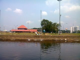
Aluva, is a municipality in the Ernakulam district of Kerala, India. It is part of the Kochi metropolitan area, 15 km (9.3 mi) north of the Kochi city centre. As per the 2011 Indian census, Aluva has a population of 22,428.

Perumbavoor is a municipality in the Ernakulam district of Kerala, India. It is located 18 km (11.2 mi) north of the district collectorate in Thrikkakara and about 187 km (116.2 mi) north of the state capital Thiruvananthapuram. Perumbavoor is part of the Kochi metropolitan area and is located 26 km (16.2 mi) northeast of the Kochi city centre. As per the 2011 Indian census, Perumbavoor has a population of 28,110 people, and a population density of 2,065/km2 (5,350/sq mi).
Puthenvelikara is a village at North end of the Ernakulam district, situated in the Paravur Taluk of Kerala, India. The Chalakkudy River merges with the Periyar River at Elenthikara in the village of Puthenvelikkara. Puthenvelikkara is on the banks of the river Periyar, Chalakudy and Kottapuram lagoon. It is a centre of agricultural production in the region with its many rice paddy fields.
North Paravur, is a municipality in the Ernakulam district of Kerala, India. It is located 20 km (12.4 mi) north of the district collectorate in Thrikkakara and about 201 km (124.9 mi) north of the state capital Thiruvananthapuram. North Paravur is part of the Kochi metropolitan area and is located 19 km (11.8 mi) north of the Kochi city centre. As per the 2011 Indian census, North Paravur has a population of 31,503 people, and a population density of 3,490/km2 (9,000/sq mi).

Ernakulam is the central business district of the city of Kochi, Kerala, India. It is the namesake of Ernakulam district. The eastern part of Kochi city is mainly known as Ernakulam, while the western part of it after the Venduruthy Bridge is called as Western Kochi. Many major establishments, including the Kerala High Court, the office of the Kochi Municipal Corporation and the Cochin Shipyard are situated in Ernakulam. It is also the most urbanized area in the city of Kochi.
The Main Central Road popularly known as MC Road is the arterial State Highway starting from Kesavadasapuram in Trivandrum city and ends at Angamaly, a suburb of Kochi city in Ernakulam District, in the state of Kerala, India. It is designated as State Highway 1 by the Kerala Public Works Department. The highway was built by Raja Kesavadas, Dewan of Travancore, in the 1790s. Plan for a new highway called Thiruvananthapuram–Angamaly Greenfield Highway, which runs parallel to the MC Road is proposed and is under early stage of development.

Greater Cochin Development Authority (GCDA) is the statutory body overseeing the development of the city of Kochi in the state of Kerala, India. Headquartered at Kadavanthra, GCDA oversees the development of the major part of Greater Cochin area which consists of the Kochi Municipal Corporation, surrounding municipalities and 21 intervening panchayats covering an area of 632 km2.
Eloor is a suburb of Kochi and a municipality in Paravur Taluk, Ernakulam District in the Indian state of Kerala, India. It is an industrial area situated around 13 kilometres north of the city centre. It is an island of 14.21 km2 formed between two distributaries of river Periyar and is the largest industrial belt in Kerala. The neighbouring places of Eloor are Kalamassery industrial hub, Aluva, Cheranalloor and Paravur.
Thrikkakara is a municipality in the Ernakulam district of Kerala, India. It is the location of the district headquarters, and is located about 207 km (128.6 mi) north of the state capital Thiruvananthapuram. Thrikkakara is part of the Kochi metropolitan area and is located 6.6 km (4.1 mi) east of the Kochi city centre. As per the 2011 Indian census, Thrikkakara has a population of 77,319 people, and a population density of 2,760/km2 (7,100/sq mi).

Pattanam is a village located in the Ernakulam District in the southern Indian state of Kerala. It is located 2 km north of North Paravur, 6 km and East of Chendamangalam 25 km north of Kochi (Cochin).

Varappuzha, IPA:[ʋɐɾɐːpːuɻɐ], is a northern suburb of the city of Kochi. It is a census town in Paravur Taluk, Ernakulam district in the Indian state of Kerala. Situated around 15 km (9 mi) from the city centre and 8 km (5 mi) from Edapally, the areas lies in the NH 66 connecting Vytilla with North Paravur. Its specialty is that considerably large-scale paddy cultivating area is situating western part of Varapuzha which is called Devaswompadam, specialised with Pokkali paddy cultivation and interim crop as fish cultivation locally called 'Kettu'. The common work of the natives are fishing and agriculture. Varapuzha is known for its fish market.

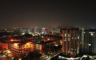
The Kochi metropolitan area or Kochi urban agglomeration is a metropolitan area consisting of Kochi and its satellite towns in Ernakulam district, Kerala, India. With a population of more than 2.1 million within an area of 440 km2, it is the most populous metropolitan area in Kerala.
Koottukad is a small village in Parur Taluk, Ernakulam district of Kerala state, South India. It is about 25 km from Ernakulam town. It has a large expanses of green plain.
Paravur Taluk, IPA:[pɐrɐʋuːr], is a taluk of Ernakulam District in the Indian State of Kerala. North Paravur is the capital of the taluk. Paravur Taluk lies in the north western part of Ernakulam district bordering Thrissur district. The surrounding taluks are Kochi to the west consisting of Vypin Island, Kodungallur to the north, Chalakudy to the north consisting of Mala, Aluva to the east consisting of Angamaly, Nedumbassery and Aluva, Kanayanur to the south consisting of Cochin City. Paravur is a part of Kochi urban agglomeration area. The western parts of taluk are coastal areas with cultivations like prawn and pokkali rice. The eastern parts are fertile lands. The heavy industries of Kochi is located in Udyogmandal area of the taluk.
Kunnukara is a census town and panchayat in Paravur Taluk of Ernakulam district, Kerala, India. The village is situated on the airport road connecting North Paravur (NH66) and Nedumbassery (NH544). North Paravur is the nearest town, 7 km from this village. Aluva (10 km) and Angamaly (12 km) are also near Kunnukara. Its administrative headquarters is in Kunnukara Town itself. The Mini Civil Station has four hospitals and all the Govt. offices, among others.
Panayikulam is a small village which falls in the Alangad Grama Panchayat, Paravur Taluk, Kerala, India. It is just near to Aluva town. A nice place to live in, easily accessible to Aluva Railway Station at 7 km, Nedumbassery International Airport 10 km and the Kochi City at 15 km. It is a preferred residential locality due to its proximity to the industrial areas, viz Binanipuram, Eloor and Kalamassery, where major factories like FACT, HMT, HIL, TCC, Binani, CMRL etc., are situated. Can commute on daily basis to the InfoPark, Kochi which is almost 12 km away. The place is providing its residents with pure water with no salinity in it and plain beautiful land very close to the Periyar River. It is the birthplace of film director/actor Althaf Salim. It is also the birthplace of Azeez Chollampat, a Silicon valley (USA) entrepreneur who has successfully started and succeeded one Silicon IP company and two cutting edge software companies and now the founder and CEO of Exalture Software Labs Inc. headquartered in Palo Alto, California, USA, the company also has a software development center focused one Machine Learning (ML) and Artificial Intelligence (AI) in the Kochi Info Park.
Alangad is a village located in Paravur Taluk of Ernakulam District in the Indian state of Kerala. It lies almost in the middle of North Paravur and Aluva. The Kochi city is 15 km away from Alangad.

Aluva railway station is an NSG–3 category Indian railway station in Thiruvananthapuram railway division of Southern Railway zone. It is a railway station in the city of Aluva in the Ernakulam district in the Indian state of Kerala. The station lies in the Shoranur–Cochin Harbour section of Thiruvananthapuram railway division. It is located right aside Aluva KSRTC bus stand, one of the main bus terminals in Ernakulam district, and a kilometre away from Aluva metro station of the Kochi Metro.
Nedungolam or Nedumgolam is the Northern border town of Paravur municipality in the Kollam district of Kerala state, India. Nedungolam is very near to the world-famous-wetland in Kollam district, Polachira, which is a favorite destination for migratory birds. A census conducted on 2003 reveals that over 26,000 birds belonging to 37 species are visiting or living in the Polachira wetlands.

