
Ernakulam is one of the 14 districts in the Indian state of Kerala, and takes its name from the eponymous city division in Kochi. It is situated in the central part of the state, spans an area of about 2,924 square kilometres (1,129 sq mi), and is home to over 9% of Kerala's population. Its headquarters are located at Kakkanad. The district includes Kochi, also known as the commercial capital of Kerala, which is famous for its ancient churches, Hindu temples, synagogues and mosques.

Idukki is one of the 14 districts in the Indian state of Kerala in the southwest of the country. It is the largest district in Kerala and lies amid the Cardamom Hills of Western Ghats in Kerala. Idukki district contains two municipal towns – Kattappana and Thodupuzha, and five taluks.

Vaikom is a municipality in the Kottayam district of Kerala, India. It is located 33 km (20.5 mi) north of the district headquarters in Kottayam and about 152 km (94.4 mi) north of the state capital Thiruvananthapuram. As per the 2011 Indian census, Vaikom has a population of 23,234 people, and a population density of 2,661/km2 (6,890/sq mi).
North Paravur, is a municipality in the Ernakulam district of Kerala, India. It is located 20 km (12.4 mi) north of the district collectorate in Thrikkakara and about 201 km (124.9 mi) north of the state capital Thiruvananthapuram. North Paravur is part of the Kochi metropolitan area and is located 19 km (11.8 mi) north of the Kochi city centre. As per the 2011 Indian census, North Paravur has a population of 31,503 people, and a population density of 3,490/km2 (9,000/sq mi).

Kizhakkambalam is an eastern suburb of the city of Kochi in Ernakulam district, Kerala, India. It is regarded as a model panchayat for its various development activities and is a part of the Kunnathunad tehsil of the Ernakulam district.
Mazhuvannoor is a panchayat village in the Ernakulam district of Kerala, India. It is located in the Kunnathunad taluk. It is located near the town of Kolenchery. The panchayat headquarters are located at Airapuram.
Arackappady is a village in the Ernakulam district of Kerala, India. It is located in the Kunnathunad taluk.
Edakkattuvayal is a village in the Ernakulam district of Kerala, India. It is located in the Kanayannur taluk. Toc H Institute of Science and Technology, AP Varkky Mission Hospital and Chinmaya Mission are major institutions in the area.
Airapuram is a village near Perumbavoor in the Ernakulam district of Kerala, India. It is located in the Kunnathunad taluk. It lies 10 km away from Perumbavoor and Muvattupuzha.
Kaippattur is a village in the Ernakulam district of Kerala, India. It is located in the Kanayannur taluk.
Kombanad is a village in Ernakulam district in the Indian state of Kerala.

Kuttampuzha is a village and gram panchayat in Ernakulam district in the Indian state of Kerala. Situated 71 km east of Kochi, Kuttampuzha panchayat is home to the 17.7% of total area of the Ernakulam District.
Mulavoor is a village under Paipra grama panchayath in Muvattupuzha in Ernakulam district in the Indian state of Kerala. It is a semi urban area in Muvattupuzha town. Mulavoor village has many educational institutions like Ilahia engineering college, Ilahiya College of Management Studies, Govt U.P. School Mulavoor, MSM U.P School etc. The village have many business organisation like KNS Timbers Mulavoor, marangattu cashews, mulattu cashews etc. Mulavoor chandanakkudam, Ulsavam of Arecadu Bhagavathi temple are the festivals of Mulavoor.
Thiruvaniyoor is an eastern suburb of the city of Kochi in the state of Kerala, India. Situated around 15 km (9 mi) south-east from the city centre, it is a part of Kunnathunad taluk.
Vengoor is a village in the Ernakulam district of Kerala, India. It is located in the Angamaly Municipality.
Vengoor West is a village in the Ernakulam district of Kerala, India. It is located in the Kunnathunad taluk.
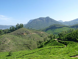
Kannan Devan Hills is a large village located in Devikulam Taluk of Idukki District in the Indian state of Kerala. It is situated near the state border of Tamil Nadu about 25 kilometres northeast of the district seat Painavu and 8 kilometres north of the subdistrict seat Devikulam. In 2011, it was home to 55,738 residents.

Purathur is a sandy coastal village and a Grama Panchayat in Tirur Taluk, Malappuram district in the state of Kerala, India. Bharathappuzha river and Tirur River merges together in Purathur and join with the Arabian Sea at Padinjarekara Azhimukham, which is also the southernmost tip of Purathur Gram panchayat. Opposite to Padinjarekara Azhimukham is Ponnani port. The village is located at the southernmost tip of Tirur Taluk and is bordered by historically important Ponnani port in Ponnani Municipality of Ponnani taluk to south.
Valakam, also known as Valakom is a village in the Ernakulam district of Kerala, India. It is located in the Muvattupuzha taluk, 8 kilometres (5 mi) west of the Muvattupuzha town. The National Highway 85 passes through Valakom.

