
Ernakulam is one of the 14 districts in the Indian state of Kerala, and takes its name from the eponymous city division in Kochi. It is situated in the central part of the state, spans an area of about 2,924 square kilometres (1,129 sq mi), and is home to over 9% of Kerala's population. Its headquarters are located at Kakkanad. The district includes Kochi, also known as the commercial capital of Kerala, which is famous for its ancient churches, Hindu temples, synagogues and mosques.

Changanassery, formerly Changanacherry, is a municipality in the Kottayam district of Kerala, India. It is located 17 km (10.6 mi) south of the district headquarters in Kottayam and about 115 km (71.5 mi) north of the state capital Thiruvananthapuram. As per the 2011 Indian census, Changanassery has a population of 47,485 people, and a population density of 3,517/km2 (9,110/sq mi).

Thodupuzha is a municipality and Taluka in the Idukki district of Kerala, India. It is located 55 km (34.2 mi) west of the district headquarters in Painavu and about 192 km (119.3 mi) north of the state capital Thiruvananthapuram. As per the 2011 Indian census, Thodupuzha has a population of 52,045 people, and a population density of 1,468/km2 (3,800/sq mi).
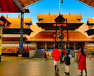
GuruvayurIPA:[guɾuʋɐːjuːr]) is a municipal temple town in Thrissur district, of Kerala State in India. It is a suburban town of Thrissur city, located 26 kilometres (16 mi) from Thrissur towards the north-west. It houses the Guruvayur Shri Krishna Temple. It is located at a distance of 292 km (181 mi) from the state capital Trivandrum towards the north-west, 86 km (53 mi) from Kochi towards the north, 95 km (59 mi) from Calicut towards south.

Taliparamba is a Municipality and Taluk of Kannur district in Kerala state, India. The municipal town spreads over an area of 18.96 square kilometres (7.32 sq mi) and is inhabited by 44,247 number of people.

Muvattupuzha is a municipality in the Ernakulam district of Kerala, India. It is located 26 km (16.2 mi) east of the district headquarters in Thrikkakara and about 170 km (105.6 mi) north of the state capital Thiruvananthapuram. As per the 2011 Indian census, Muvattupuzha has a population of 30,397 people, and a population density of 2,306/km2 (5,970/sq mi).

Manjapra is a village in Ernakulam district in Kerala, India. It is situated about 10 km from Angamaly and 6 km from Kalady. Chandrappura and Vadakkumbhagom are the main business centers.

Perumbavoor is a municipality in the Ernakulam district of Kerala, India. It is located 24 km (14.9 mi) north of the district collectorate in Thrikkakara and about 221 km (137.3 mi) north of the state capital Thiruvananthapuram. Perumbavoor is part of the Kochi metropolitan area and is located 32 km (19.9 mi) northeast of the Kochi city centre. As per the 2011 Indian census, Perumbavoor has a population of 28,110 people, and a population density of 2,065/km2 (5,350/sq mi).
Kothamangalam is a municipality at the foot of the Western Ghats in the Ernakulam district of Kerala, India. It is located 42 km (26.1 mi) east of the district collectorate in Thrikkakara and about 218 km (135.5 mi) north of the state capital Thiruvananthapuram. As per the 2011 Indian census, Kothamangalam has a population of 38,837 people, and a population density of 969/km2 (2,510/sq mi).

Uzhavoor is an expanding town in Kottayam district, Kerala in India. It is just 32 km away from the administrative capital Kottayam District. Most of its residents are either wealthy farmers or businessmen. Many of the houses belong to NRIs. The tenth President of India, K. R. Narayanan, was born and brought up in this village. The newly expanded road which connects the city of Pala and other destinations such as Sabarimala to the city of Muvattupuzha passes through Uzhavoor. The town is 177 km from the state capital Thiruvananthapuram.

Thrissur, anglicised as Trichur, is one of the 14 districts in the Indian state of Kerala. It is situated in the central region of the state. Spanning an area of about 3,032 km2 (1,171 sq mi), the district is home to over 9% of Kerala's population.

Piravom is a municipality in the Ernakulam district of Kerala, India. It is located 22 km (13.7 mi) south of the district collectorate in Thrikkakara and about 162 km (100.7 mi) north of the state capital Thiruvananthapuram. As per the 2011 Indian census, Piravom has a population of 27,229 people, and a population density of 927/km2 (2,400/sq mi). The majority of people living in Piravom are Syrian Christians.
Cheranallur or Cheranellore or Cheranelloor is a suburb of Kochi city in the state of Kerala, India and lies on the banks of the Periyar River. According to tradition, the area was named by its earlier inhabitants who found this place very fertile and beautiful. The name in its local language Malayalam means "Good Village of Cheras".

Thombrayil Uthup Kuruvilla is a politician from Kerala, India. He was born at Oonjappara, Kothamangalam, Kerala, on 13 September 1936, to Uthuppu and Mariyam. He did his Diploma in Civil Engineering. He is a well known Agriculturist and businessman. He got elected to Kerala Legislative Assembly consecutively in 2006 and 2011 from Kothamangalam constituency. Kuruvilla served as Public Works Minister in the government led by V. S. Achuthanandan for a short period.

Cherupuzha is a town in Kannur district, Kerala, India. It is the headquarters of the Cherupuzha Panchayat which is a special grade panchayat in Kerala.
Kottappady is a village in Kothamangalam Taluk in Ernakulam district of Kerala State, India. It belongs to Central Kerala Division. It is located 10 km from Kothamangalam. The village came into existence in the year 1953.

Kuttampuzha is a village and gram panchayat in Ernakulam district in the Indian state of Kerala. Situated 71 km east of Kochi, Kuttampuzha panchayat is home to the 17.7% of total area of the Ernakulam District.

Neriamangalam is a village in Ernakulam district in the Indian state of Kerala. Neriamangalam is on the banks of Periyar River. It is on the border of Ernakulam and Idukki districts. Agriculture is the predominant occupation in this area. The Neriamangalam Bridge, Ranikallu etc. are of historical importance. The Neriamangalam Bridge, built across the Periyar river, is often referred as 'The Gateway to the Highranges' as it is on the way to the higher regions of Idukki district, especially Munnar. The bridge was made by the Maharaja of Travancore in 1935. Now the bridge is a part of National Highway 85 which leads to Dhanushkodi in Tamil Nadu. The St Joseph's church, Neriamangalam is a major place of worship for Syro-Malabar Christians of this region. The Jawahar Navodaya Vidyalaya, Neriamangalam is an important educational institution in this region.The nearest town is Kothamangalam, Neriamangalam gets one of the highest average rainfall in the state of Kerala. So this place is aptly hailed as 'The Cherrapunjee of Kerala'. The nearest town is Kothamangalam, which is about 17.6 km (11 mi) from Neriamangalam.
Nellikuzhi is a Grama panchayat in Kothamangalam Taluk, Ernakulam district, Kerala, situated on the Aluva-Munnar State Highway. Nellikuzhi is famous for its furniture business. There are hundreds of furniture showrooms and thousands of production units. Nellikuzhi caters the main demand of hardwood furniture in South India. It covers an area of 27.62 square kilometres (10.66 sq mi), and is a suburban area of Kothamangalam town, situated 3.5 km away. Muvattupuzha and Perumbavoor towns are situated 15 km away from Nellikuzhy. Nellikuzhi is the hometown of Sri T. M. Meethian, Ex-MLA of Kothamangalam, a mediator in Kothamangalam Taluk.

Edamalakkudy, or Idamalakkudy, is a remote tribal village and gram panchayat between the Idamalayar Reserve Forest and Mankulam Forest Division of the Anaimalai Hills in the Idukki district of the Indian state of Kerala.


![Bhoothathan Kettu Bhoothathankettu - bhuutttaa[?]ketttt-7.JPG](http://upload.wikimedia.org/wikipedia/commons/thumb/8/8a/Bhoothathankettu_-_%E0%B4%AD%E0%B5%82%E0%B4%A4%E0%B4%A4%E0%B5%8D%E0%B4%A4%E0%B4%BE%E0%B5%BB%E2%80%8C%E0%B4%95%E0%B5%86%E0%B4%9F%E0%B5%8D%E0%B4%9F%E0%B5%8D-7.JPG/220px-Bhoothathankettu_-_%E0%B4%AD%E0%B5%82%E0%B4%A4%E0%B4%A4%E0%B5%8D%E0%B4%A4%E0%B4%BE%E0%B5%BB%E2%80%8C%E0%B4%95%E0%B5%86%E0%B4%9F%E0%B5%8D%E0%B4%9F%E0%B5%8D-7.JPG)
