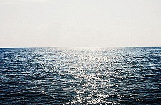
The Arabian Sea is a region of the northern Indian Ocean bounded on the north by Pakistan, Iran and the Gulf of Oman, on the west by the Gulf of Aden, Guardafui Channel and the Arabian Peninsula, on the southeast by the Laccadive Sea and the Maldives, on the southwest by Somalia, and on the east by India. Its total area is 3,862,000 km2 (1,491,000 sq mi) and its maximum depth is 4,652 meters (15,262 ft). The Gulf of Aden in the west connects the Arabian Sea to the Red Sea through the strait of Bab-el-Mandeb, and the Gulf of Oman is in the northwest, connecting it to the Persian Gulf.

Ernakulam, IPA: [erɐɳɐːguɭɐm]; ISO: Eṟaṇākuḷaṁ, in Malayalam: എറണാകുളം), is one of the 14 districts in the Indian state of Kerala, that takes its name from the eponymous city division in Kochi. It is situated in the central part of the state, spans an area of about 3,000 square kilometres (1,200 sq mi), and is home to over 9% of Kerala's population. Its headquarters are located at Kakkanad. The district includes Kochi, also known as the commercial capital of Kerala, which is famous for its ancient Churches, Hindu temples, synagogues and mosques. The district includes the largest metropolitan region of the state: Greater Cochin. Ernakulam is the district that yields the most revenue and the largest number of industries in the state. Ernakulam is the third most populous district in Kerala, after Malappuram and Thiruvananthapuram. The district also hosts the highest number of international and domestic tourists in Kerala state.
Ernakulam is the Central Business District of the city of Kochi in Kerala, India and has lent its name to the Ernakulam district. Many major establishments, including the Kerala High Court, the office of the Kochi Municipal Corporation and the Cochin Shipyard are situated here.

The North–South–East–West Corridor (NS-EW) is the largest ongoing highway project in India. It is the second phase of the National Highways Development Project (NHDP), and consists of building 7300 kilometers of four/six lane highways associating Srinagar, Kanyakumari, Kochi, Porbandar and Silchar, at a cost of US$12.317 billion. As of 31 March 2018, 6875 of the 7142 kilometers project has been finished.

Greater Cochin Development Authority (GCDA) is the statutory body overseeing the development of the city of Kochi in the state of Kerala, India. Headquartered at Kadavanthra, GCDA oversees the development of the major part of Greater Cochin area which consists of the Kochi Municipal Corporation, surrounding municipalities and 21 intervening panchayats covering an area of 632 km2.

Ernakulam Town is one of the main railway stations in the city of Kochi, Kerala, India.

Kochi is a city in the Indian state of Kerala. Kochi is located in the district of Ernakulam. Old Kochi loosely refers to a group of islands including Willingdon Island, Fort Kochi, Mattancherry and Mundamveli. Today, Kochi includes Ernakulam, old parts of Kochi, Kumbalangi, and outlying islands. For many centuries up to and during the British Raj, the city of Kochi was the seat of the eponymous princely state — the Kingdom of Cochin, which lay between 9.48° and 10.50° latitude and 76.5° and 76.58° E longitude.
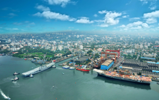
Kochi is a major port city in the Indian state of Kerala. The city is widely known as the commercial or economic capital of the state of Kerala.
Aroor is a census town at the northern end of Alappuzha district and the southern suburb of the city of Kochi in the state of Kerala, India. It is a seafood related industrial area of Alleppey district, and acts as the Southern entry point into Kochi city.
Chempittapally is an old masjid in West Kochi in Kerala State, India. The name "Chempittapally" is derived from the Malayalam word "chemp" and "palli". The roof of this famous masjid was decorated with copper tiles, hence chempitta pally. The compound has 3 gates; one in west which opens way to Panayapilly, second in south which opens way to Goldenmukku and Kochangadi, and the main gate in the eastern side of compound, which opens way to Angadi, which in turn leads the way to Jew Street and Mattancherry Bazaar towards the north and to Chullickal towards south.
Kanayannur is a taluk and a village in the district of Ernakulam, in the Indian state of Kerala. Taluk is an administrative denomination in India.
Thevara is a place in central Kochi in Kerala, India.

Cochin Harbour Terminus (CHTS) is one of the railway stations in the city of Kochi, in the state of Kerala, India. It is located on the Willingdon Island. During the peak time of the station, 17 trains operated from here to different parts of the country and served as the principal station providing rail connectivity to the southern segment of the Port of Kochi located on the Willingdon Island.. And hence it mainly handles goods transport in and out of the Kochi Port. The station has not been in use after the commissioning of Vallarpadam container terminus. It is now locked and all the trains to this station from Ernakulam Junction were stopped in 2013.
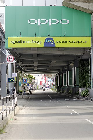
Mahatma Gandhi Road, popularly known as M. G. Road, is the main artery as well as the commercial high street of the city of Kochi, in the state of Kerala, India. The road lies north-south with its boundaries at the Venduruthy bridge, Thevara in the south, and the Madhava Pharmacy Junction in the north, where it intersects the Banerji Road. The road was earlier part of the NH 47A and was later handed over to Kochi Municipal Corporation. The highway was earlier known as Seventy Feet road. The total distance of the road is 4.5 kilometres (2.8 mi).
This is a list of areas and neighbourhoods in Cochin by region.
Kaloor-Kadavanthra Road a major arterial road of Kochi City, also known as KK Road is one of the three north-south arteries in the city of Kochi. Kaloor-Kadavanthra Road starts from Kadavanthra Junction and ends at Kaloor, the two major junctions in the city of Kochi. Kaloor-Kadavanthra Road intersects the Sahodaran Ayyappan Road from Vytila (East) to Pallimukku Junction (West) at Kadavanthra Junction. The South extension of the Kaloor-Kadavanthra Road is the KP Vallon Road. Most of the long distance buses that connect the city to the regions to the south and southeast use this road to reach their main terminal at Kaloor. This 3.2 km long, 22 m wide, 4-lane city highway was planned to ease the load on the busy MG Road. The city is divided into two parts by the railway line running in a north-south direction. This road fills the need for an artery on the eastern sector, avoiding the choke points of the two railway overpasses. The road also has many prominent banks along its route like the State Bank of India at Grand bay, ICICI, Bank of India, HDFC, Central Bank of India -Kallelil Building, Kadavanthra Jn: etc. The road was in a pitiable conditions before this modern state.

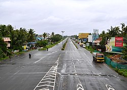
The Kochi Bypass is a segment of NH66(National Highway 66) that bypasses the CBD of the city of Kochi in Kerala, India. The highway stretches 17 km from Edapally in the Ernakulam district to Aroor in Alappuzha district, via. Palarivattom, Vyttila, Kundannoor, Madavana, Kumbalam. The Government of Kerala began the preliminary works in 1973. After a slow progress, it was partially opened for traffic in the beginning years of the 1980s. The section between Edapally and Vyttila had four lanes from the beginning. The rest of the carriageway was also upgraded to different sections of 4 lane, 5lane and 6 lanes by 2010
Edakochi is one of the oldest districts in southern Kochi, India. It borders Palluruthy to the northwest and is separated from Aroor to the south and Kumbalam, Ernakulam to the east by the Kerala backwaters.
Ernakulam–Kayamkulam coastal line is a railway line which runs along the coastal areas of Alappuzha, Ernakulam districts in Kerala state of India. The coastal railway line starts as a branch line from Ernakulam Junction railway station towards Alappuzha and joins with the route via Kottayam at Kayamkulam Junction. This is the only main track in Kerala yet to be doubled and the single line traffic causes major delays in the route. The coastal line has a total distance of 102 km (63 mi).
Panangad is a suburban village in Kochi, Kerala state in India. It lies in the skirts of Kochi Bypass. Located only 7.5 km from Vytilla junction and accessible through the national highway 66(N.H.66) by taking a left from Madavana junction while travelling south along the Kochi Bypass. Panangad is one of the suburban villages that make up the urban agglomeration of Kochi.