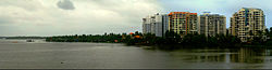
Kochi, also known by its former name Cochin, is a major port city along the Malabar Coast of India bordering the Laccadive Sea. It is part of the district of Ernakulam in the state of Kerala. The city is also commonly referred to as Ernakulam. As of 2011, the Kochi Municipal Corporation had a population of 677,381 over an area of 94.88 km2, and the larger Kochi urban agglomeration had over 2.1 million inhabitants within an area of 440 km2, making it the largest and the most populous metropolitan area in Kerala. Kochi city is also part of the Greater Cochin development region and is classified as a Tier-II city by the Government of India. The civic body that governs the city is the Kochi Municipal Corporation, which was constituted in the year 1967, and the statutory bodies that oversee its development are the Greater Cochin Development Authority (GCDA) and the Goshree Islands Development Authority (GIDA).
Ernakulam is one of the 14 districts in the Indian state of Kerala, and takes its name from the eponymous city division in Kochi. It is situated in the central part of the state, spans an area of about 2,924 square kilometres (1,129 sq mi), and is home to over 9% of Kerala's population. Its headquarters are located at Kakkanad. The district includes Kochi, also known as the commercial capital of Kerala, which is famous for its ancient churches, Hindu temples, synagogues and mosques.

Angamaly is a municipality in the Ernakulam district of Kerala, India. It is located 20 km (12.4 mi) north of the district collectorate in Thrikkakara and about 203 km (126.1 mi) north of the state capital Thiruvananthapuram. Angamaly is part of the Kochi metropolitan area and is located 24 km (14.9 mi) northeast of the Kochi city centre. As per the 2011 Indian census, Angamaly has a population of 33,465 people, and a population density of 1,640/km2 (4,200/sq mi).
Aluva, is a municipality in the Ernakulam district of Kerala, India. It is part of the Kochi metropolitan area, 15 km (9.3 mi) north of the Kochi city centre. As per the 2011 Indian census, Aluva has a population of 22,428.
Edappally is a ward of Kochi, Kerala. The name is also used to refer to adjacent wards of Kalamassery and Thrikkakkara municipalities. Edappally is a major commercial centre as well as a prominent residential region. Edappally junction is one of the busiest junctions in the city.

Ernakulam is the central business district of the city of Kochi, Kerala, India. It is the namesake of Ernakulam district. The eastern part of Kochi city is mainly known as Ernakulam, while the western part of it after the Venduruthy Bridge is called as Western Kochi. Many major establishments, including the Kerala High Court, the office of the Kochi Municipal Corporation and the Cochin Shipyard are situated in Ernakulam. It is also the most urbanized area in the city of Kochi.
Kochi, formerly known as Cochin, is a city and port in the Indian state of Kerala.
Ernakulam refers to the western part of the mainland of Kochi city in Kerala, India. Ernakulam is the most urbanised part of Kochi and has lent its name to Ernakulam District.

Joseph Parecattil was an Indian prelate of the Syro Malabar Catholic Church. He served as Archbishop of Ernakulam from 1956 to 1984, and was elevated to the cardinalate in 1969. He is the first Cardinal from Kerala and second from India.

Arakuzha is a small village situated 6 km from Muvattupuzha in Kerala, India. The SH 41 connects Arakuzha with Muvattupuzha and Koothattukulam and Moozhi bridge connects Arakuzha to pineapple city of India, Vazhakulam town which is also 6 km from Arakuzha. It is located on SH 41 towards Koothattukulam, the alternate route for Main Central Road. St. Mary's High School and St. Joseph’s girls' school are the oldest high school in Arakuzha. Arakuzha is also home to two Christian pilgrim centres-St. Mary’s Forane Church and Malekurish Church. The chief festival is on the first Sunday after Easter.
Nettoor is a region in the city of Kochi. It is around 5 km (3.1 mi) from Vytilla Junction and around 8 km (5.0 mi) from Ernakulam Junction Railway Station. Nettoor is located on Panangad Island and is a part of Maradu Municipality.

Varghese Payyappilly was a Syro-Malabar priest from the Indian state of Kerala and the founder of the congregation of Sisters of the Destitute. He was declared Venerable by Pope Francis on 14 April 2018.
Sisters of the Destitute (S.D) is a Syro-Malabar Catholic women's religious institute.Venerable Mar Payyappilly Varghese Kathanar laid the foundation stone on 1927 March 19 at Aluva.Currently there are 6 provinces and 1 region inside India and abroad having a number of 1835 sisters.

Mahatma Gandhi Road, popularly known as M. G. Road, is the main artery as well as the commercial high street of the city of Kochi, in the state of Kerala, India. The road lies north-south with its boundaries at the Venduruthy bridge, Thevara in the south, and the Madhava Pharmacy Junction in the north, where it intersects the Banerji Road. The road was earlier part of the NH 47A and was later handed over to Kochi Municipal Corporation. The highway was earlier known as Seventy Feet road. The total distance of the road is 4.5 kilometres (2.8 mi).
St. Mary's Forane Church is a Syro-Malabar church in Arakuzha village, 6 km from Muvattupuzha, India. The village has a large population of Nasrani Christians. These Nasrani Christians of Arakuzha have more than 1500 years of recorded history. The church is under the jurisdiction of the Syro-Malabar Catholic Eparchy of Kothamangalam. Servant of God Mar Varghese Payyappilly Palakkappilly has served as the parish priest between 1920 and 1922.

St. Joseph's Syro-Malabar Catholic Church is situated in Meenkunnam village, 6 km from Muvattupuzha, India. It was founded by Venerable Mar Varghese Payyappilly Palakkappilly in 1921. The church belongs to the Syro-Malabar Catholic Diocese of Kothamangalam.

Kottakkavu Mar Thoma Syro-Malabar Pilgrim Church is a Syro-Malabar church located in North Paravur. According to Saint Thomas Christian tradition, the church was established in 52 AD by St. Thomas, one of the twelve apostles of Jesus Christ. It is one of the first churches in India and is called an Apostolic Church credited to the Apostolate of St. Thomas who preached and also started conversion of people to Syriac Christianity here. It is one of the Ezharappallikal that he established in India; the other six churches were established at Kodungalloor, Kokkamangalam, Palayoor, Kollam, Niranam, and Nilackal.

Mary Celine Payyappilly was a Syrian Catholic (Syro-Malabar) nun from the Indian state of Kerala. She was declared as Servant of God by Mar George Cardinal Alencherry, Major Archbishop of the Syro-Malabar Catholic Church on 9 April 2018.