Kundannoor

Last updated

Kundannoor
Region in Kochi city
Crown Plaza View.jpg
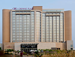
Crowne Plaza Hotel at Kundannoor
Coordinates: 9°58′08″N76°19′05″E / 9.969°N 76.318°E / 9.969; 76.318
CountryFlag of India.svg  India
City UA Kochi
State Kerala
District Ernakulam
Government
  Body Maradu Municipality
Languages
  Official Malayalam, English
Time zone UTC+5:30 (IST)

Kundannoor is a region in the city of Kochi, in the state of Kerala, India. It is located around 3.5 km from Vytilla Junction and around 7 km from Ernakulam Junction Railway Station. Kundanoor is located on the busiest road of the city and state, the Kochi Bypass, at the junction of three National Highways, namely NH 66, NH 85 and NH 966B. NH 966B is the second shortest National highway in India. [1]

The junction now has a six-lane flyover due to the high traffic it handles. Since the current Kochi Bypass carries over twice the traffic it is designed to handle, the National Highways Authority of India had come up with a proposal for a new bypass for Kochi city a few years ago. As per the selected alignment, the Kochi New Bypass will begin from NH 544 at Karayamparambu, north of Kochi's suburb Angamaly, and end at NH 66 at Nettoor region of Maradu.

In addition to this new greenfield National Highway project, the existing NH 85 (Kochi-Dhanushkodi) starting from Kundannoor junction will be widened to a four-lane one under Bharatmala. As per the plans the new widened NH will avoid the current NH 85 until Puthenkurishu, starting around 1 kilometre south of the existing Kundanoor Junction. [2]

The Le Meridien and Crowne Plaza hotels are near Kundanoor junction. Many shopping malls are proposed and some including Prestige Group's Kochi Forum Thomson Mall are under construction in Kundanoor. Kundanoor is also unofficially known as the automobile hub of Kochi, since it houses the most vehicle showrooms in the city and the state, including Mercedes-Benz, Volvo, Porsche, Audi, Volkswagen, Suzuki Nexa, Honda BigWing Topline, Jeep, Harley Davidson, etc.

Location

Related Research Articles

<span class="mw-page-title-main">Edappally</span> Ward in Kerala, India

Edappally is a ward of Kochi, Kerala. The name is also used to refer to adjacent wards of Kalamassery and Thrikkakkara municipalities. Edappally is a major commercial centre as well as a prominent residential region. Edappally junction is one of the busiest junctions in the city.

The Main Central Road popularly known as MC Road is the arterial State Highway starting from Kesavadasapuram in Trivandrum city and ends at Angamaly, a suburb of Kochi city in Ernakulam District, in the state of Kerala, India. It is designated as State Highway 1 by the Kerala Public Works Department. The highway was built by Raja Kesavadas, Dewan of Travancore, in the 1790s. Plan for a new highway called Thiruvananthapuram–Angamaly Greenfield Highway, which runs parallel to the MC Road is proposed and is under early stage of development.

Kochi is a major port city in the Indian state of Kerala. The city is widely known as the commercial or economic capital of the state of Kerala.

<span class="mw-page-title-main">Aroor</span> Suburb of Kochi, Kerala, India

Aroor is the northernmost tip of Alappuzha district and ls on the National Highway 66 NH 66. It is a border town located near Ernakulam-Alappuzha border.

<span class="mw-page-title-main">Maradu</span> Municipality in Kochi, India

Maradu is a municipality in the Ernakulam district of Kerala, India. Maradu is located 6.1 km (3.8 mi) east of the Kochi city centre, and is a part of the Kochi metropolitan area. Maradu is an inner suburb of Kochi, located immediately south of Vyttila and connected to Thevara in the west by the Kundanoor bypass. National highways NH 85, NH 966 B and NH 66 passes through Maradu and has played a vital role in the development of the area.

<span class="mw-page-title-main">Roads in Kerala</span> Overview about roads in Kerala

Kerala, a state in Southern India, has a network of 11 National Highways, 72 State Highways and many district roads.

National Highway 49 was a National Highway in southern India under former numbering system.. It traversed coast-to-coast linking Kochi in Kerala with Dhanushkodi in Tamil Nadu. It crosses the famous Pamban Bridge before crossing into Rameswaram island. The total length runs up to 440 km (270 mi). The 5 km road between Mukundarayar Chathiram and Dhanuskodi was destroyed during the 1963 cyclone and was rebuilt.

Nettoor is a region in the city of Kochi. It is around 5 km (3.1 mi) from Vytilla Junction and around 8 km (5.0 mi) from Ernakulam Junction Railway Station. Nettoor is located on Panangad Island and is a part of Maradu Municipality.

<span class="mw-page-title-main">Vyttila</span> Ward in Kerala, India

Vyttila, IPA:[ʋɐjt̺ːilɐ], is a ward of Kochi, Kerala. The Vyttila junction is one of the busiest as well as one of the largest intersections in Kerala. This node intersects the main north–south artery of the state of Kerala, namely, the Kochi Bypass, with three city roads of Kochi viz, the S. A. Road, the Vyttila-Petta Road, and the Thammanam Road.

<span class="mw-page-title-main">Seaport-Airport Road</span> Economic highway in Kochi

Seaport-Airport Road is supposed to be a four-lane, 30 km (19 mi) highway from Cochin seaport to the Cochin International Airport developed to improve the transport infrastructure in the city of Kochi, India. This highway passes through the Cochin Special Economic Zone and connects such major industrial units as HMT, FACT, and Kochi Refineries as also the various oil terminals at Irumpanam and also boosts the flow of cargo traffic both from the port and the airport. The District Headquarters is located on this road. The IT Expressway to Infopark is starting from this road. The 13-km road constructed in the first phase acting as a by-pass to the NH 47 within the Kochi city limits. Petroleum tankers from Irumpanam oil terminals can now move north up to Kalamassery without entering the core city areas. To ensure a smooth and durable road, natural rubber modified bitumen (NRMB) is used.

<span class="mw-page-title-main">Kochi Bypass</span> Segment of highway in Kerala, India

The Kochi Bypass is a segment of NH66(National Highway 66) that bypasses the CBD of the city of Kochi in Kerala, India. The highway stretches 17 km from Edapally in the Ernakulam district to Aroor in Alappuzha district, via. Palarivattom, Vyttila, Kundannoor, Madavana, Kumbalam. The Government of Kerala began the preliminary works in 1973. After a slow progress, it was partially opened for traffic in the beginning years of the 1980s. The section between Edapally and Vyttila had four lanes from the beginning. The rest of the carriageway was also upgraded to different sections of 4 lane, 5 lane and 6 lanes by 2010

Edakochi is a region in southern Kochi, India. It borders Palluruthy to the northwest and is separated from Aroor to the south and Kumbalam to the east by the Kerala backwaters. It is adjacent to the Kumbalangi tourism village that connects through Perumpadappu.

<span class="mw-page-title-main">Kollam Bypass</span> NH bypass in Kerala

Kollam Bypass is a part of NH 66 that bypasses CBD of Kollam city in Kerala, India. The busy 13.141 km long bypass starts at Mevaram in the south to Kavanad in the north, via Ayathil, Kallumthazham, Kadavoor and Kureepuzha in Kollam city. It is a joint venture between the central and state government. It was inaugurated on 15 January 2019 by Prime Minister Narendra Modi.

National Highway 66, commonly referred to as NH 66, is a mostly 4 lane 1640 km long busy National Highway that runs roughly north–south along the western coast of India, parallel to the Western Ghats. It connects Panvel, a city south of Bombay (Mumbai) to Cape Comorin (Kanyakumari), passing through the states of Maharashtra, Goa, Karnataka, Kerala and Tamil Nadu.

National Highway 966A or NH 966A starts at Kalamassery and ends at Vallarpadam International Container Transhipment Terminal in Kochi, Kerala, India. The total length of the highway is 17 km (11 mi) and runs only inside Kochi.

National Highway 966B, also known as NH 966B, is part of India's National Highway network. Its old name was NH 47A. It covers a distance of 8 kilometres between Kundannoor and Willingdon Island in Kochi, in the state of Kerala. It starts from the junction of NH 66 at Kundannoor.

National Highway 85 is a National Highway in southern India. It links Kochi in Kerala with Thondi, Tamil Nadu. The Kochi–Theni Greenfield Highway has been proposed to decongest the traffic between the Kochi and Munnar stretch on the NH 85.

Vyttila flyover is a flyover, that is a part of the NH 66 in Kerala, India. The six lane flyover runs above the Vyttila junction in Kochi, which is one of the busiest junctions in the state.

The Angamaly-Kundannoor Bypass, also known as Ernakulam Bypass is a proposed partially-controlled-greenfield corridor or highway in the Ernakulam district, Kerala, India. The highway will pass through sparsely populated areas avoiding Kochi city completely and is expected to reduce the traffic on the NH 544 and NH 66. It will begin at Karayamparambu on the northern side of Angamaly on NH 544 and end at south of the NH 66 at Kundannoor.

The Kochi–Theni Greenfield Highway is a 151 kilometre-long planned greenfield controlled-access highway in India, connecting Kochi in Kerala with Theni in Tamil Nadu. The new six lane highway is part of the Kochi - Tuticorin economic corridor which aims at connecting these two major ports enabling smooth movement of cargo between the two. The highway, which will pass through the Western Ghats of Idukki district, will begin from Kundannoor in Kochi and reach Theni almost 67 kilometres lesser than the existing NH 85 alignment and is expected to decongest the 121-km Kochi–Munnar NH 85 stretch.

References

  1. "National Highways of Kerala". Kerala PWD. Archived from the original on 16 August 2016. Retrieved 14 March 2011.
  2. Paul, John L. (30 November 2020). "Three national highways to take off from Kundannur". The Hindu.