
Chendamangalam is a small town and a panchayat in Paravur Taluk, Ernakulam district in the state of Kerala, India.

Ernakulam, IPA: [erɐɳɐːguɭɐm]; ISO: Eṟaṇākuḷaṁ, in Malayalam: എറണാകുളം), is one of the 14 districts in the Indian state of Kerala, that takes its name from the eponymous city division in Kochi. It is situated in the central part of the state, spans an area of about 3,000 square kilometres (1,200 sq mi), and is home to over 9% of Kerala's population. Its headquarters are located at Kakkanad. The district includes Kochi, also known as the commercial capital of Kerala, which is famous for its ancient Churches, Hindu temples, synagogues and mosques. The district includes the largest metropolitan region of the state: Greater Cochin. Ernakulam is the district that yields the most revenue and the largest number of industries in the state. Ernakulam is the third most populous district in Kerala, after Malappuram and Thiruvananthapuram. The district also hosts the highest number of international and domestic tourists in Kerala state.
Kollam district, is one of 14 districts of the state of Kerala, India. The district has a cross-section of Kerala's natural attributes; it is endowed with a long coastline, a major Laccadive Sea seaport and an inland lake. The district has many water bodies. Kallada River is one among them, and the east side land of river is East Kallada and the west side land is West Kallada.
Puthenvelikara is a village at North end of the Ernakulam district, situated in the Paravur Taluk of Kerala, India. The Chalakkudy River merges with the Periyar River at Elenthikara in the village of Puthenvelikkara. Puthenvelikkara is on the banks of the river Periyar, Chalakudy and Kottapuram lagoon. It is a centre of agricultural production in the region with its many rice paddy fields.
North Paravur. formerly known as Paravur or Parur, is a municipality and suburb in Ernakulam district in the Indian state of Kerala. It is a northern suburb of the city of Kochi and is situated around 20 km from the city centre. It is also the first place in India to use electronic voting machine during the by-elections in 1982.
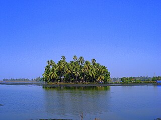
Eloor is a suburb of Kochi and a municipality in Paravur Taluk, Ernakulam District in the Indian state of Kerala, India. It is an industrial area situated around 13 kilometres north of the city centre. It is an island of 14.21 km2 formed between two distributaries of river Periyar and is the largest industrial belt in Kerala. The neighbouring places of Eloor are Kalamassery industrial hub, Aluva, Cheranalloor and Paravur.
Edathala is a gram panchayat near Aluva town. It is also a village in Aluva taluk of Ernakulam district, in the state of Kerala, India.

Kadungalloor, IPA: [kɐɖuŋːɐlːuːr], is a village situated near Aluva. The village belongs to the Paravur Taluk of the Ernakulam district in the Indian state of Kerala. The industrial estates of Muppathadam and Edayar are located in Kadungalloor.
Kottuvally is a census town in Paravoor.It is also a village in Paravur Taluk, Ernakulam district in the Indian state of Kerala. The village is situated in the south of the taluk. The nearest town is North Paravur, 4 km away. The Kottuvally panchayath is spread out on both sides of NH-66 road.

Varappuzha, IPA: [ʋɐɾɐːpːuɻɐ], is a northern suburb of the city of Kochi. It is a census town in Paravur Taluk, Ernakulam district in the Indian state of Kerala. Situated around 15 km (9 mi) from the city centre and 8 km (5 mi) from Edapally, the areas lies in the NH 66 connecting Vytilla with North Paravur. Its specialty is that considerably large-scale paddy cultivating area is situating western part of Varapuzha which is called Devaswompadam, specialised with Pokkali paddy cultivation and interim crop as fish cultivation locally called 'Kettu'. The common work of the natives are fishing and agriculture. Varapuzha is known for its fish market.
Ezhikkara is a panchayat in Paravur Taluk of Ernakulam District, Kerala. The North Paravur, Chathanad road (9 km) passes through this village. Ezhikkara is situated close to Ernakulam. Ezhikkara is famous for its pokkali fields and prawn farms.
Kuzhuppilly is a suburb of Kochi city and a tourist destination in Vypin Island in Kerala, India. The areas in Kuzhuppilly village are Pallathamkulangara, Cheruvaipu, Thundippuram, Manappally, and Ayyampilly.
Karunagappally is a municipality in the Kollam district of Kerala, India. It is 24 km north of Kollam and 60 km (37 mi) south of Alappuzha. Karunagappally taluk consists of Alappad, Ochira, Adinad, Karunagappally, Thazhava, Pavumba, Thodiyoor, Kallalibhagom, Thevalakkara, Chavara, Neendakara, Clappana, Kulasekharapuram, Thekkumbhagam, Ayanivelikulangara, Panmana, Ponmana and Vadakumthala. The taluk is bound on the north by Kayamkulam, on the east by Kunnathur taluk, on the south by Kollam and on the west by the Arabian Sea. It is one of the fastest developing towns in Kerala and is part of Kollam metropolitan area.

Rayamangalam is a village in the Ernakulam district of Kerala state, India.
Mazhuvannoor is a panchayat village in the Ernakulam district of Kerala, India. It is located in the Kunnathunad taluk. It is located near the town of Kolenchery. The panchayat headquarters are located at Airapuram.
Kumbalangi is an island village in the outskirts of Kochi city in the state of Kerala, India. Situated amidst backwaters, around 12 km (7.5 mi) from the city center, Kumbalangi is a major tourist attraction and is famous for its Chinese fishing nets. It is also known among the tourists for the occurrence of the natural phenomenon known as sea sparkle or bioluminescence in the backwaters at Kumbalangi, which is locally known as Kavaru. It is the first eco-tourism village in India, according to the government agency Kerala Tourism.
Pothanikkad or Pothanicad is a village in Ernakulam district in the Indian state of Kerala. It's also the first village to achieve 96.00% literacy in India. However, In 2011, literacy rate of Mallappally village was 96.92 % compared to 94.00 % of Kerala, the highest in India. In Mallappally Male literacy stands at 96.85 % while female literacy rate was 96.99 %. Back to the village, the name Pothanikkad derives from the Malayalam words poth, meaning buffalo, anaa, meaning elephant, and kaddu, meaning forest, as it was originally a forest with wild buffalos and elephants. Now, this small village has developed into one of the most educated and culturally advanced villages in Kerala. St. Mary's High School is the oldest high school in Pothanicad, where very prominent people in the society and many local politicians have been educated. St. John's Higher Secondary school Pulinthanam is a pioneering educational institution in the village. A government Lower Primary school and two other private Senior Secondary High schools, following CBSE curriculum, also provides better educational opportunities for the young community.
Rajakkad is a town in the Idukki district in the Indian state of Kerala situated in the Western Ghats.
Mulavana is a village in Kollam district in the state of Kerala, India. The place is filled with almost all types of shops,which includes stationary,fancy,textile etc. The Mulavana fish market is regarded as the best market while comparing with the surrounding places.

Muttom is a rural area in Idukki district in the Indian state of Kerala. This place is 66 km away from Cochin. Geographically this place is part of Midland or Idanad region of Kerala.
