This article needs additional citations for verification .(May 2025) |
South Vazhakulam Thadiyittaparambu Thekke Vazhakulam | |
|---|---|
village | |
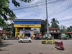 Vazhakkulam Gramapanchayat Office, Marampilli | |
 South Vazhakulam Location in Kerala, India  South Vazhakulam South Vazhakulam (India) | |
| Coordinates: 10°05′N76°25′E / 10.09°N 76.42°E | |
| Country | |
| State | Kerala |
| District | Ernakulam |
| Government | |
| • Body | Vazhakulam Panchayat |
| Population | |
• Total | 28,591 (Census data 2,001) |
| Languages | |
| • Official | Malayalam, English |
| Time zone | UTC+5:30 (IST) |
| PIN | 683105 |
| Telephone code | 0484 |
| Vehicle registration | KL-40 |
| Nearest city | Aluva, Perumbavoor |
| Lok Sabha constituency | Chalakkudy |
South Vazhakulam is a small town in between Aluva and Perumbavoor on Aluva-Munnar State Highway(SH-16). South Vazhakulam represents Vazhakulam Village, Vazhakulam Panchayat & Vazhakulam Block.
Contents
- Etymology
- Administration
- Villages and suburbs
- Location
- Economy
- Industries
- Religious Centers
- Educational Institutions
- References
Vazhakulam, which was traditionally a farming village, has changed to an industrial area with many big and small industrial units and large warehouses operating in and around Vazhakulam. South Vazhakulam is the major shopping area for the residents between Aluva and Perumbavoor towns. South Vazhakulam is preferred by many people from across the state to settle down since it is located in the suburb of Kochi and is well connected to major towns, airport, railway station, and multi-specialty hospital. People following different religious beliefs live together in harmony. Also, the crime rate is very low. Periyar Valley Irrigation Main Canal flows through Vazhakulam and so the land is supplied with water even during summer.