
Ulverston is a market town and civil parish in Westmorland and Furness, Cumbria, England. In the 2001 census the parish had a population of 11,524, increasing at the 2011 census to 11,678. Historically in Lancashire, it lies a few miles south of the Lake District National Park and just north-west of Morecambe Bay, within the Furness Peninsula. Lancaster is 39 miles (63 km) to the east, Barrow-in-Furness 10 miles (16 km) to the south-west and Kendal 25 miles (40 km) to the north-east.

Millom is a town and civil parish on the north shore of the estuary of the River Duddon in southernmost Cumberland, Cumbria, England. It is situated just outside the Lake District National Park, about six miles north of Barrow-in-Furness and 26 mi (42 km) south of Whitehaven.

Barrow-in-Furness is a port town in Westmorland and Furness, Cumbria, England. Historically in Lancashire, it was incorporated as a municipal borough in 1867 and merged with Dalton-in-Furness Urban District in 1974 to form the Borough of Barrow-in-Furness. In 2023, the borough merged with Eden and South Lakeland districts to form a new unitary authority: Westmorland and Furness. At the tip of the Furness peninsula, close to the Lake District, it is bordered by Morecambe Bay, the Duddon Estuary and the Irish Sea. In 2011, Barrow's population was 56,745, making it the second largest urban area in Cumbria after Carlisle, and the largest in Westmorland and Furness. Natives of Barrow, as well as the local dialect, are known as Barrovian.

Barrow-in-Furness was a local government district with borough status in Cumbria, England. It was named after its main town, Barrow-in-Furness. Other settlements included Dalton-in-Furness and Askam-in-Furness. It was the smallest district in Cumbria, but the most densely populated, with 924 people per square kilometre. The population was 71,980 in 2001, reducing to 69,087 at the 2011 Census.

Barrow Island is an area and electoral ward of Barrow-in-Furness, Cumbria, England. Originally separate from the British mainland, land reclamation in the 1860s saw the northern fringes of the island connected to Central Barrow. Barrow Island is also bound to the south and east by the town's dock system and to the west by Walney Channel. The Ward population taken at the 2011 census was 2,616.

Seascale is a village and civil parish on the Irish Sea coast of Cumbria, England, historically within Cumberland. The parish had a population of 1,747 in 2001, barely increasing by 0.4% in 2011.
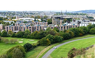
Pollock Halls of Residence is the largest halls of residence for the University of Edinburgh, located in St Leonard's, Edinburgh, Scotland, near the foot of Arthur's Seat. The complex of buildings houses more than 2,000 undergraduate students during term time, and is available to the public as bed and breakfast-style accommodation outside of the teaching term. While some of the buildings date from the 19th century, the majority of Pollock Halls dates from the 1960s and early 2000s. Pollock Halls are located on the edge of Holyrood Park, 1+1⁄4 miles (2.0 km) southeast of the centre of Edinburgh, and 3⁄4 mile (1.2 km) from the university's central area around George Square.
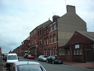
Hindpool is an area and electoral ward of Barrow-in-Furness, Cumbria, England. It is bordered by Barrow Island, Central Barrow, Ormsgill, Parkside and the Walney Channel, the local population stood at 5,851 in 2011. The ward covers the entire western half of the town centre and includes Barrow's main shopping district. Other local landmarks include the Furness College Channelside campus, the Dock Museum and the Main Public Library. Hindpool is also home to two stadia - Barrow Raiders' Craven Park and Barrow A.F.C.'s Holker Street.

Abbey Road is the principal north to south arterial road through Barrow-in-Furness, Cumbria, England.
There are 274 listed buildings in the former Borough of Barrow-in-Furness, with about 70% in Barrow-in-Furness itself. The 2015 Heritage Index formed by the Royal Society of Arts and the Heritage Lottery Fund placed the Borough as seventh highest of 325 English districts with an especially high score relating to industrial heritage assets. The Barrow Island conservation area contains dozens of historic shipyard buildings and tenements, while numerous listed buildings can be found lining Abbey Road and Duke Street, which were designed as the principal north to south and east to west thoroughfares of the Victorian planned town. Despite many buildings and structures dating from this era, an abundance of listed buildings exist throughout the Borough that pre-date Barrow, in villages that were consumed by the rapidly expanding town. One notable example being Newbarns village which retains its original 18th century street layout. Significant clusters of listed buildings can be found around the ruins of the 12th-century Furness Abbey and Market Street, the Medieval centre of Dalton-in-Furness. The oldest listed building in Barrow is Furness Abbey, dated 1127 and the newest is the John Whinnerah Institute, completed in 1934.
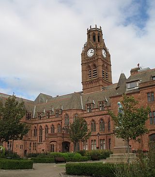
Barrow-in-Furness Town Hall is a Gothic Revival style municipal building in Barrow-in-Furness, Cumbria, England. The building, which served as the headquarters of the former Barrow Borough Council, and now one of the bases of Westmorland and Furness Council, lies within a Conservation Area with Grade II* listed status.

Furness Academy is a secondary school in Barrow-in-Furness, England. It is the fourth academy to have been formed in the county of Cumbria after the closure of Alfred Barrow School, Parkview Community College of Technology and Thorncliffe School in 2009. Having utilised numerous buildings of the former Parkview and Thorncliffe Schools since 2009, a single £22 million building opened in the Parkside area of the town in September 2013.

St Mary of Furness is a Roman Catholic church located on Duke Street in Barrow-in-Furness, England. The congregation was founded in 1858, however the current building was constructed between 1866 and 1867. It is a Grade II listed building.

St. George's Church is in St George's Square, Barrow-in-Furness, Cumbria, England. It is the oldest active Anglican parish church in the town. The church is in the deanery of Barrow, the archdeaconry of Westmorland and Furness, and the diocese of Carlisle. Its benefice is united with those of St Aidan, Newbarns, St Luke, Risedale, and St Perran, Roose, to form the South Barrow Team Ministry. The church is recorded in the National Heritage List for England as a designated Grade II listed building. It stands at the southeast extremity of the town.
The Nan Tait Centre is a Grade II listed building located at Abbey Road in the Hindpool area of Barrow-in-Furness, Cumbria, England.

The Furness Abbey Hotel was demolished in 1953, having been bombed in May 1941. Its site now forms the car park to Furness Abbey and the museum. The station at Furness Abbey also suffered bomb damage and was demolished in the early 1950s. The original station booking office and refreshment room, built in 1862, which had been attached to the hotel, survives as The Abbey Tavern, standing in Abbey Approach, Barrow-in-Furness, Cumbria, England, to the north of the remains of Furness Abbey. The current structure is recorded in the National Heritage List for England as a designated Grade II listed building.

Cooke's Building is a Grade II listed building located at 104 Abbey Road in Barrow-in-Furness, Cumbria, England. Designed by Howard Evans for businessman Henry Whiteside, Cooke's Building was built in 1875 and contains five-storey building. It served as a furniture store for the majority of its history up until 1959 when its owners; 'H Cooke and Sons' entered liquidation. During the 1980s and 1990s, Cooke's Building's basement level was home to the Sub Zero nightclub, however lay vacant during the 2000s. In 2012, a £2 million renovation was completed on behalf of Barrow Borough Council and Signal Films, who are now primary tenants of Cooke's Building using it as studios and offices. The building is bound by two other Grade II listed buildings – The Duke of Edinburgh Hotel and Oxford Chambers, the latter of which was formerly jointly listed with Cooke's Building.
Oxford Chambers is a Grade II listed building located on Abbey Road in Barrow-in-Furness, Cumbria, England. Oxford Chambers was constructed in 1875 with the intention of it functioning as a commercial property, however the new town's first higher grades school opened within the building in 1880. The school relocated to a larger premises on Duke Street in 1889. A notable feature of the building is a sign reading 'Central Cigar Depot', it also housed a shop selling office supplies in the late 20th century. Despite this, it is most known for containing the extension of the adjacent Travellers Rest social club. Oxford Chambers lies at the very northern perimeter of the Central Barrow conservation area close to The Duke of Edinburgh Hotel and the neighbouring Cooke's Building.
The following is a timeline of the history of Barrow-in-Furness, England, United Kingdom.

Piel railway station was the terminus of the Furness Railway's Piel Branch in Barrow-in-Furness, England that operated between 1846 and 1936. Located on Roa Island it was built to serve the passenger steamers at Piel Pier. The Roa Island causeway was specifically constructed for the railway, in turn making the island part of the British mainland. The station and the Piel Branch line have both been demolished, however the Roa Island Hotel which was built adjoining the station survives to this day as a Grade II listed building.

