
The Borough of Dacorum is a local government district in Hertfordshire, England that includes the towns of Hemel Hempstead, Berkhamsted, Tring and the western part of Kings Langley. The district, which was formed in 1974, had a population of 137,799 in 2001. Its name was taken from the old hundred of Dacorum which covered approximately the same area. It is the westernmost of Hertfordshire's districts, being bordered to the west by the Chiltern and Aylesbury Vale districts of Buckinghamshire.
Hemel Hempstead was a rural district in Hertfordshire, England from 1894 to 1974.
Little Gaddesden is a village and civil parish in the borough of Dacorum, Hertfordshire 3 miles (4.8 km) north of Berkhamsted. As well as Little Gaddesden village, the parish contains the settlements of Ashridge, Hudnall, and part of Ringshall. The total population at the 2011 Census was 1,125. Little Gaddesden is an area of outstanding natural beauty (AONB) and a conservation area protected by the National Trust.

Luton Hoo railway station was built by the Hertford, Luton & Dunstable Railway on the branch line between Hatfield and Dunstable. It opened in 1860 and was originally called New Mill End. In 1861 the railway was taken over by the Great Northern Railway. The name changed to Luton Hoo in 1891 and the station closed in 1965. The last passenger train, packed with enthusiasts, was hauled by Brush Type 2 D5589 on 24 April 1965.

Ashridge Commons and Woods is a 640.1 hectare biological Site of Special Scientific Interest in Buckinghamshire and Hertfordshire. It is located in Little Gaddesden, and is part of the National Trust Ashridge Estate in the Chilterns Area of Outstanding Natural Beauty.

Pegsdon Hills and Hoo Bit is a 79 hectare nature reserve in Pegsdon in Bedfordshire. It is managed by the Wildlife Trust for Bedfordshire, Cambridgeshire and Northamptonshire. The site is on the border between Bedfordshire and Hertfordshire, and it covers Pegsdon Hills and part of the adjacent Deacon Hill in Bedfordshire, and Hoo Bit in Hertfordshire. It is in the Chilterns Area of Outstanding Natural Beauty, and part of the site is designated by Natural England as the Deacon Hill SSSI.

Gaddesden Place, near Hemel Hempstead in Hertfordshire, England, was designed by architect James Wyatt and built between 1768 and 1773, and was the home of the noted Hertfordshire Halsey family.
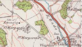
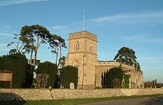
St Margaret's Convent was a convent of the Benedictine order near Great Gaddesden in Hertfordshire, England. Founded in 1160, it was abolished as a consequence of King Henry VIII's dissolution of the monasteries in the 1530s. It was also known as The Priory of Ivinghoe, St. Margaret's, in the Wood and Muresley Priory.
The Museum Tavern is a Grade II listed public house at 49 Great Russell Street, Bloomsbury, London.
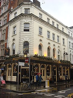
The Hoop and Grapes is a Grade II* listed public house at Aldgate High Street, Aldgate, London.

The Roebuck is a Grade II listed public house at 50 Great Dover Street, Borough, London SE1 4YG.

The Perseverance is a pub at 63 Lamb's Conduit Street, Bloomsbury, London WC1, on the corner with Great Ormond Street.
The Wrestlers is a public house on the Great North Road in Hatfield, Hertfordshire, England. The Grade II listed building has an eighteenth-century chequered red brick front, but it is based on a sixteenth-century core which preserves some of its timber framing.

St Paul's Tavern is a former pub at 56 Chiswell Street, London EC1. It is now a restaurant, the Chiswell Street Dining Rooms.

The White Horse is a public house on the south side of Castle Street, Hertford. The pub occupies numbers 31 and 33 Castle Street, two of a group of three grade II listed houses that also includes number 35. The timber-framed buildings date from the sixteenth and seventeenth centuries with later additions. The pub is under the management of Fullers Brewery.
Stud House is a house in the center of Hampton Court Park near Hampton Court Palace. Stud House is Grade II listed on the National Heritage List for England. The former stables at the house are also separately listed at Grade II. It was traditionally the official residence of the Master of the Horse.

Vicars Walker Bell MBE was a schoolteacher, and later headmaster, at Little Gaddesden Church of England School in Hertfordshire, England, from 1929 to 1963. He was also a successful author who wrote children's books, detective stories set in a rural village, and autobiographical and non-fiction works. He was described by The Times as a "village chronicler".
The Black Horse is a Grade II listed public house at 65 Blackhorse Lane in South Mimms, Hertfordshire, England. It dates from the early 18th century and is of red brick with a tiled roof. Blackhorse Lane, which may be named after the pub, was the lane along which South Mimms developed. In 1847, a police station was built there, with married quarters added in 1908, but the surrounding areas was and remains rural.
Ayot Park is a grade II listed park and garden at Ayot St Lawrence in Hertfordshire, England. It contains the grade II* listed Ayot House along with an earlier manor house and a walled kitchen garden which are also listed. The walled garden and other gardens associated with the manor house are sometimes opened to the public under the auspices of the National Gardens Scheme.

Gaddesden Hall is a Grade II* listed manor house in Water End, Great Gaddesden, Hertfordshire, England. It was the manor-house for the manor of Southall, a sub-manor of Great Gaddesden, and was originally called Southall. Later it was known as Oliver's Place after its owner from 1448, Robert Oliver. It has been known as Gaddesden Hall since the 17th century.


