
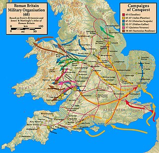
Icknield Street or Ryknild Street is a Roman road in England, with a route roughly south-west to north-east. It runs from the Fosse Way at Bourton on the Water in Gloucestershire to Templeborough in South Yorkshire. It passes through Alcester, Studley, Redditch, Metchley Fort, Birmingham, Sutton Coldfield, Lichfield, Burton upon Trent and Derby.

Littleover is a village and suburb in the city of Derby, in Derbyshire, England, between Rose Hill, Normanton, Sunny Hill and Mickleover, about 3 miles (4.8 km) southwest of Derby city centre.

Chellaston is a suburban village on the southern outskirts of Derby, in Derbyshire, England.
Duffield is a village in the Amber Valley district of Derbyshire, 5 miles (8.0 km) north of Derby. It is centred on the western bank of the River Derwent at the mouth of the River Ecclesbourne. It is within the Derwent Valley Mills World Heritage Area and the southern foothills of the Pennines.

Swadlincote is a historic mining town in the district of South Derbyshire, in the county of Derbyshire, England. It lies within The National Forest area. It borders the counties of Leicestershire and Staffordshire, 5 miles (8 km) southeast of Burton upon Trent and north-west of Ashby-de-la-Zouch and 12 miles (19 km) southwest of Derby. It covers the suburban areas of Church Gresley, Goseley, Midway, Newhall, Oversetts and Woodville and had a population of 34,576 at the 2021 census.

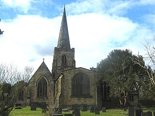
Chaddesden, also known locally as Chadd, is a large residential suburb of Derby, in the ceremonial county of Derbyshire, England. Historically a separate village centred on Chaddesden Hall and the 14th century St Mary's Church, the area was significantly expanded by 20th-century housing developments, and became part of the then County Borough of Derby in 1968, prior to Derby's city status in 1977.

Sir John Gell, 1st Baronet was an English landowner from Derbyshire, who acted as local Parliamentarian commander for most of the First English Civil War before resigning in May 1646. He was notorious for parading the body of his Royalist opponent through Derby after the Battle of Hopton Heath in March 1643.

Milford is a village in the civil parish of Belper, in the Amber Valley district, in the county of Derbyshire, England. It is on the River Derwent, between Duffield and Belper on the A6 trunk road.

Ockbrook is a village in the Erewash district, in the county of Derbyshire, England. It is almost contiguous with the village of Borrowash, the two only separated by the A52. The civil parish is Ockbrook and Borrowash. The population of this civil parish at the 2011 Census was 7,335. Ockbrook lies about 5 miles (8.0 km) east of Derby.

Draycott and Church Wilne is a civil parish within the Borough of Erewash, which is in the county of Derbyshire, England. Partially built up and otherwise rural, its population was 3,090 residents in the 2011 census. The parish is 100 miles (160 km) north west of London, 5+1⁄2 miles (8.9 km) south east of the county city of Derby, and 3 miles (4.8 km) west of the nearest market town of Long Eaton. It shares a boundary with the parishes of Breaston, Elvaston, Hopwell, Ockbrook and Borrowash, Risley and Shardlow and Great Wilne.
Derventio was a small town in the Roman province of Britannia. Today the area is known as Little Chester, on the outskirts of Derby, located in the English county of Derbyshire.

Shottle is a village approximately 3 miles (4.8 km) south of the market town of Wirksworth in Derbyshire. The population of the civil parish at the 2011 Census was 266.

Batham Gate is the medieval name for a Roman road in Derbyshire, England, which ran south-west from Templebrough on the River Don in South Yorkshire to Brough-on-Noe and the spa town of Buxton in Derbyshire. Gate means "road" in northern English dialects; the name therefore means "road to the bath town".
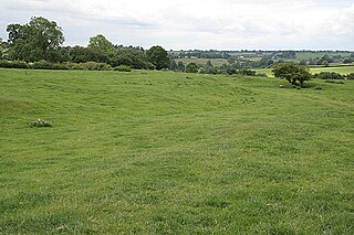
Hungry Bentley is a deserted medieval village and civil parish in the Derbyshire Dales district of Derbyshire, England, between Uttoxeter and Derby. The site is a scheduled monument and has been called the best "depopulated settlement" in Derbyshire. The name Bentley is said to mean a clearing with bent grass. The more unusual appellation of "Hungry" is said to refer to the poor quality of the land and the local inhabitants' poor food.
Strutt's Park Roman Fort was a Roman fort in Strutt's Park, a suburb of Derby in Derbyshire, England. It was built around the year 50 and replaced, probably between the years 75 and 80, by a new fort at Little Chester on the opposite bank of the River Derwent.

The Derby Racecourse Roman settlement was the third settlement in Derby or Derventio which was a small town in the Roman province of Britannia. It lies 600m east of Derventio fort in Little Chester, on the outskirts of Derby, in the English county of Derbyshire. The Roman road from Derventio to Sawley on the River Trent passes the settlement. It is a scheduled National Monument.

The Street is the medieval name of the Roman road that ran across the high limestone plateau of central Derbyshire from the spa town of Buxton southeast towards modern Derby. The line of the road can be traced from surviving features, confirmed by archaeology, from Buxton as far as Longcliffe just north of Brassington. It is believed that from Brassington the road ran eastwards to Wirksworth and there joined another road which crossed the Derwent at Milford and ran on the east bank of the Derwent and can be traced to the northern suburbs of Derby to Little Chester, the site of the Roman settlement of Derventio. The 1723 map of Brassington Moor shows The Street road from Buxton through Pikehall up to the Upper Harborough Field Gate, leading onto Manystones Lane & Brassington Lane towards Wirksworth. In records from 1613 the road from Brassington to Wirksworth is called 'Highe Streete'.
The following is a timeline of the history of the city of Derby, England.

Lutudarum was a town in the Roman province of Britannia, in the area that is now mid-Derbyshire. The settlement was believed to have been at either Wirksworth or nearby Carsington. However, Barnatt and Smith in their most recent assessment, determined that Carsington was not proven as Lutudarum, although Matlock and Cromford might be other candidates. Matlock was dismissed by its own historian Nailor in his excellent history of the Matlocks and Dennis had considered that Cromford might represent a river wharf on the Derwent but would not be Lutudarum. This leaves only Wirksworth as the likely location. The town was recorded as Lutudaron between Derventio and Veratino (Rocester) in the Ravenna Cosmography's list of all known places in the world in about 700 AD.

Ivonbrook Grange is a civil parish within the Derbyshire Dales district, in the county of Derbyshire, England. Largely rural, Ivonbrook Grange's population is reported with the population of neighbouring parishes for a total of 180 residents in 2011. It is 130 miles (210 km) north west of London, 15 miles (24 km) north west of the county city of Derby, and 3+1⁄2 miles (5.6 km) south west of the nearest market town of Matlock. Ivonbrook Grange is wholly within the Peak District national park on its southern edge, and shares a border with the parishes of Aldwark, Bonsall, Brassington, Ible as well as Winster. There is one listed structure in Ivonbrook Grange.