This article needs additional citations for verification .(November 2017) (Learn how and when to remove this template message) |
Thierhaupten | |
|---|---|
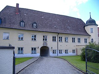
 Thierhaupten Abbey | |
 Coat of arms | |
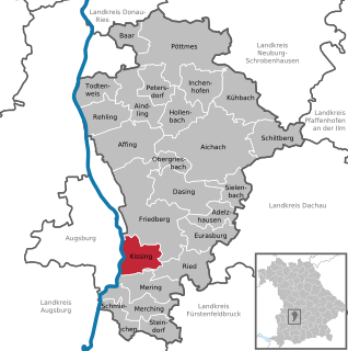
Location of Thierhaupten within Augsburg district  | |
 Thierhaupten  Thierhaupten | |
| Coordinates: 48°34′N10°55′E / 48.567°N 10.917°E Coordinates: 48°34′N10°55′E / 48.567°N 10.917°E | |
| Country | Germany |
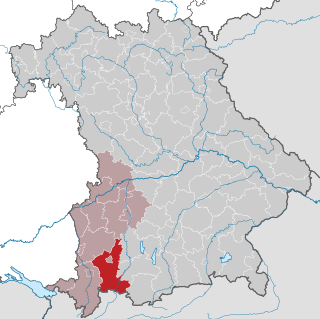
| State | Bavaria |
| Admin. region | Schwaben |
| District | Augsburg |
| Government | |
| • Mayor | Anton Brugger (CSU) |
| Area | |
| • Total | 39.19 km2 (15.13 sq mi) |
| Elevation | 430 m (1,410 ft) |
| Population (2017-12-31) [2] | |
| • Total | 4,027 |
| • Density | 100/km2 (270/sq mi) |
| Time zone | CET/CEST (UTC+1/+2) |
| Postal codes | 86672 |
| Dialling codes | 08271 |
| Vehicle registration | A |
| Website | www.thierhaupten.de |
Thierhaupten is a market town in south-central Germany in the district of Augsburg (district) in the Swabia administrative region of Bavaria, and is located at the Lech Valley.

Market town or market right is a legal term, originating in the Middle Ages, for a European settlement that has the right to host markets, distinguishing it from a village and city. On the European continent, a town may be correctly described as a "market town" or as having "market rights", even if it no longer holds a market, provided the legal right to do so still exists.

Germany, officially the Federal Republic of Germany, is a country in Central and Western Europe, lying between the Baltic and North Seas to the north, and the Alps to the south. It borders Denmark to the north, Poland and the Czech Republic to the east, Austria and Switzerland to the south, France to the southwest, and Luxembourg, Belgium and the Netherlands to the west.

Augsburg is a Landkreis (district) in Swabia, Bavaria, Germany. It is bounded by the city of Augsburg and the districts of Aichach-Friedberg, Landsberg, Ostallgäu, Unterallgäu, Günzburg, Dillingen and Donau-Ries. The city of Augsburg is not part of the district, but nonetheless is its administrative seat.