
Mount Baker, also known as Koma Kulshan or simply Kulshan, is a 10,781 ft (3,286 m) active glacier-covered andesitic stratovolcano in the Cascade Volcanic Arc and the North Cascades of Washington State in the United States. Mount Baker has the second-most thermally active crater in the Cascade Range after Mount St. Helens. About 30 miles (48 km) due east of the city of Bellingham, Whatcom County, Mount Baker is the youngest volcano in the Mount Baker volcanic field. While volcanism has persisted here for some 1.5 million years, the current volcanic cone is likely no more than 140,000 years old, and possibly no older than 80–90,000 years. Older volcanic edifices have mostly eroded away due to glaciation.

The Mount Baker–Snoqualmie National Forest in Washington is a National Forest extending more than 140 miles (230 km) along the western slopes of the Cascade Range from the Canada–US border to the northern boundary of Mount Rainier National Park. Administered by the United States Forest Service, the forest is headquartered in Everett. There are local ranger district offices in North Bend and Skykomish.
The Dennistoun Glacier is a glacier, 50 nautical miles long, draining the northern slopes of Mount Black Prince, Mount Royalist and Mount Adam in the Admiralty Mountains of Victoria Land, Antarctica. It flows northwest between the Lyttelton Range and Dunedin Range, turning east on rounding the latter range to enter the sea south of Cape Scott.
The Support Force Glacier is a major glacier in the Pensacola Mountains, draining northward between the Forrestal Range and Argentina Range to the Filchner-Ronne Ice Shelf.
Tucker Glacier is a major valley glacier of Victoria Land, Antarctica, about 90 nautical miles long, flowing southeast between the Admiralty Mountains and the Victory Mountains to the Ross Sea. There is a snow saddle at the glacier's head, just west of Homerun Range, from which the Ebbe Glacier flows northwestward.

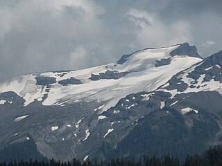
The Black Buttes, also known historically as the Sawtooth Rocks, make up an extinct stratovolcano in the Cascade Volcanic Arc in Whatcom County, Washington, United States. Glacially eroded remnants of this volcano rise above the Deming Glacier, part of the glacier system of the nearby volcano, Mount Baker. There are three major peaks — Colfax, Lincoln, and Seward — all of which can be climbed.

Coleman Glacier is located on Mount Baker in the North Cascades of the U.S. state of Washington. Between 1850 and 1950, Coleman Glacier retreated 8,200 ft (2,500 m). During a cooler and wetter period from 1950 to 1979, the glacier advanced 2,480 ft (760 m) but between 1980 and 2006 retreated back 1,443 ft (440 m). Situated on the west slopes of Mount Baker, Coleman Glacier is bordered by the Roosevelt Glacier to the north and the Heliotrope Ridge to the south.
Pryor Glacier is a glacier flowing northeastward, to the north of Mount Shields and Yermak Point, into Rennick Bay. The feature is about 30 nautical miles long and forms a physical separation between Wilson Hills and Usarp Mountains.
The Land Glacier is a broad, heavily crevassed glacier, about 35 nautical miles long, descending into Land Bay in Marie Byrd Land, Antarctica. It was discovered by the United States Antarctic Service (1939–41) and named for Rear Admiral Emory S. Land, Chairman of the United States Maritime Commission.
The Random Hills are a group of rugged hills in Victoria Land, Antarctica. They are bounded on the west by Campbell Glacier and on the east by Tinker Glacier and Wood Bay. They are centered about 15 nautical miles ) north-northwest of Mount Melbourne.

Deming Glacier is located on Mount Baker in the North Cascades of the U.S. state of Washington. Between 1850 and 1950, Deming Glacier retreated 7,217 ft (2,200 m). During a cooler and wetter period from 1950 to 1979, the glacier advanced 2,060 ft (630 m) but between 1980 and 2006 retreated back 1,140 ft (350 m). Situated on the southwest slopes of Mount Baker, Deming Glacier is bordered by the Easton Glacier to the east and the Black Buttes ridge to the west.

Hadley Glacier is located on Mount Baker in the North Cascades of the U.S. state of Washington. Situated on the north slopes of Mount Baker, Hadley Glacier is north of Hadley Peak on a spur from Mount Baker.
Mazama Glacier is located on Mount Baker in the North Cascades of the U.S. state of Washington. Between 1850 and 1950, Mazama Glacier retreated 7,700 ft (2,300 m). During a cooler and wetter period from 1950 to 1979, the glacier advanced 1,476 ft (450 m) but between 1980 and 2006 retreated back 1,509 ft (460 m). Situated on the north slopes of Mount Baker, Mazama Glacier is bordered by the Park Glacier to the south and Rainbow Glacier to the east.
Rainbow Glacier is located on the northeast slopes of Mount Baker in the North Cascades of the U.S. state of Washington. Rainbow Glacier descends to nearly 4,500 ft (1,400 m) to the north of Lava Divide. In the middle of its course, Rainbow Glacier is connected to Park Glacier to its south and Mazama Glacier to the west. Between 1850 and 1950, Rainbow Glacier retreated 4,494 ft (1,370 m). During a cooler and wetter period from 1950 to 1979, the glacier advanced 1,679 ft (512 m) but between 1980 and 2006 retreated back 1,345 ft (410 m).

Roosevelt Glacier is located on the north slopes of Mount Baker in the North Cascades of the U.S. state of Washington. Roosevelt Glacier descends to nearly 5,000 ft (1,500 m) at Chromatic Moraine. In the middle of its course, Roosevelt Glacier is connected to Coleman Glacier to its south.
Sholes Glacier is located on the northeast slopes of Mount Baker in the North Cascades of the U.S. state of Washington. The glacier lies on the north side of the ridge known as The Portals. Between 1850 and 1950, Sholes Glacier retreated 3,838 ft (1,170 m). During a cooler and wetter period from 1950 to 1979, the glacier advanced 187 ft (57 m) but between 1980 and 2006 retreated back 278 ft (85 m).
Squak Glacier is located on the southeast slopes of Mount Baker in the North Cascades of the U.S. state of Washington. Squak Glacier is connected to Easton Glacier to the east and Talum Glaciers to the west. Between 1850 and 1950, Squak Glacier retreated 8,202 ft (2,500 m). During a cooler and wetter period from 1950 to 1979, the glacier advanced 305 ft (93 m) but between 1980 and 2006 retreated back 869 ft (265 m).
The Talum Glaciers are located on the southeast slopes of Mount Baker in the North Cascades of the U.S. state of Washington. The glaciers are connected to Squak Glacier to the west. Between 1850 and 1950, the Talum Glaciers retreated 6,479 ft (1,975 m). During a cooler and wetter period from 1950 to 1979, the glaciers advanced 902 ft (275 m) but between 1980 and 2006 retreated back 951 ft (290 m).
Honeycomb Glacier is located in the Glacier Peak Wilderness in the U.S. state of Washington. The glacier is mainly in Mount Baker-Snoqualmie National Forest, but a small segment near the top of the glacier extends into Wenatchee National Forest. Honeycomb Glacier is nearly connected to White River and Suiattle Glaciers and is separated from them by an arête off the Kololo Peaks. Honeycomb Glacier is one of the largest glaciers found in the North Cascades, but since the end of the Little Ice Age, retreated 1.08 mi (1.74 km) between then and the year 2005. More than a quarter of the retreat happened between 1979 and 2005, suggesting that the rate of recession has been increasing.
Milk Lake Glacier is located in the Glacier Peak Wilderness in the U.S. state of Washington. The glacier is within Mount Baker-Snoqualmie National Forest and a little over 3 mi (4.8 km) northwest of Glacier Peak. Milk Lake Glacier disappeared sometime between 1984 and 1997 and by 2005, Milk Lake was situated where the glacier had once been.

