
Corno Grande is the highest point in the Apennine Mountains, situated in Abruzzo, central Italy. Part of the Gran Sasso massif, it is the highest peak of the Italian Peninsula at 2,912 metres (9,554 ft). It is the highest peak in mainland Italy outside of the Alps, and the second highest in the entire country outside the Alps, after Mount Etna in Sicily. It has significant vertical relief on the north side, though its south side is less elevated than the adjacent Campo Imperatore plateau.
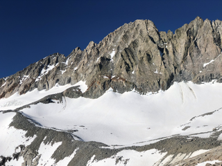
Middle Palisade is a 14,018-foot (4,273-meter) peak in the central Sierra Nevada mountain range in the U.S. state of California. It is a fourteener, and lies on the Sierra Crest as part of the Palisades group, a group of prominent Sierra Nevada mountain summits that includes multiple other fourteeners, approximately 12 miles (19 km) southwest of the town of Big Pine. Middle Palisade is the twelfth highest peak in California.

The Muskwa Ranges are a group of mountain ranges in northern British Columbia, Canada. They are part of the Northern Rockies section of the Rocky Mountains and are bounded on their west by the Rocky Mountain Trench and on their east by the Rocky Mountain Foothills. They are delimited on the north by the Liard River and on the south by the Peace Reach of the Lake Williston reservoir, south of which the next major grouping of the Rockies is the Hart Ranges.
Punta La Marmora is a mountain in the Gennargentu range, Sardinia located in Italy.

Monte Coglians is the highest mountain of the Carnic Alps, on the border between Italy and Austria (Carinthia), west of the Monte Croce Carnico pass. With its elevation of 2,780 m (9,121 ft), it is the highest peak of the Friuli-Venezia Giulia region of Italy and of the Carnic and Gailtal Alps.

Mont Blanc de Courmayeur is a point on the south-east ridge of Mont Blanc that forms the peak of the massive south-east face of the mountain. It is connected to the main summit via the Col Major.
Monte Petrella is the highest peak in the Aurunci Mountains, in southern Lazio, central Italy. It has an elevation of 1,533 metres (5,030 ft).
Monte Maggiorasca is a mountain on the border between Liguria and Emilia-Romagna, northern Italy.

The Bald Mountains are a mountain range rising along the border between Tennessee and North Carolina in the southeastern United States. They are part of the Blue Ridge Mountain Province of the Southern Appalachian Mountains. The Bald Mountains stretch from the Pigeon River in the south to the Nolichucky River in the north, and comprise parts of Cocke County, Greene County, and Unicoi County in Tennessee and parts of Madison County and Yancey County in North Carolina. The Great Smoky Mountains border the range to the south, and the Unakas rise opposite the Nolichucky to the north. The range gets its name from the relatively frequent occurrence of grassy balds atop the more prominent summits.
Birkenhead Peak, commonly known as Mount Birkenhead and sometimes Birkenhead Mountain or Mount Birken is a mountain in the Gates Valley region of the Lillooet Country of the South-Central Interior of British Columbia, Canada. Located approximately midway between the towns of Lillooet (NE) and Pemberton-Mount Currie, the mountain's very high prominence separates it from the adjoining Cadwallader Range by the pass between Blackwater Creek and Birkenhead Lake.

The Cima Undici - Elferkofel is a mountain in the Sexten Dolomites in South Tyrol, Italy.
The Hochfeiler is a mountain, 3,510 metres high, and the highest peak in the Zillertal Alps on the border between Tyrol, Austria, and South Tyrol, Italy.

The Rötspitze is a mountain in the Hohe Tauern on the border between Tyrol, Austria, and South Tyrol, Italy.
The Wilde Kreuzspitze is a mountain in the Zillertal Alps in South Tyrol, Italy.
Montalto is the highest peak of the Aspromonte, a massif in southern Calabria in Southern Italy. Located near Gambarie in the province of Reggio Calabria, it has an elevation of 1,955 metres (6,414 ft) above sea level. It is part of the Aspromonte National Park.
Monte Bondone is a mountain of Trentino, northern Italy, located west of the provincial capital of Trento. It has an elevation of 2,180 metres (7,152 ft) and includes a ski resort on one side. It is the highest mountain of the Garda Prealps and with a prominence of 1,685 metres (5,528 ft) qualifies as an Ultra. It lies between the Etschtal valley in the east and the Sarca valley in the west. Due to its location high above the city, it is often called the mountain of Trento.

Italian Mountain is a high mountain summit in the Elk Mountains range of the Rocky Mountains of North America. The 13,385-foot (4,080 m) thirteener is located in Gunnison National Forest, 13.2 miles (21.3 km) east-northeast of the Town of Crested Butte in Gunnison County, Colorado, United States. Italian Mountain was so named because the mountain's tones were said to resemble the colors of the Italian tricolor: green, white, and red.
Washakie Needles is the highest peak in the Washakie Range in the U.S. state of Wyoming. Washakie Needles is in the Washakie Wilderness of Shoshone National Forest. The Washakie Range is one of the southern group of mountains within the Absaroka Range, the other being the Owl Creek Mountains. Washakie Needles is only .8 mi (1.3 km) south of the slightly lower Dome Mountain, the second tallest peak in the Washakie Range. Part of the Absaroka volcanic field, the dacites that comprise the summit needles or pillars on Washakie Needles have been dated at 38.8 million years old, and are the youngest volcanic rocks associated with the Absarokas.

Mount Gabb is in the central Sierra Nevada in the U.S. state of California. Mount Gabb is in the John Muir Wilderness of Sierra National Forest and is named after William More Gabb, a paleontologist and member of the Whitney Survey.

The Große Eiskogel is a mountain in the Ortler Alps in South Tyrol, Italy, which rises to a height of 3,547 m s.l.m..

