Iceland is an island country at the confluence of the North Atlantic and Arctic oceans, east of Greenland and immediately south of the Arctic Circle, atop the constructive boundary of the northern Mid-Atlantic Ridge. The island country is the world's 18th largest in area and one of the most sparsely populated. It is the westernmost European country when not including Greenland and has more land covered by glaciers than continental Europe. Its total size is 103,125 km2 (39,817 sq mi) and possesses an exclusive economic zone of 751,345 km2 (290,096 sq mi).

Iceland experiences frequent volcanic activity, due to its location both on the Mid-Atlantic Ridge, a divergent tectonic plate boundary, and over a hot spot. Nearly thirty volcanoes are known to have erupted in the Holocene epoch; these include Eldgjá, source of the largest lava eruption in human history.

Mýrdalsjökull is an ice cap in the south of Iceland. It is to the north of Vík í Mýrdal and to the east of the smaller ice cap Eyjafjallajökull. Between these two glaciers is Fimmvörðuháls pass. Its peak reaches 1,493 m (4,898 ft) in height and in the year 1980 it covered an area of approximately 595 km2 (230 sq mi).

Eyjafjallajökull, sometimes referred to by the numeronym E15, is one of the smaller ice caps of Iceland, north of Skógar and west of Mýrdalsjökull. The ice cap covers the caldera of a volcano with a summit elevation of 1,651 metres (5,417 ft). The volcano has erupted relatively frequently since the Last Glacial Period, most recently in 2010, when, although relatively small for a volcanic eruption, it caused enormous disruption to air travel across northern and western Europe for a week.
The Highland is an area that comprises much of the interior land of Iceland. The Highland is situated above 300–400 meters and is mostly uninhabitable. The soil is primarily volcanic ash, and the terrain consists of basalt mountains and lava fields. Snow covers the Highland from October until the beginning of June. A few oasis-like areas such as Herðubreiðarlindir and Þórsmörk are also found in the Highland. The Highland has many natural wonders and hiking trails.

Landmannalaugar is a location in Iceland's Fjallabak Nature Reserve in the Highlands. It is on the edge of the Laugahraun lava field. This lava field was formed by an eruption in approximately 1477. It is largely known for its natural geothermal hot springs and surrounding landscape.

Skógafoss is a waterfall on the Skógá River in the south of Iceland at the cliff marking the former coastline. After the coastline had receded, the former sea cliffs remained, parallel to the coast over hundreds of kilometres, creating together with some mountains a clear border between the coastal lowlands and the Highlands of Iceland.

Seljalandsfoss is a waterfall in Iceland. Seljalandsfoss is located in the South Region in Iceland right by Route 1 and the road that leads to Þórsmörk Road 249. The waterfall drops 60 m (197 ft) and is part of the Seljalands River that has its origin in the volcano glacier Eyjafjallajökull. Visitors can walk behind the falls into a small cave.

Laugavegur is a hiking trail in South Iceland. It is the most popular trail in Iceland, with an estimated 75,000-100,000 people hiking it every year. In 2012, National Geographic listed it as one of the twenty best trails in the world.

Monte Rosa is a mountain massif in the eastern part of the Pennine Alps, on the border between Italy and Switzerland (Valais). The highest peak of the massif, amongst several peaks of over 4.000 m, is the Dufourspitze, the second highest mountain in the Alps and western Europe, after Mont Blanc. The east face of the Monte Rosa towards Italy has a height of about 2.400 meters and is the highest mountain wall of the Alps.

Skaftafell is a preservation area in Öræfi, southeast Iceland. It was once a major farm, later being named a national park. Originally known as Skaftafell National Park, it was subsequently joined together with other nearby regions to form the larger Vatnajökull National Park.

Lónsöræfi is a wilderness area in south-east Iceland. The region is characterised by its varied geological formations. These mostly date from a period between 5 and 7 million years ago, when the volcano Kollumúlaeldstöðvar was active. The glacier tongues of the eastern extreme of Vatnajökull also impose themselves on the area. Visible to the north-west is Snæfell (1833m), the highest peak in Iceland that isn't part of a glacier. The mountains within the area itself include Sauðhamarstindur (1319m) and Jökulgilstindar.

There are two base camps on Mount Everest, on opposite sides of the mountains: South Base Camp is in Nepal at an altitude of 5,364 metres (17,598 ft), while North Base Camp is in China at 5,150 metres (16,900 ft).

Tindfjallajökull is a stratovolcano in the south of Iceland. It has erupted rocks of basaltic to rhyolitic composition, and a 5-km-wide caldera was formed during the eruption of the 54,000-year-old Thórsmörk Ignimbrite. It is capped by a glacier of 19 km². Its highest peak is Ýmir (1462m), which takes its name from the giant Ýmir of Norse mythology. The most recent eruption was at an unknown time in the Holocene.

The Hausstock is a mountain in the Glarus Alps, at an elevation of 3,158 m (10,361 ft) on the border between the cantons of Glarus and Graubünden. It overlooks the valleys of Linth and Sernf rivers in Glarus, and the valley of the Vorderrhein river in Graubünden. The Hausstock was the site of the 1799 withdrawal of the Russian army under General Alexander Suvorov. A well-known destination already in the nineteenth century with British and American climbers, the mountain remains popular with mountain climbers and skiers.

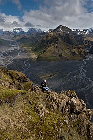
Fimmvörðuháls is the area between the glaciers Eyjafjallajökull and Mýrdalsjökull in southern Iceland. The route between Skógar and Thórsmörk goes through this pass and is one of the most popular walking routes in Iceland, despite being 22 kilometres (14 mi) long and involving 1,000 metres (3,300 ft) of climbing. There are two mountain huts along Fimmvörðuháls, one owned by hiking association Útivist, the other called Baldvinsskáli. The route from Skógar has many waterfalls along the way. The route is only accessible between mid-June and late-August. On the night of 16 May 1970, three travellers died in the mountain pass in a snowstorm.

Between March and June 2010 a series of volcanic events at Eyjafjallajökull in Iceland caused enormous disruption to air travel across Western Europe.

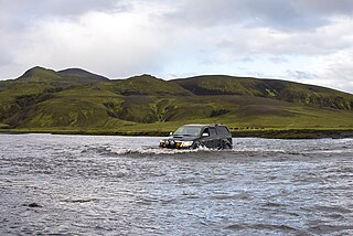
Markarfljót is a river in the south of Iceland. It is approximately 100 kilometers long.

The volcanic cone of Eldborg í Bláfjöllum is to be found at about 2 km from the skiing area in Bláfjöll, i.e. at about 25 km from Reykjavík, in Iceland.