
The Yakima River is a tributary of the Columbia River in south central and eastern Washington state, named for the indigenous Yakama people. Lewis and Clark mention in their journals that the Chin-nâm pam called the river Tâpe têtt, possibly from the French tape-tête, meaning "head hit". The length of the river from headwaters to mouth is 214 miles (344 km), with an average drop of 9.85 feet per mile (1.866 m/km). It is the longest river entirely in Washington state.

The Sauk River is a tributary of the Skagit River, approximately 45 miles (72 km) long, in northwestern Washington in the United States. It drains an area of the high Cascade Range in the watershed of Puget Sound north of Seattle. The river is a popular destination for fly fishing. It is a National Wild and Scenic River.

Goat Rocks is an extinct stratovolcano in the Cascade Range, located between Mount Rainier and Mount Adams in southern Washington, in the United States. Part of the Cascade Volcanoes, it was formed by the subduction of the Juan de Fuca Plate under the western edge of the North American Plate. The volcano was active from 3.2 million years ago until eruptions ceased between 1 and 0.5 million years ago. Throughout its complex eruptive history, volcanism shifted from silicic explosive eruptions to voluminous, mafic activity.

The Flathead River, in the northwestern part of the U.S. state of Montana, originates in the Canadian Rockies to the north of Glacier National Park and flows southwest into Flathead Lake, then after a journey of 158 miles (254 km), empties into the Clark Fork. The river is part of the Columbia River drainage basin, as the Clark Fork is a tributary of the Pend Oreille River, a Columbia River tributary. With a drainage basin extending over 8,795 square miles (22,780 km2) and an average discharge of 11,380 cubic feet per second (322 m3/s), the Flathead is the largest tributary of the Clark Fork and constitutes over half of its flow.

The Cle Elum River is a tributary of the Yakima River, approximately 28 miles (45 km) long in the U.S. state of Washington. A Northern Pacific Railway station at the future site of the city of Cle Elum, Washington was named Clealum after the Kittitas name Tie-el-Lum, meaning "swift water", referring to the Cle Elum River. In 1908, Clealum was altered to Cle Elum. This spelling came to be used for the river as well. Some maps in the 1850s also have the river labeled as Samahma River.

The Cispus River is about 54 miles (87 km) long and flows into the Cowlitz River at Lake Scanewa in the Cascade Range of Washington. Its tributaries drain most of south-central and southeastern Lewis County, extreme northeast Skamania County, and some of western Yakima County.

The Naches River is a tributary of the Yakima River in central Washington in the United States. Beginning as the Little Naches River, it is about 75 miles (121 km) long. After the confluence of the Little Naches and Bumping River the name becomes simply the Naches River. The Naches and its tributaries drain a portion of the eastern side of the Cascade Range, east of Mount Rainier and northeast of Mount Adams. In terms of discharge, the Naches River is the largest tributary of the Yakima River.

The Bumping River is a tributary of the Naches River, in Washington in the United States. It flows down the east side of the Cascade Range, through Wenatchee National Forest and the William O. Douglas Wilderness. From its source at Fish Lake near Crag Mountain, it flows northeast to Bumping Lake, a natural lake enlarged and regulated by Bumping Lake Dam. Below the dam, the Bumping River continues flowing northeast. It is joined by the American River, its main tributary, a few miles above its mouth where it joins the Little Naches River to form the Naches River.
The American River is a tributary of the Bumping River in Washington. It flows down the east side of the Cascade Range, through Wenatchee National Forest and the William O. Douglas Wilderness.

Rimrock Lake is a lake along the course of the Tieton River, in Yakima County, Washington state, US.

Kachess Lake is a lake and reservoir along the course of the Kachess River in Kittitas County, Washington, United States. The upper part of the lake, north of a narrows, is called Little Kachess Lake. The Kachess River flows into the lake from the north, and out from the south. Kachess Lake is the middle of the three large lakes which straddle Interstate 90 north of the Yakima River in the Cascade Range. The other two are Cle Elum Lake, the easternmost which is also north of I-90 and Keechelus Lake, the westernmost, which is south of I-90.

Kachess River is a tributary of the Yakima River, in the U.S. state of Washington. From its source on Chickamin Ridge in the Alpine Lakes Wilderness region of the Cascade Range, the Kachess River flows south into Kachess Lake, a natural lake regulated as a reservoir by Kachess Dam. Below the dam, the Kachess River flows south and then empties into the Yakima River at Lake Easton.

The Teanaway River is a tributary of the Yakima River, in the U.S. state of Washington. It flows into the Yakima River near Cle Elum. The Teanaway River is part of the Columbia River basin, being a tributary of the Yakima River, which is a tributary to the Columbia River. The river's name comes from Sahaptin, possibly /tyawnawí-ins/, "drying place".

Tieton Dam is an earth and concrete type dam on the Tieton River in Yakima County, in the U.S. state of Washington. The dam began operation in 1925. Its reservoir, Rimrock Lake, has a total capacity of 203,600 acre-feet (0.2511 km3) with a normal operating capacity of 198,000 acre-feet (0.244 km3) to provides water for agricultural irrigation. This dam is a component of the Yakima Project. Tieton Dam also produces electricity for Burbank Water and Power and Glendale Water and Power, near Los Angeles. The Southern California Public Power Agency installed two 7 megawatt generators in a project started in 2010. The power is transmitted over the DC Intertie that runs from Celilo, Oregon to Sylmar, California. Upstream from the dam, the river is impounded by Clear Creek Dam, another element of the Yakima Project. About 8 miles (13 km) downstream from the dam, the Tieton River is tapped for the Tieton Main Canal.
The Foss River is a stream in the U.S. state of Washington. It has two main forks, the East Fork Foss River and the West Fork Foss River. The main stem is formed by the confluence of the two forks. The river and its forks rise near in the Alpine Lakes Wilderness area of Mount Baker-Snoqualmie National Forest in the Cascade Mountains and flows generally north, joining the Tye River to form the South Fork Skykomish River. The Foss River's waters eventually empty into Puget Sound near Everett via the Skykomish River and Snohomish River.

Little Butte Creek is a 17-mile-long (27 km) tributary of the Rogue River in the U.S. state of Oregon. Its drainage basin consists of approximately 354 square miles (917 km2) of Jackson County and another 19 square miles (49 km2) of Klamath County. Its two forks, the North Fork and the South Fork, both begin high in the Cascade Range near Mount McLoughlin and Brown Mountain. They both flow generally west until they meet near Lake Creek. The main stem continues west, flowing through the communities of Brownsboro, Eagle Point, and White City, before finally emptying into the Rogue River about 3 miles (5 km) southwest of Eagle Point.
The Ohanapecosh River is a 16-mile (26 km) river in the U.S. state of Washington.

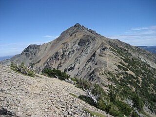
Ives Peak, elevation 7,920+ ft, is located in the Goat Rocks on the border of Lewis and Yakima Counties, in the U.S. state of Washington. Ives Peak is within the Goat Rocks Wilderness and the McCall Glacier on its eastern slopes. Additionally, the Pacific Crest National Scenic Trail is near the west slopes of the peak. Precipitation runoff from the peak's east slope drains to the Tieton River, whereas the west slope drains into the Cispus River. Ives Peak ranks as the fourth-highest peak in the Goat Rocks Wilderness.
Mount Aix is a 7,766-foot (2,367 m) mountain summit in Yakima County of Washington state.

Tieton Peak is a 7,768-foot-elevation (2,368-meter) mountain summit in Yakima County of Washington state.

