Timbavati Private Nature Reserve

Last updated

Timbavati Private Nature Reserve
Leopard drinking 1 1.jpg
African leopard at Tanda Tula Camp
South Africa Mpumalanga relief location map.svg
Red pog.svg
Location in Mpumalanga province
Location Mpumalanga, South Africa
Nearest city Nelspruit
Coordinates 24°20′07″S31°20′38″E / 24.33528°S 31.34389°E / -24.33528; 31.34389
Area53,392 hectares (533.92 km2) [1] [2]
Established1956 [3] [4]
www.timbavati.co.za

The Timbavati Private Nature Reserve is located at the border line between Hoedspruit (in Limpopo) and Acornhoek (in Mpumalanga), north of the Sabi Sand Private Game Reserve on the western edge of Kruger National Park. Geographically and politically, Timbavati is located in Mpumalanga Province. In Xitsonga, the name 'Timbavati' means "the place where something sacred came down to Earth from the Heavens", and refers to the rare white lions of Timbavati.

Contents

The reserve was established in 1956 by like-minded game farmers with the creation of the Timbavati Association. The association has 50 members and covers 53,392 hectares (533.92 km2). [1] [2] Timbavati is part of Associated Private Nature Reserves (APNR) and the fences separating Timbavati from the other member reserves in the APNR and from the Kruger National Park has been removed. [5] Wildlife, including lions, cheetahs, elephants and other species, roam freely between these reserves. Ngala (meaning 'lion' in Tsonga) and Motswari game reserves have been amalgamated into Timbavati.

History

In 1956, a group of conservation minded landowners formed the Timbavati Association with the aim to reclaim the land for the benefit of all. They had come together after witnessing the degradation of a once pristine wilderness area.

Insensitive land use (primarily crop and cattle farming) had caused soil erosion and destruction of indigenous plant species. In addition, natural water sources had been rerouted by dams further impacting on the natural status quo. As a result, much of the wildlife common to the area was lost.

Since the formation of the Timbavati Association, every landowner in the area has been encouraged to join in the conservation effort. Today there are over 50 members who have succeeded in restoring the land to its former glory, with diverse and rare wildlife species making the Timbavati their home.

In 1993, in recognition of the importance of the area, the fences between the Kruger National Park and the Timbavati Reserve were removed to encourage natural species migration.

Man's incursions into this part of the Lowveld have always been temporary and brief, from early stone age down to the early 20th century. In point of fact, large tracts of land in the northern portion of the Lowveld were never permanently settled by man. The lands now comprising the Timbavati were barely touched, and are still only lightly inhabited. This part of South Africa's bushveld region may therefore be regarded as truly unspoiled and deserves recognition as genuine wild land, as opposed to the "restored" and "restocked" lands commonly found elsewhere.

Geography

The Timbavati Private Nature Reserve is located in the Mpumalanga province of South Africa [6] between latitudes 24° 34’ S and 24° 03’ S and longitudes 31° 03’ E and 31° 31’ E. The Timbavati Reserve consists of 50 contiguous tracts of land housing 12 luxury tourist lodges.

The reserve forms part of the Greater Kruger National Park and lies nestled between the Kruger National Park on the east, the Klaserie and Umbabat Game Reserves in the north and the Thornybush Game Reserve in the west. There are no fences between the Timbavati and the Kruger National Park which allows free movement of wildlife between the reserves. The world-famous Kruger National Park is a conservation area of more than 20,000 square kilometres (7,700 sq mi).

The southern border of this great complex of public and privately owned protected land lies close to the Kingdom of Eswatini and abuts the boundaries of Zimbabwe in the north and Mozambique in the east.

The terrain is undulating with altitudes varying between 300 and 500m above sea level. The area is characterised as 'savanna bushveld' with 6 different landscape types: acacia woodland, open woodland, mopane woodland, combretum woodland, mixed combretum woodland and mixed veld on Gabbro. Bush elephants, African buffaloes, kudu, Burchell's zebras, blue wildebeests, Cape giraffes, impalas, waterbucks and warthogs abound together with their attendant predators including lions, African leopards, South African cheetahs and spotted hyena. The endangered Cape wild dog is also a regular visitor to the Timbavati Game Reserve. The larger and rarer antelopes such as roan antelope, common eland and tsessebe have been slow to return to this area and their numbers are still critically low.

The climate is typified by a summer wet season (October–March) with the majority of rain falling between December and February. This is also the hottest time of the year, with temperatures in the region of 32 °C. A typical summer day will be hot with storm clouds gathering for a spectacular late afternoon thunderstorm.

During the winter months (April–September) the weather is dry with little chance of rain. As game tends to congregate around dwindling water sources, game viewing is more predictable. Temperatures can range from 28 °C to 10 °C in one day. The mornings and evenings can be very cold and warm clothing is very strongly recommended.

Flora and fauna

Sunset over Timbavati Game Reserve. TimbavatiSunset.jpg
Sunset over Timbavati Game Reserve.

Timbavati is home to:

White lions

A white lion cub at Kromdraai, South Africa. Whitelioncub.jpg
A white lion cub at Kromdraai, South Africa.

When the white lions of the Timbavati were discovered in the mid-1970s they became the subject of much interest and debate. The story of the "White Lions of the Timbavati" has been told by several people, including Chris McBride. McBride was the son of Timbavati member Cyril McBride, who at the time owned the farm Vlakgezicht, together with his brother Robert.

Lions with a recessive gene causing the coats to be snow white (though not albino) reappeared in the Timbavati in 2006 after an absence of many years. [7] Their white coats are not the product of albinism, a relatively common condition resulting from a failure to develop pigment, but from another condition called "leucism," in which the pelt is white but eyes and skin are pigmented. The condition is rare and also termed a "chinchilla mutation." It is thought to represent an evolutionary stage in the progressive loss of pigmentation. The white mutation, which affects two of the pigments involved in coat coloration, is expressed only when two conditions pertain: (1) Both parents carry the recessive "white gene"; (2) the offspring inherit the recessive gene of each parent. If a cub receives a dominant "tawny" gene from either parent, its pelt will be tawny. Thus a litter may contain both tawny and white cubs.[ citation needed ]

Disease

Malaria is present in the area. [8]

See also

Related Research Articles

<span class="mw-page-title-main">Kruger National Park</span> First national park in South Africa

Kruger National Park is a South African National Park and one of the largest game reserves in Africa. It covers an area of 19,623 km2 (7,576 sq mi) in the provinces of Limpopo and Mpumalanga in northeastern South Africa, and extends 360 km (220 mi) from north to south and 65 km (40 mi) from east to west. The administrative headquarters are in Skukuza. Areas of the park were first protected by the government of the South African Republic in 1898, and it became South Africa's first national park in 1926.

<span class="mw-page-title-main">Mpumalanga</span> Province of South Africa

<span class="mw-page-title-main">Gonarezhou National Park</span> National park in Zimbabwe

Gonarezhou National Park is a national park located in southeastern Zimbabwe. It is situated in a relatively remote corner of Masvingo Province, south of Chimanimani along the Mozambique border. Owing to its vast size, rugged terrain and its location away from main tourist routes, large tracts of Gonarezhou remain pristine wilderness.

<span class="mw-page-title-main">James Stevenson-Hamilton</span>

James Stevenson-Hamilton served from 1902–1946 as the first warden of South Africa's Sabi Nature Reserve, which was expanded under his watch and became Kruger National Park in 1926. The Tsonga people nicknamed him Skukuza because when he arrived at the area of the reserve he "turned everything upside down" with the banning of all hunting in the reserve and the relocation of all the native kraals. Skukuza camp and Skukuza Airport is named in honour of Stevenson-Hamilton, who is regarded as a champion of wildlife Conservation in South Africa.

<span class="mw-page-title-main">Hazyview</span> Place in Mpumalanga, South Africa

Hazyview is a sub-tropical farming town in Mpumalanga, South Africa, renowned for its large banana and macadamia nut industries, contributing about 20% of South Africa's bananas and 30% of macadamia output. Bordering the Kruger National Park, the town's name is derived from the shimmering haze that occurs during the heat of summer. Most of the province of Mpumalanga's private game reserves are found just east of Hazyview.

<span class="mw-page-title-main">Highveld</span> Geographic region of the South African inland plateau

The Highveld is the portion of the South African inland plateau which has an altitude above roughly 1500 m, but below 2100 m, thus excluding the Lesotho mountain regions to the south-east of the Highveld. It is home to some of the country's most important commercial farming areas, as well as its largest concentration of metropolitan centres, especially the Gauteng conurbation, which accommodates one-third of South Africa's population.

<span class="mw-page-title-main">White lion</span> Rare colour mutation of the Kruger subspecies of lion

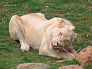
The white lion is a rare colour mutation of the lion, specifically the Southern African lion. White lions in the area of Timbavati are thought to have been indigenous to the Timbavati region of South Africa for centuries, although the earliest recorded sighting in this region was in 1938. White lions first became known to the English-speaking world in 1977 through the book The White Lions of Timbavati.

<span class="mw-page-title-main">Wildlife of Botswana</span> Flora and fauna of Botswana

The wildlife of Botswana refers to the flora and fauna of this country. Botswana is around 90% covered in savanna, varying from shrub savanna in the southwest in the dry areas to tree savanna consisting of trees and grass in the wetter areas. Even under the hot conditions of the Kalahari Desert, many species survive; in fact the country has more than 2500 species of plants and 650 species of trees. Vegetation and its wild fruits are also extremely important to rural populations living in the desert and are the principal source of food, fuel and medicine for many inhabitants.

<span class="mw-page-title-main">Wildlife of Zimbabwe</span> Native fauna and flora of Zimbabwe

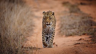
The wildlife of Zimbabwe occurs foremost in remote or rugged terrain, in national parks and private wildlife ranches, in miombo woodlands and thorny acacia or kopje. The prominent wild fauna includes African buffalo, African bush elephant, black rhinoceros, southern giraffe, African leopard, lion, plains zebra, and several antelope species.

Blyde River Canyon Nature Reserve is situated in the Drakensberg escarpment region of eastern Mpumalanga, South Africa. The reserve protects the Blyde River Canyon, including sections of the Ohrigstad and Blyde Rivers and the geological formations around Bourke's Luck Potholes, where the Treur River tumbles into the Blyde below. Southwards of the canyon, the reserve follows the escarpment, to include the Devil's and God's Window, the latter a popular viewpoint to the lowveld at the reserve's southern extremity.

<span class="mw-page-title-main">Balule Nature Reserve</span> Protected area in Limpopo Province, South Africa

Balule Nature Reserve is a protected area in Limpopo Province, South Africa which forms part of the Greater Kruger National Park as a member of the Associated Private Nature Reserves (APNR). As part of a wildlife conservation initiative, all fences separating APNR reserves – Balule, Timbavati, Klaserie, Umbabat, – and the Kruger National Park have been removed.

<span class="mw-page-title-main">Thornybush Game Reserve</span>

Thornybush Game Reserve is a private game reserve, near Hoedspruit, in the Limpopo province of South Africa. It borders the Kapama Game Reserve and is located close to the Timbavati Game Reserve and the Kruger Park. The Reserve's surface area is approximately 14,000 ha of mainly open savannah.

<span class="mw-page-title-main">Klaserie Game Reserve</span>

Klaserie Game Reserve is adjacent to the Kruger Park and the Timbavati Game Reserve, in the Limpopo province of South Africa. It has an area of about 60,000 ha and the Klaserie River runs through the park.

<span class="mw-page-title-main">Associated Private Nature Reserves</span>

Associated Private Nature Reserves, (APNR), is an association of privately owned nature reserves bordering on the Kruger National Park. Collectively they represent 1,800 square kilometres (180,000 ha) of land dedicated to conservation. In June 1993 the fences between Kruger National Park and the APNR were removed.

<span class="mw-page-title-main">Ulusaba Private Game Reserve</span>

Ulusaba Private Game Reserve, owned by Sir Richard Branson as part of the Virgin Limited Edition luxury property portfolio, consists of about 13,500 ha of land set in the heart of the Sabi Sand Private Game Reserve. This private game reserve borders on the sprawling Kruger National Park in South Africa's Mpumalanga province and is home to an abundance of wildlife. Ulusaba means fearful in the local Tsonga (Shangaan) language and it was a name given to the Sabie River by the Shangaan people. The Sabie River was originally called Ulusaba by the Shangaan simply because there was once a large concentration of dangerous Nile crocodile in the river. Before the establishment of the Kruger National Park, Ulusaba was once a home of Tsonga-Shangaan people, the Shangaan were evicted from this land when the Kruger National Park was established and were relocated in nearby villages adjacent Ulusaba Private Game Reserve.

Moditlo Private Game Reserve forms an integral part of the 10 000 hectare Blue Canyon Private Game Reserve, located near Hoedspruit, Limpopo Province, South Africa. The reserve borders Kapama Game Reserve to the eastern side, the Drakensberg Mountains forms the backdrop to the west, and falls into the southern/central region of the Greater Kruger Park biosphere. The size of the Blue Canyon Conservancy has now reached 36,000 acres in total, and is home to typical African game such as lions, elephants, leopards, rhinos, cheetahs, hippos and several hundreds of bird species typical to the lowveld in South Africa. The reserve is also home to a pack of wild dogs, which is the second rarest carnivore species in Africa with only an estimated 2000 remaining specimen in existence.

<span class="mw-page-title-main">Sabi Sand Game Reserve</span> Reserve in South Africa

Sabi Sand Game Reserve is located adjacent to the Kruger National Park in the Lowveld of Mpumalanga, South Africa. Officially named Sabi Sand Wildtuin, the Sabi Sand Game Reserve consists of a group of private game reserves. The Newington Gate is at 24°52′9″S31°24′16″E and west of the Kruger Gate and Skukuza camp of Kruger Park. Other entrances are Gowrie Gate in the far north and Shaws Gate in the south.

Mapesu Private Game Reserve is a game reserve in Limpopo Province, South Africa. The reserve adjoins the Mapungubwe National Park and World Heritage Site, with which it shares a 12.5 km Northern border. The main entrance gate to the reserve is located approximately 7 km east of Mapungubwe's entrance gate. It was established in 2014 and covers an area of over 7,200 hectares. The reserve protects various bird, mammal and tree species and is slated to become part of the Greater Mapungubwe Transfrontier Conservation Area in phase 2 as part of the proposed Limpopo Valley Game Reserve.

<span class="mw-page-title-main">Nhlaralumi River</span> River in South Africa

The Nhlaralumi River is a right bank tributary of the Olifants River in the Kruger National Park, in northern Mpumalanga, South Africa. Its origin is in Thornybush Game Reserve. Its northeastwards course takes it through the Timbavati Game Reserve, Umbabat Nature Reserve and eventually the western Kruger Park.

References

  1. 1 2 "Timbavati Private Nature Reserve (TPNR)". Simbavati River Lodge. Archived from the original on 15 December 2009. Retrieved 11 December 2009.
  2. 1 2 Turner, Jason (November 2005). "The impact of lion predation on the large ungulates of the Associated Private Nature Reserves, South Africa". Pretoria: University of Pretoria. pp. 49 & 56. Retrieved 10 December 2009.
  3. Harrison, Philip (2004). Ecotravel. Vol. 2 of South Africa's top sites. New Africa Books. p. 42. ISBN   0-86486-566-X.
  4. Oosthuizen, Johan (2009). "The Development of an Integrated wildlife disease surveillance and monitoring system for the disease management in free ranging wildlife in the Greater Kruger National Park" (PDF). Retrieved 10 December 2009.
  5. "Save the Elephants Annual Report (2008)" (PDF). Save the Elephants. August 2008. p. 13. Retrieved 10 December 2009.[ permanent dead link ]
  6. "Location and Map". Timbavati Private Nature Reserve. Retrieved 17 June 2013.
  7. Macleod, Fiona (18 March 2005). "White lions return to Timbavati". Mail & Guardian . Retrieved 11 December 2009.
  8. "GUIDELINES FOR THE PREVENTION OF MALARIA IN SOUTH AFRICA" (PDF). South African Department of Health. p. 40. Archived from the original (PDF) on 16 February 2010. Retrieved 11 December 2009.