
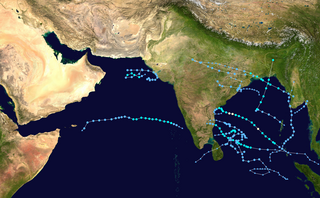
The 2007 North Indian Ocean cyclone season was one of the most active North Indian Ocean cyclone seasons on record. The North Indian Ocean cyclone season has no official bounds, but cyclones tend to form between April and December, with peaks in May and November. These dates conventionally delimit the period of each year when most tropical cyclones form in the northern Indian Ocean.
Below is a timeline of the 2007 North Indian Ocean cyclone season, documenting major events with regards to tropical cyclone formation, strengthening, weakening, landfall, extratropical transition, as well as dissipation. The 2007 North Indian Ocean cyclone season was an ongoing event in the annual cycle of tropical cyclone formation.

The 2002 North Indian Ocean cyclone season was a below average season in terms of tropical cyclone formation. The season had no official bounds, but most storms formed in either May or after October. No depressions or storms formed during the monsoon season from July to September, the first such instance on record. There are two main seas in the North Indian Ocean – the Bay of Bengal to the east of the Indian subcontinent – and the Arabian Sea to the west of India. The official Regional Specialized Meteorological Centre in this basin is the India Meteorological Department (IMD), while the Joint Typhoon Warning Center (JTWC) releases unofficial advisories. An average of four to six storms form in the North Indian Ocean every season with peaks in May and November. Cyclones occurring between the meridians 45°E and 100°E are included in the season by the IMD.

The 2008 North Indian Ocean cyclone season officially ran throughout the year during 2008, with the first depression forming on April 27. The timeline includes information that was not operationally released, meaning that information from post-storm reviews by the Joint Typhoon Warning Center (JTWC), and the India Meteorological Department (IMD), such as information on a storm that was not operationally warned on. This timeline documents all the storm formations, strengthening, weakening, landfalls, extratropical transitions, as well as dissipation's during the 2008 North Indian Ocean cyclone season.

The 2009 North Indian Ocean cyclone season was an event in the annual cycle of tropical cyclone formation. The North Indian Ocean cyclone season has no official bounds, but cyclones tend to form between April and December, with peaks in May and November. These dates conventionally delimit the period of each year when most tropical cyclones form in the northern Indian Ocean.

Cyclonic Storm Rashmi was the seventh tropical cyclone of the 2008 North Indian Ocean cyclone season and second cyclonic storm, as well as the fifth tropical cyclone in the Bay of Bengal that year. A fairly weak tropical cyclone, it caused some notable damage in Bangladesh and India.

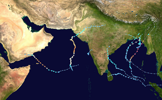
The 2010 North Indian Ocean cyclone season was one of the most active tropical cyclone season in the North Indian Ocean since 1998. The season saw 8 depressions and 5 named storms forming in the region.
This is a timeline of the 2009 North Indian Ocean cyclone season, which contains details of when a depression forms, strengthens, weakens, makes landfalls, and dissipates during the 2009 North Indian Ocean cyclone season. It also includes information from post-storm analysis by the Joint Typhoon Warning Center (JTWC), and the India Meteorological Department (IMD) who run the Regional Specialized Meteorological Center in New Delhi, India. RSMC New Delhi's area of responsibility is officially between 45°E and 100E which is east of the Horn of Africa and west of the Malay Peninsula. There are two main seas within the North Indian Ocean, the Arabian Sea and the Bay of Bengal. For storms, these are abbreviated as BOB and ARB by the IMD.

The 2011 North Indian Ocean cyclone season was the least active tropical cyclone season in the North Indian Ocean since 1993. Only two cyclonic storms formed, below the average of four to six. The North Indian Ocean cyclone season has no official bounds, but cyclones tend to form between April and December, with peaks in May and November. These dates conventionally delimit the period of each year when most tropical cyclones form in the northern Indian Ocean. The scope of this article is limited to the Indian Ocean in the Northern Hemisphere, east of the Horn of Africa and west of the Malay Peninsula. There are two main seas in the North Indian Ocean — the Arabian Sea to the west of the Indian subcontinent, abbreviated ARB by the India Meteorological Department (IMD); and the Bay of Bengal to the east, abbreviated BOB by the IMD.

The 2012 North Indian Ocean cyclone season was a very inactive season. The season had a very late start, with the first system forming in October. During the season, only five systems formed, of which only two became cyclonic storms. Both the storms made landfall, and they, along with the deep depressions, were responsible for 128 deaths and economic losses worth at least $56.7 million.

The 2013 North Indian Ocean cyclone season was an event in the annual cycle of tropical cyclone formation, in which tropical cyclones formed in the North Indian Ocean and Arabian Sea. The season had no official bounds, but cyclones typically formed between May and December, with the peak from October to November. These dates conventionally delimit the period of each year when most tropical cyclones form in the northern Indian Ocean.

The 2014 North Indian Ocean cyclone season was an event in the annual cycle of tropical cyclone formation. The season included two very severe cyclonic storms, both in October, and one other named cyclonic storm, classified according to the tropical cyclone intensity scale of the India Meteorological Department. Cyclone Hudhud is estimated to have caused US$3.58 billion in damage across eastern India, and more than 120 deaths.

Severe Cyclonic Storm Helen was a relatively weak tropical cyclone that formed in the Bay of Bengal Region on 18 November 2013, from the remnants of Tropical Storm Podul. It was classified as Deep Depression BOB 06 by the IMD on 19 November. As it was moving on a very slow northwest direction on 20 November, it became Cyclonic Storm Helen as it brought light to heavy rainfall in eastern India. It then became a Severe Cyclonic Storm on the afternoon hours of 21 November.

The 2016 North Indian Ocean cyclone season was an event in the annual cycle of tropical cyclone formation. It was the deadliest season since 2010, killing more than 400 people. The season was an average one, seeing four named storms, with one further intensifying into a very severe cyclonic storm. The first named storm, Roanu, developed on 19 May while the season's last named storm, Vardah, dissipated on 18 December. The North Indian Ocean cyclone season has no official bounds, but cyclones tend to form between April and December, with the two peaks in May and November. These dates conventionally delimit the period of each year when most tropical cyclones form in the northern Indian Ocean.

The 2020 North Indian Ocean cyclone season was the costliest North Indian Ocean cyclone season on record, mostly due to the devastating Cyclone Amphan. The North Indian Ocean cyclone season has no official bounds, but cyclones tend to form between April and November, with peaks in late April to May and October to November. These dates conventionally delimit the period of each year when most tropical cyclones form in the northern Indian Ocean. The season began on May 16 with the designation of Depression BOB 01 in the Bay of Bengal, which later became Amphan. Cyclone Amphan was the strongest storm in the Bay of Bengal in 21 years and would break Nargis of 2008's record as the costliest storm in the North Indian Ocean. The season concluded with the dissipation of Cyclone Burevi on December 5. Overall, the season was slightly above average, seeing the development of five cyclonic storms.

The 2015 North Indian Ocean cyclone season was a below-average tropical cyclone season which featured the highest number of deaths since the 2010 season. Despite inactivity in the Bay of Bengal caused by the ongoing El Niño, the season produced an above-average number of tropical cyclones in the Arabian Sea. The first storm of the season, Ashobaa, formed on 7 June, while the final storm of the season, Megh, ultimately dissipated on 10 November.

The 2021 North Indian Ocean cyclone season was an average season, the North Indian Ocean cyclone season has no official bounds, but cyclones tend to form between April and December, peaking between May and November. These dates conventionally delimit the period of each year when most tropical cyclones form in the northern Indian Ocean. The season began on April 2, when a depression designated as BOB 01 was formed in the north Andaman Sea and quickly made landfall in Myanmar. The basin remained quiet for over a month before Cyclone Tauktae formed. It rapidly intensified into an extremely severe cyclonic storm before making landfall in Gujarat, become the strongest storm ever to strike that state since the 1998 Gujarat cyclone. Later that month, BOB 02 formed and later strengthened into Cyclone Yaas. Yaas rapidly intensified into a very severe cyclonic storm before making landfall in northwestern Odisha. The season's strongest tropical cyclone was Cyclone Tauktae, with maximum wind speeds of 185 km/h (115 mph) and a minimum barometric pressure of 950 hPa (28.05 inHg).
The 2022 North Indian Ocean cyclone season was an event in the annual cycle of tropical cyclone formation. It was an above-average season in terms of depressions and average in terms of deep depressions, but slightly below average in terms of cyclonic storms. It was also the least deadly North Indian Ocean cyclone season since 1988, according to official data. The season's strongest tropical cyclone was Cyclone Asani, with maximum wind speeds of 100 km/h and a minimum barometric pressure of 982 hPa. The North Indian Ocean cyclone season has no official bounds, but cyclones tend to form between April and December, with the peak from May to November. These dates conventionally delimit the period of each year when most tropical cyclones form in the northern Indian Ocean.
The 2013 North Indian Ocean cyclone season was an average season during the period of tropical cyclone formation in the North Indian Ocean. The season began in May with the formation of Cyclone Viyaru, which made landfall on Bangladesh, destroying more than 26,500 houses. After a period of inactivity, Cyclone Phailin formed in October, and became an extremely severe cyclonic storm. Additionally, it was a Category 5-equivalent cyclone on the Saffir–Simpson hurricane wind scale. It then made landfall in the Indian states of Andhra Pradesh and Odisha, becoming the most intense cyclone to strike the country since the 1999 Odisha cyclone. In November, cyclones Helen and Lehar formed, and they both made landfall in Andhra Pradesh just one week away from each other. The latter also affected the Andaman and Nicobar Islands.
The 2023 North Indian Ocean cyclone season was an above-average and deadly season, becoming the deadliest season since 2017, mainly due to Cyclone Mocha. With nine depressions and six cyclonic storms forming, it became the most active season, featuring the second-highest accumulated cyclone energy (ACE) on record only behind 2019. It also had the most extremely severe cyclonic storms on record, tieing with 1999 and 2019. The North Indian Ocean cyclone season has no official bounds, but cyclones tend to form between April and December, with the peak from May to November. These dates conventionally delimit the period of each year when most tropical cyclones form in the northern Indian Ocean. However, a cyclone can form at any time during the year shown by an unnamed depression that affected Sri Lanka in January-February.


