Bas-Rhin is a département in Alsace which is a part of the Grand Est super-region of France. The name means 'Lower Rhine', referring to its lower altitude among the two French Rhine departments: it is downstream of the Haut-Rhin department. Both belong to the European Upper Rhine region. It is, with the Haut-Rhin, one of the two departments of the traditional Alsace region which until 1871, also included the area now known as the Territoire de Belfort. The more populous and densely populated of the pair, it had 1,152,662 inhabitants in 2021. The prefecture is based in Strasbourg. The INSEE and Post Code is 67.

The Marquesas Islands are a group of volcanic islands in French Polynesia, an overseas collectivity of France in the southern Pacific Ocean. Their highest point is the peak of Mount Oave on Ua Pou island, at 1,230 m (4,035 ft) above sea level.

Saguenay is a city in the Saguenay–Lac-Saint-Jean region of Quebec, Canada, on the Saguenay River, about 200 kilometres (120 mi) north of Quebec City by overland route. It is about 126 kilometres (78 mi) upriver and northwest of Tadoussac, located at the confluence with the St. Lawrence River. It was formed in 2002 by merging the cities of Chicoutimi and Jonquière and the town of La Baie. Chicoutimi was founded by French colonists in 1676. As of July 2021, the city had a population of 145,000 and the metropolitan area had a population of 165,000.

Mamfe or Mamfé is a city in and the capital of Manyu, a division of the Southwest Region in Cameroon. It is 74 km (46 mi) from the border of Nigeria, on the Manyu River. It has a population of 42,500
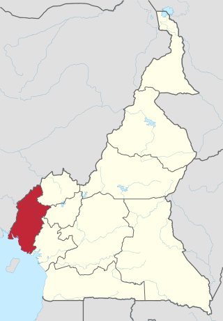
The Southwest Region or South-West Region is a region with special status in Cameroon. Its capital is Buea. As of 2015, its population was 1,553,320. Along with the Northwest Region, it is one of the two Anglophone (English-speaking) regions of Cameroon. Various Ambazonian nationalist and separatist factions regard the South-West region as being distinct as a polity from Cameroon.
Carnot is a city located in the south west of the Central African Republic (CAR), in the prefecture of Mambéré.
Etuko is a village in Cameroon located in the Department of Manyu in the Southwest Region. It is administratively attached to the district of Upper Bayang and to the canton of Bachuo Akagbe. The village is located 43 kilometres (27 mi) from Mamfe and 105 km (65 mi) from Bamenda.
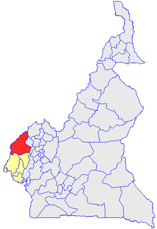
Manyu is a division of the Southwest Region in Cameroon. The division covers an area of 9,565 km2 and as of 2005 had a total population of 181,039. The capital of the division is Mamfe.
Donga-Mantung (Mantungia) is a division of the Northwest Region of Cameroon. The division covers an area of 4279 km2 and as of 2001 had a total population of 337,533. The capital city of the division is Nkambe.
Ayos is a town and commune in the department of Nyong-et-Mfoumou Centre region of Cameroon.
Eyumojock is a town and commune in Cameroon, and the sub-divisional headquarters of the Eyumojock sub-division in the Manyu division. The small volcanic Lake Ejagham is near the town.
Santa Subdivision is a town and commune in Cameroon. Santa township comprises the villages Akum,Alatening, Santa, Meforbe, Bamock, Pinyin, Njong, Mbei, Awing, Baligham, Baba II, Mbu and Baforchu. Santa was founded in 1922 during British rule.

Makénéné is a town and commune in Cameroon. It is located in the Mbam-et-Inoubou department of the Centre region.
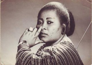
Elizabeth Bessem Ayamo Manga, also known as Bébé Manga, was a Cameroonian makossa singer whose best-known song is "Ami O". She is considered one of the most popular makossa singers of the 1980s.

The Manyu River rises near Wabane

The Tigers of Ambazonia (TTA), also known as Manyu Tigers or Tigers of Manyu, are an Ambazonian separatist militia. According to its official website, the Tigers recognize the authority of the Interim Government of Ambazonia. The militia is part of the Ambazonia Self-Defence Council. The Tigers mainly operate in Manyu and Meme.
Achama is a location in Cameroon located in the department of Momo in the Northwest Region. It is part of the commune of Widikum-Boffe and consists of two villages, Lower Achama and Upper Achama.

Upper Bayang is a district of Cameroon located in the Manyu department and the South West region. The district seat is located at Tinto. Home to the Banyangi people.
Sumbe is a locality of Cameroon located in the South West Region and the department of Manyu. It is administratively attached to the district of Upper Bayang and the township of Tinto.
Nguti is a town and commune in Cameroon. The town covers an area of 1.851 km2. Nguti once had an airstrip, used for the transport of medicine and equipment, but is no longer in use.